TopoQuest Logo
Do you find TopoQuest useful?
Help keep TopoQuest running and adding new maps/features by donating!
Bitcoin:  19c7KJd3qBynnjoSw5npx9KScwjBe4ifkT
Litecoin:  LXs6TkuXGGXo1vDsWCkWVdjQX94eUKd6ui
Home View Maps Find Maps Find Places Resources & Links


Sheridan, Louisiana Topographic Map

USGS Map Title: Sheridan, LA
USGS Map MRC: 30090G1
DRG (GeoTIFF) Download: o30090g1.tif


Neighboring USGS Topographic Map Quads:


  Clifton, LA  
30090H2
 

  Pine, LA  
30090H1
 

  State Line, LA  
30089H8
 

  Franklinton, LA  
30090G2
 

  Sheridan, LA  
30090G1
 

  Bogalusa West, LA  
30089G8
 

  Folsom, LA  
30090F2
 

  Enon, LA  
30090F1
 

  Sun, LA  
30089F8


Map MRC Location:

N31°
W91°
N31°
W90°
H8 H7 H6 H5 H4 H3 H2 H1
G8 G7 G6 G5 G4 G3 G2 G1
F8 F7 F6 F5 F4 F3 F2 F1
E8 E7 E6 E5 E4 E3 E2 E1
D8 D7 D6 D5 D4 D3 D2 D1
C8 C7 C6 C5 C4 C3 C2 C1
B8 B7 B6 B5 B4 B3 B2 B1
A8 A7 A6 A5 A4 A3 A2 A1
N30°
W91°
N30°
W90°

Sheridan, LA USGS 1:24K Topographic Map Preview:
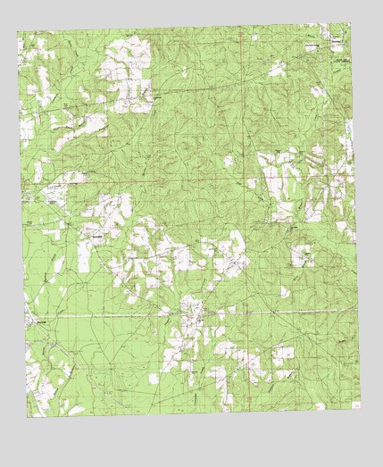
Sheridan, LA USGS Topographic Map
Click on map above to begin viewing in our Map Viewer.

This topographic map contains these locations and features:
Feature Name Type Latitude Longitude GNIS ID View Map
Back SwampSwampN30.7766°W90.1001°543980View Map
Bett CreekStreamN30.8124°W90.0217°553623View Map
Buckeye BranchStreamN30.7796°W90.1156°533503View Map
Burch CreekStreamN30.8638°W90.1029°553835View Map
Choctaw Road LandfillLocaleN30.8443°W90.0442°2600002View Map
Cooper School (historical)SchoolN30.7841°W90.0584°543981View Map
Creel CemeteryCemeteryN30.8332°W90.0784°542062View Map
Ennis BranchStreamN30.8063°W90.0137°554362View Map
Franklinton AirportAirportN30.8204°W90.1148°1632709View Map
Franklinton Country ClubLocaleN30.8231°W90.1126°2601354View Map
Franklinton Elementary SchoolSchoolN30.8539°W90.1240°543977View Map
Franklinton High SchoolSchoolN30.8588°W90.1239°543976View Map
Jenkins CemeteryCemeteryN30.8130°W90.1215°536020View Map
Jenkins CemeteryCemeteryN30.8335°W90.0204°536021View Map
Jesus Name Holiness ChurchChurchN30.8666°W90.0126°542071View Map
Letchworth CemeteryCemeteryN30.8032°W90.0515°536409View Map
Magee CemeteryCemeteryN30.8010°W90.0862°536826View Map
Miller CreekStreamN30.8730°W90.0859°537139View Map
Mount Zion ChurchChurchN30.7802°W90.0604°537436View Map
Oak Grove ChurchChurchN30.8096°W90.0248°537776View Map
Parish Governing Authority District 13 (historical)CivilN30.7582°W90.0267°1929847View Map
Parish Governing Authority District 2CivilN30.7701°W90.0449°1929924View Map
Pine CliffPopulated PlaceN30.7830°W90.1234°559704View Map
Pond BranchStreamN30.8371°W90.1190°538327View Map
Poplarhead ChurchChurchN30.8527°W90.0742°538337View Map
Potato Patch BranchStreamN30.8419°W90.1173°538362View Map
Rester CemeteryCemeteryN30.7974°W90.0001°538569View Map
Sandy Hollow CreekStreamN30.8232°W90.1248°539166View Map
Sanfords Camp (historical)Populated PlaceN30.7594°W90.0570°543982View Map
SheridanPopulated PlaceN30.8685°W90.0031°556022View Map
Simmons CemeteryCemeteryN30.8705°W90.0073°556673View Map
Smith CemeteryCemeteryN30.8566°W90.0106°539432View Map
Smith Pond Number One DamDamN30.8419°W90.0001°556817View Map
Spencer CemeteryCemeteryN30.7635°W90.0637°539548View Map
SpringhillPopulated PlaceN30.8080°W90.1001°556127View Map
Springhill Baptist ChurchChurchN30.8088°W90.1006°559441View Map
Strahan CemeteryCemeteryN30.8296°W90.1009°554867View Map
Thigpen CemeteryCemeteryN30.8332°W90.0284°542099View Map
Thomas CreekStreamN30.8591°W90.0073°539880View Map
Tison CemeteryCemeteryN30.7841°W90.0587°539951View Map
Ward BranchStreamN30.8352°W90.0204°543984View Map
Ward SixCivilN30.7685°W90.0367°545260View Map
Warner CreekStreamN30.7521°W90.1237°559722View Map
Washington ParishCivilN30.8533°W90.0405°559557View Map
Washington Parish Fire District 8BuildingN30.7706°W90.0664°2332714View Map
Williams CemeteryCemeteryN30.8007°W90.0198°540428View Map
Williams Mill (historical)LocaleN30.7996°W90.0181°543983View Map
Witche CreekStreamN30.8613°W90.0081°556464View Map

Note: Coordinates in the location and feature list above are referenced to NAD83 datum.


Copyright (C) 2008-2024 Ryan Niemi / Sunset Dynamics ... All Rights Reserved