TopoQuest Logo
Do you find TopoQuest useful?
Help keep TopoQuest running and adding new maps/features by donating!
Bitcoin:  19c7KJd3qBynnjoSw5npx9KScwjBe4ifkT
Litecoin:  LXs6TkuXGGXo1vDsWCkWVdjQX94eUKd6ui
Home View Maps Find Maps Find Places Resources & Links


Sheridan, Indiana Topographic Map

USGS Map Title: Sheridan, IN
USGS Map MRC: 40086B2
DRG (GeoTIFF) Download: o40086b2.tif


Neighboring USGS Topographic Map Quads:


  Hillisburg, IN  
40086C3
 

  Kempton, IN  
40086C2
 

  Tipton, IN  
40086C1
 

  Kirklin, IN  
40086B3
 

  Sheridan, IN  
40086B2
 

  Arcadia, IN  
40086B1
 

  Rosston, IN  
40086A3
 

  Westfield, IN  
40086A2
 

  Noblesville, IN  
40086A1


Map MRC Location:

N41°
W87°
N41°
W86°
H8 H7 H6 H5 H4 H3 H2 H1
G8 G7 G6 G5 G4 G3 G2 G1
F8 F7 F6 F5 F4 F3 F2 F1
E8 E7 E6 E5 E4 E3 E2 E1
D8 D7 D6 D5 D4 D3 D2 D1
C8 C7 C6 C5 C4 C3 C2 C1
B8 B7 B6 B5 B4 B3 B2 B1
A8 A7 A6 A5 A4 A3 A2 A1
N40°
W87°
N40°
W86°

Sheridan, IN USGS 1:24K Topographic Map Preview:
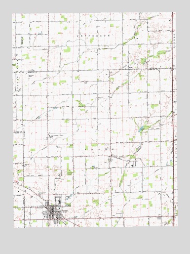
Sheridan, IN USGS Topographic Map
Click on map above to begin viewing in our Map Viewer.

This topographic map contains these locations and features:
Feature Name Type Latitude Longitude GNIS ID View Map
Adams Elementary SchoolSchoolN40.1359°W86.2155°446962View Map
Baker DitchCanalN40.1381°W86.1283°430430View Map
Bakers CornerPopulated PlaceN40.1306°W86.1375°430439View Map
Black Hawk Airport (historical)AirportN40.2139°W86.2375°449346View Map
BoxleyPopulated PlaceN40.1661°W86.1755°431418View Map
Christy DitchCanalN40.2303°W86.2128°432506View Map
Cox DitchCanalN40.2356°W86.1580°433066View Map
Crown View CemeteryCemeteryN40.1442°W86.2298°433214View Map
East UnionPopulated PlaceN40.2173°W86.1283°433938View Map
EkinPopulated PlaceN40.2170°W86.1617°434057View Map
Endicott DitchCanalN40.2198°W86.1611°434195View Map
Fouch DitchCanalN40.1934°W86.1922°434709View Map
Hills ChurchChurchN40.2256°W86.2478°436214View Map
Jay DitchCanalN40.1286°W86.1697°436950View Map
Jones DitchCanalN40.1423°W86.1433°437095View Map
K and S FarmsLocaleN40.1703°W86.1686°2635438View Map
Leander Boyer DitchCanalN40.2125°W86.2186°437699View Map
Legion ParkParkN40.1292°W86.2108°437754View Map
Marion-Adams High SchoolSchoolN40.1359°W86.2155°446963View Map
McKinzie DitchCanalN40.1770°W86.2092°438910View Map
Pearce DitchCanalN40.1920°W86.2258°440960View Map
Phillips CemeteryCemeteryN40.1843°W86.1372°441085View Map
Ridge CemeteryCemeteryN40.2092°W86.1953°441991View Map
Ross DitchCanalN40.1589°W86.1497°442319View Map
SheridanPopulated PlaceN40.1350°W86.2205°443361View Map
Sheridan AirportAirportN40.1775°W86.2211°449348View Map
Sheridan Fire DepartmentBuildingN40.1342°W86.2209°2625869View Map
Sheridan Police DepartmentBuildingN40.1340°W86.2209°2758414View Map
Sheridan Post OfficePost OfficeN40.1354°W86.2215°2775168View Map
Small CemeteryCemeteryN40.2203°W86.1577°443642View Map
Spencer CemeteryCemeteryN40.1617°W86.2417°443938View Map
Spicewood CemeteryCemeteryN40.1330°W86.1667°443946View Map
Symons DitchCanalN40.1509°W86.1914°444527View Map
Teter BranchStreamN40.1664°W86.1592°444653View Map
Teter CemeteryCemeteryN40.1522°W86.1672°444654View Map
Town of SheridanCivilN40.1318°W86.2195°2397655View Map
Township of AdamsCivilN40.1586°W86.1851°453077View Map
Wiles CemeteryCemeteryN40.1444°W86.2001°446027View Map
Windy Knoll AirportAirportN40.1409°W86.1518°449347View Map

Note: Coordinates in the location and feature list above are referenced to NAD83 datum.


Copyright (C) 2008-2024 Ryan Niemi / Sunset Dynamics ... All Rights Reserved