TopoQuest Logo
Do you find TopoQuest useful?
Help keep TopoQuest running and adding new maps/features by donating!
Bitcoin:  19c7KJd3qBynnjoSw5npx9KScwjBe4ifkT
Litecoin:  LXs6TkuXGGXo1vDsWCkWVdjQX94eUKd6ui
Home View Maps Find Maps Find Places Resources & Links


Sherando, Virginia Topographic Map

USGS Map Title: Sherando, VA
USGS Map MRC: 37078H8
DRG (GeoTIFF) Download: o37078h8.tif


Neighboring USGS Topographic Map Quads:


  Stuarts Draft, VA  
38079A1
 

  Waynesboro West, VA  
38078A8
 

  Waynesboro East, VA  
38078A7
 

  Big Levels, VA  
37079H1
 

  Sherando, VA  
37078H8
 

  Greenfield, VA  
37078H7
 

  Massies Mill, VA  
37079G1
 

  Horseshoe Mountain, VA  
37078G8
 

  Lovingston, VA  
37078G7


Map MRC Location:

N38°
W79°
N38°
W78°
H8 H7 H6 H5 H4 H3 H2 H1
G8 G7 G6 G5 G4 G3 G2 G1
F8 F7 F6 F5 F4 F3 F2 F1
E8 E7 E6 E5 E4 E3 E2 E1
D8 D7 D6 D5 D4 D3 D2 D1
C8 C7 C6 C5 C4 C3 C2 C1
B8 B7 B6 B5 B4 B3 B2 B1
A8 A7 A6 A5 A4 A3 A2 A1
N37°
W79°
N37°
W78°

Sherando, VA USGS 1:24K Topographic Map Preview:
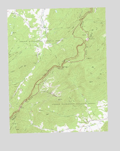
Sherando, VA USGS Topographic Map
Click on map above to begin viewing in our Map Viewer.

This topographic map contains these locations and features:
Feature Name Type Latitude Longitude GNIS ID View Map
Bee MountainSummitN37.8787°W78.9917°1481586View Map
Beech GrovePopulated PlaceN37.8757°W78.9389°1481590View Map
Big LevelsFlatN37.9404°W78.8934°1481746View Map
Black Rock MountainSummitN37.9082°W78.9370°1481829View Map
Blue Ridge Parkway Visitors CenterBuildingN37.9765°W78.9031°1488645View Map
Bryant MountainSummitN37.8935°W78.9528°1482088View Map
Crawford KnobSummitN37.9251°W78.8972°1482818View Map
Devils KnobSummitN37.9162°W78.9547°1482990View Map
Diamond Hill CemeteryCemeteryN37.9204°W78.9120°1482997View Map
Dobie MountainSummitN37.9771°W78.8934°1483043View Map
Dripping RockSummitN37.9399°W78.9359°1499357View Map
Elk Hill ChurchChurchN37.8804°W78.8981°1483275View Map
Falling Rocks LakeReservoirN37.9635°W78.9497°1489174View Map
Grassy RidgeRidgeN37.9076°W78.9195°1483757View Map
Greenstone OverlookLocaleN37.9471°W78.9272°1483825View Map
Happy Hollow LakeReservoirN37.9970°W78.9374°1489190View Map
Hickory SpringSpringN37.9235°W78.9659°1484072View Map
Humpback GapGapN37.9687°W78.8961°1484275View Map
Humpback MountainSummitN37.9487°W78.8986°1499585View Map
Humpback Rocks Visitors CenterLocaleN37.9729°W78.8989°1484276View Map
Lake WildaReservoirN37.9920°W78.9905°1489188View Map
Laurel Springs BranchStreamN37.9640°W78.9534°1484729View Map
Laurel Springs GapGapN37.9401°W78.9314°1484732View Map
Little Country ChurchChurchN37.9960°W78.9909°1484884View Map
Little CreekStreamN37.8829°W78.9689°1484892View Map
Little LevelsFlatN37.9329°W78.8845°1484923View Map
Little Stony CreekStreamN37.9040°W78.8995°1484984View Map
Maple Flat PondsReservoirN37.9769°W78.9944°1485168View Map
Maupin Field ShelterLocaleN37.8854°W78.9920°1485229View Map
Meadow MountainSummitN37.8904°W78.9939°1499724View Map
Mills CreekStreamN37.9812°W78.9539°1485475View Map
Mount Torry FurnacePopulated PlaceN37.9454°W78.9639°1499778View Map
Mountain View ChurchChurchN37.9218°W78.9881°1485705View Map
Nellysford Census Designated PlaceCensusN37.9129°W78.8827°2584888View Map
Nellysford Post OfficePost OfficeN37.8886°W78.8766°2766258View Map
North Fork Back CreekStreamN37.9287°W78.9800°1485886View Map
Orebank CreekStreamN37.9671°W78.9556°1485987View Map
Pine RidgeRidgeN37.9779°W78.9172°1486223View Map
Piney MountainSummitN37.8968°W78.9628°1486253View Map
PJs MoundSummitN37.8904°W78.9664°1488668View Map
Pond HollowValleyN37.9000°W78.9724°1486324View Map
Potatopatch MountainSummitN37.9162°W78.9547°1499902View Map
Ravens Roost OverlookLocaleN37.9335°W78.9522°1486522View Map
Reids CreekStreamN37.8799°W78.9006°1486562View Map
Reids GapGapN37.9015°W78.9853°1486563View Map
Rock Point OverlookLocaleN37.9374°W78.9484°1486705View Map
Rockfish AirparkAirportN37.8791°W78.8930°1498857View Map
SherandoPopulated PlaceN37.9812°W78.9539°1500091View Map
Sherando CampLocaleN37.9543°W78.9620°1487186View Map
Sherando Census Designated PlaceCensusN37.9889°W78.9443°2390293View Map
Sherando ChurchChurchN37.9535°W78.9628°1487187View Map
South Fork Back CreekStreamN37.9287°W78.9800°1487391View Map
South River DistrictCivilN37.9825°W78.9752°1927508View Map
South River Number 11 DamDamN37.9935°W78.9914°1489187View Map
South River Number 24 DamDamN37.9985°W78.9381°1489189View Map
South River Number 25 DamDamN37.9635°W78.9497°1489173View Map
Spruce CreekStreamN37.8826°W78.8850°1487482View Map
Stony CreekStreamN37.8838°W78.8784°1487614View Map
The RocksSummitN37.9610°W78.9003°1500216View Map
Three Ridges OverlookLocaleN37.9071°W78.9789°1487900View Map
Toms BranchStreamN37.9643°W78.9486°1487947View Map
Torry MountainSummitN37.9429°W78.9800°1487955View Map
Turkey Pen RidgeRidgeN37.9501°W78.9997°1488028View Map
Turkey Pen Ridge TrailTrailN37.9521°W78.9906°1488029View Map
WintergreenPopulated PlaceN37.8849°W78.8995°1488428View Map
Wintergreen CemeteryCemeteryN37.8999°W78.9008°1488429View Map
Wintergreen Census Designated PlaceCensusN37.9161°W78.9382°2584937View Map
Wintergreen Fire and Rescue Station 1BuildingN37.9128°W78.9459°2721071View Map
Wintergreen Fire and Rescue Station 2BuildingN37.8947°W78.8763°2086121View Map

Note: Coordinates in the location and feature list above are referenced to NAD83 datum.


Copyright (C) 2008-2024 Ryan Niemi / Sunset Dynamics ... All Rights Reserved