TopoQuest Logo
Do you find TopoQuest useful?
Help keep TopoQuest running and adding new maps/features by donating!
Bitcoin:  19c7KJd3qBynnjoSw5npx9KScwjBe4ifkT
Litecoin:  LXs6TkuXGGXo1vDsWCkWVdjQX94eUKd6ui
Home View Maps Find Maps Find Places Resources & Links


Sheepy Lake, California Topographic Map

USGS Map Title: Sheepy Lake, CA
USGS Map MRC: 41121H7
DRG (GeoTIFF) Download: o41121h7.tif


Neighboring USGS Topographic Map Quads:


  Hamaker Mountain, OR  
42121A8
 

  Worden, OR  
42121A7
 

  Lost River, OR  
42121A6
 

  Dorris, CA  
41121H8
 

  Sheepy Lake, CA  
41121H7
 

  Lower Klamath Lake, CA  
41121H6
 

  Sheep Mountain, CA  
41121G8
 

  Red Rock Lakes, CA  
41121G7
 

  Mount Dome, CA  
41121G6


Map MRC Location:

N42°
W122°
N42°
W121°
H8 H7 H6 H5 H4 H3 H2 H1
G8 G7 G6 G5 G4 G3 G2 G1
F8 F7 F6 F5 F4 F3 F2 F1
E8 E7 E6 E5 E4 E3 E2 E1
D8 D7 D6 D5 D4 D3 D2 D1
C8 C7 C6 C5 C4 C3 C2 C1
B8 B7 B6 B5 B4 B3 B2 B1
A8 A7 A6 A5 A4 A3 A2 A1
N41°
W122°
N41°
W121°

Sheepy Lake, CA USGS 1:24K Topographic Map Preview:
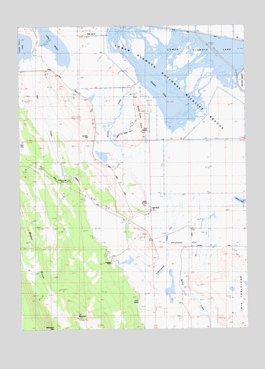
Sheepy Lake, CA USGS Topographic Map
Click on map above to begin viewing in our Map Viewer.

This topographic map contains these locations and features:
Feature Name Type Latitude Longitude GNIS ID View Map
Beal LakeLakeN41.9524°W121.8742°1657360View Map
Big TablelandFlatN41.8821°W121.7503°257035View Map
Clark SpringSpringN41.8857°W121.8111°1657372View Map
Cottonwood CreekStreamN41.9307°W121.7956°221638View Map
D Ranch SpringSpringN41.9365°W121.8497°1657375View Map
Ford SpringSpringN41.9568°W121.8050°1657384View Map
Horsefly GapGapN41.9538°W121.8372°1657392View Map
Hot CreekStreamN41.9860°W121.8700°225668View Map
J F MountainSummitN41.8793°W121.8450°252314View Map
Jacks SpringSpringN41.9265°W121.8058°1657396View Map
Langer RanchLocaleN41.9243°W121.8028°226856View Map
Mahogany MountainSummitN41.8751°W121.8586°227951View Map
Oklahoma FlatFlatN41.9093°W121.7831°229955View Map
Oklahoma SchoolSchoolN41.9165°W121.7764°229956View Map
Otey IslandIslandN41.9951°W121.8383°230145View Map
Porterfield RanchLocaleN41.9024°W121.8256°230957View Map
Sheepy CreekStreamN41.9771°W121.8089°232919View Map
Sheepy Creek IslandIslandN41.9604°W121.8083°232920View Map
Sheepy LakeLakeN41.9684°W121.7933°232921View Map
Willow CreekStreamN41.9288°W121.7572°237899View Map

Note: Coordinates in the location and feature list above are referenced to NAD83 datum.


Copyright (C) 2008-2024 Ryan Niemi / Sunset Dynamics ... All Rights Reserved