TopoQuest Logo
Do you find TopoQuest useful?
Help keep TopoQuest running and adding new maps/features by donating!
Bitcoin:  19c7KJd3qBynnjoSw5npx9KScwjBe4ifkT
Litecoin:  LXs6TkuXGGXo1vDsWCkWVdjQX94eUKd6ui
Home View Maps Find Maps Find Places Resources & Links


Shankleville, Texas Topographic Map

USGS Map Title: Shankleville, TX
USGS Map MRC: 30093H6
DRG (GeoTIFF) Download: o30093h6.tif


Neighboring USGS Topographic Map Quads:


  Weeks Settlement, TX  
31093A7
 

  Wiergate, TX  
31093A6
 

  Wiergate SE, TX  
31093A5
 

  Jamestown, TX  
30093H7
 

  Shankleville, TX  
30093H6
 

  Evans, LA  
30093H5
 

  Newton West, TX  
30093G7
 

  Newton East, TX  
30093G6
 

  Merryville North, LA  
30093G5


Map MRC Location:

N31°
W94°
N31°
W93°
H8 H7 H6 H5 H4 H3 H2 H1
G8 G7 G6 G5 G4 G3 G2 G1
F8 F7 F6 F5 F4 F3 F2 F1
E8 E7 E6 E5 E4 E3 E2 E1
D8 D7 D6 D5 D4 D3 D2 D1
C8 C7 C6 C5 C4 C3 C2 C1
B8 B7 B6 B5 B4 B3 B2 B1
A8 A7 A6 A5 A4 A3 A2 A1
N30°
W94°
N30°
W93°

Shankleville, TX USGS 1:24K Topographic Map Preview:
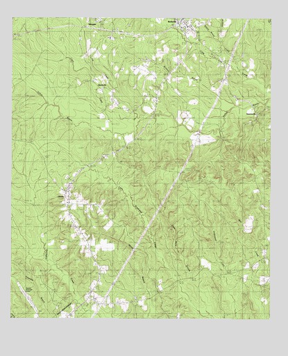
Shankleville, TX USGS Topographic Map
Click on map above to begin viewing in our Map Viewer.

This topographic map contains these locations and features:
Feature Name Type Latitude Longitude GNIS ID View Map
Balance BranchStreamN30.9916°W93.6516°1350780View Map
BurkevillePopulated PlaceN30.9999°W93.6680°1372835View Map
Burkeville Lookout TowerTowerN30.9374°W93.6671°1384536View Map
Burkeville Post OfficePost OfficeN30.9992°W93.6694°2732120View Map
Cat CreekStreamN30.9591°W93.6868°1353956View Map
Clear CreekStreamN30.9596°W93.6902°1354621View Map
Dave Mack BranchStreamN30.8760°W93.6527°1355665View Map
Griggs CemeteryCemeteryN30.9041°W93.6302°1358445View Map
Hackberry BranchStreamN30.8996°W93.7349°1358566View Map
Harrol HollowValleyN30.9996°W93.6605°1350800View Map
LibertyPopulated PlaceN30.9233°W93.7227°1361141View Map
McGraw CreekStreamN30.9791°W93.6402°1362468View Map
Mount Hope ChurchChurchN30.9744°W93.7116°1363256View Map
Newton County Emergency Services District 4BuildingN30.9988°W93.6688°2655502View Map
Newton Municipal AirportAirportN30.8844°W93.7418°1387247View Map
QuicksandPopulated PlaceN30.8827°W93.7138°2034883View Map
Richland BranchStreamN30.9627°W93.6441°1366427View Map
Saint Johns CemeteryCemeteryN30.9302°W93.6271°1367178View Map
Saint Luke ChurchChurchN30.9727°W93.6802°1367226View Map
ShanklevillePopulated PlaceN30.9702°W93.7068°1380524View Map
Simmons CemeteryCemeteryN30.9505°W93.6496°1368292View Map
SimmonsvillePopulated PlaceN30.9605°W93.6324°1380542View Map
StringtownPopulated PlaceN30.9080°W93.6252°1380617View Map
WiergatePopulated PlaceN30.9996°W93.7077°1376780View Map

Note: Coordinates in the location and feature list above are referenced to NAD83 datum.


Copyright (C) 2008-2024 Ryan Niemi / Sunset Dynamics ... All Rights Reserved