TopoQuest Logo
Do you find TopoQuest useful?
Help keep TopoQuest running and adding new maps/features by donating!
Bitcoin:  19c7KJd3qBynnjoSw5npx9KScwjBe4ifkT
Litecoin:  LXs6TkuXGGXo1vDsWCkWVdjQX94eUKd6ui
Home View Maps Find Maps Find Places Resources & Links


Shady Grove, Tennessee Topographic Map

USGS Map Title: Shady Grove, TN
USGS Map MRC: 35083H4
DRG (GeoTIFF) Download: o35083h4.tif


Neighboring USGS Topographic Map Quads:


  New Market, TN  
36083A5
 

  Jefferson City, TN  
36083A4
 

  White Pine, TN  
36083A3
 

  Douglas Dam, TN  
35083H5
 

  Shady Grove, TN  
35083H4
 

  Chestnut Hill, TN  
35083H3
 

  Pigeon Forge, TN  
35083G5
 

  Richardson Cove, TN  
35083G4
 

  Jones Cove, TN  
35083G3


Map MRC Location:

N36°
W84°
N36°
W83°
H8 H7 H6 H5 H4 H3 H2 H1
G8 G7 G6 G5 G4 G3 G2 G1
F8 F7 F6 F5 F4 F3 F2 F1
E8 E7 E6 E5 E4 E3 E2 E1
D8 D7 D6 D5 D4 D3 D2 D1
C8 C7 C6 C5 C4 C3 C2 C1
B8 B7 B6 B5 B4 B3 B2 B1
A8 A7 A6 A5 A4 A3 A2 A1
N35°
W84°
N35°
W83°

Shady Grove, TN USGS 1:24K Topographic Map Preview:
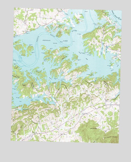
Shady Grove, TN USGS Topographic Map
Click on map above to begin viewing in our Map Viewer.

This topographic map contains these locations and features:
Feature Name Type Latitude Longitude GNIS ID View Map
Ailey ChapelChurchN35.9390°W83.4102°1304777View Map
Ailey School (historical)SchoolN35.9379°W83.4124°1318587View Map
Aileys Chapel CemeteryCemeteryN35.9387°W83.4102°1318588View Map
Allen CemeteryCemeteryN35.9009°W83.4340°1275586View Map
Allensville (historical)Populated PlaceN35.9126°W83.4871°1312976View Map
Alley Ford (historical)CrossingN35.9640°W83.4716°1644961View Map
Alley Ford ShoalsBarN35.9634°W83.4716°1644962View Map
Anderson BranchStreamN35.9431°W83.3785°1275691View Map
Big BranchStreamN35.9629°W83.4246°1311201View Map
Bird Island (historical)IslandN35.9495°W83.4918°1311202View Map
Boat Gunnel HollowValleyN35.9045°W83.4430°1305328View Map
Brown CemeteryCemeteryN35.8998°W83.4382°1278545View Map
Cawoods ShoalBarN35.9979°W83.4202°1644965View Map
Chambers BranchStreamN35.9545°W83.3966°1280207View Map
Commissioner District 2CivilN35.9995°W83.4961°2463938View Map
Commissioner District 3CivilN35.8969°W83.4261°2464195View Map
Dentons ShoalsBarN35.9737°W83.4529°1644967View Map
Derrick CemeteryCemeteryN35.9123°W83.4496°1282363View Map
Douglas LakeReservoirN35.9926°W83.3754°1282739View Map
Eden CemeteryCemeteryN35.9234°W83.4710°1318625View Map
Eden ChurchChurchN35.9231°W83.4713°1306414View Map
Ernest Fox Island (historical)IslandN35.9468°W83.4907°1311215View Map
Fains ShoalsBarN35.9806°W83.4085°1644971View Map
Fair GardenPopulated PlaceN35.9023°W83.4129°1283969View Map
Fair Garden CemeteryCemeteryN35.8945°W83.4199°1283970View Map
Fairgarden Census Designated PlaceCensusN35.8915°W83.4108°2584578View Map
Fairgarden School (historical)SchoolN35.8873°W83.4229°1323359View Map
Finchum CemeteryCemeteryN35.9268°W83.4718°1284263View Map
Finchum HollowValleyN35.9295°W83.4577°1284264View Map
Finchum Store (historical)LocaleN35.9320°W83.4696°1318631View Map
Flat Creek CampgroundLocaleN35.9273°W83.4924°1323368View Map
Fox (historical)Populated PlaceN35.9093°W83.3957°1312986View Map
Fox CemeteryCemeteryN35.9101°W83.3754°1284767View Map
Fox ChurchChurchN35.9079°W83.3893°1306455View Map
Fox Island (historical)IslandN35.9601°W83.4724°1311217View Map
Fox School (historical)SchoolN35.9068°W83.3896°1323370View Map
Foxes Store (historical)LocaleN35.9576°W83.4341°1318633View Map
Frye BranchStreamN35.9826°W83.4702°1285002View Map
Gator Point CampgroundLocaleN35.9415°W83.4927°1318639View Map
Goose CreekStreamN35.9979°W83.4441°1285672View Map
Halbert CemeteryCemeteryN35.9379°W83.4268°1286508View Map
Happy HollowValleyN35.9046°W83.4874°1286765View Map
Harrison Islands (historical)IslandN35.9523°W83.4913°1311222View Map
Harrison ShoalsBarN35.9518°W83.4896°1644972View Map
Henderson IslandIslandN35.9926°W83.4254°1311224View Map
Henderson Island Wildlife RefugeParkN35.9918°W83.4249°1318651View Map
Hettie CreekStreamN35.9076°W83.4443°1287524View Map
Hills Union CemeteryCemeteryN35.9570°W83.3785°1318654View Map
Hills Union ChurchChurchN35.9573°W83.3777°1287842View Map
Holbert Branch (historical)StreamN35.9690°W83.4713°1311225View Map
Hunter Island (historical)IslandN35.9990°W83.4185°1311226View Map
Inspiration Point DockLocaleN35.9606°W83.4138°1318659View Map
Island Ford Mill (historical)LocaleN35.9543°W83.4902°1318660View Map
Jones CemeteryCemeteryN35.9201°W83.4593°1289739View Map
Jones ChapelChurchN35.9193°W83.4554°1306636View Map
Jones Chapel CemeteryCemeteryN35.9195°W83.4560°1645429View Map
Jones Chapel School (historical)SchoolN35.9195°W83.4566°1323382View Map
Lakefront DockLocaleN35.9740°W83.4971°1290501View Map
Lee Academy (historical)SchoolN35.9656°W83.4513°1318678View Map
Leeper Branch (historical)StreamN35.9643°W83.4749°1311236View Map
Little MountainSummitN35.8876°W83.4088°1291580View Map
Long HollowValleyN35.8804°W83.4936°1291953View Map
Manning Branch (historical)StreamN35.9631°W83.4271°1311239View Map
McCracken BranchStreamN35.9506°W83.4643°1293210View Map
McGuire CreekStreamN35.9415°W83.4596°1293332View Map
McMann Island (historical)IslandN35.9923°W83.4127°1311243View Map
Miller CreekStreamN35.9331°W83.4477°1311244View Map
Mountain View DockLocaleN35.9573°W83.4099°1294955View Map
Muddy CreekStreamN35.9687°W83.4285°1295043View Map
Muddy HollowValleyN35.9320°W83.4437°1295050View Map
Mullins ChapelChurchN35.9876°W83.3868°1295088View Map
New Center Elementary SchoolSchoolN35.8818°W83.4407°1648444View Map
Nichols ReefBarN35.9784°W83.4199°1644974View Map
Old EgyptSummitN35.9620°W83.4441°1296300View Map
Parrot ChurchChurchN35.9337°W83.4393°1296883View Map
Parrott School (historical)SchoolN35.9337°W83.4402°1318711View Map
Parrotts Chapel CemeteryCemeteryN35.9337°W83.4396°1318710View Map
Patterson BranchStreamN35.8884°W83.4404°1296926View Map
Patterson BranchStreamN35.9568°W83.4043°1296928View Map
Patterson BranchStreamN35.9781°W83.4843°1296932View Map
Patterson CemeteryCemeteryN35.9981°W83.4807°1296943View Map
Patterson HollowValleyN35.9484°W83.4452°1296965View Map
Perry BranchStreamN35.9420°W83.4810°1297199View Map
Pleasant Hill (historical)Populated PlaceN35.9612°W83.4224°1311248View Map
Red Oak KnobsSummitN35.9276°W83.4818°1299076View Map
Riverview School (historical)SchoolN35.9431°W83.4793°1318721View Map
Roaring SpringSpringN35.9166°W83.3831°1299573View Map
Rollins BranchStreamN35.9362°W83.4035°1300034View Map
Sandy RidgePopulated PlaceN35.9562°W83.3763°1315873View Map
Sandy Ridge BranchStreamN35.9584°W83.3910°1300767View Map
Sandy Ridge Mill (historical)LocaleN35.9648°W83.3916°1318725View Map
Schroder (historical)Populated PlaceN35.9290°W83.4204°1652110View Map
Sevier County Volunteer Fire Department Station 2BuildingN35.8799°W83.4440°2654904View Map
Shadden CreekStreamN35.9851°W83.4274°1301146View Map
Shady GrovePopulated PlaceN35.9784°W83.4841°1315905View Map
Shady Grove CemeteryCemeteryN35.9798°W83.4813°1647477View Map
Shady Grove DockLocaleN35.9779°W83.4838°1318728View Map
Silva BranchStreamN35.9112°W83.4868°1313010View Map
Sims CemeteryCemeteryN35.9251°W83.4146°1270352View Map
Sims Chapel CemeteryCemeteryN35.9281°W83.4232°1645480View Map
Sims ChurchChurchN35.9281°W83.4241°1303635View Map
Sims School (historical)SchoolN35.9281°W83.4196°1323434View Map
Slatey Creek (historical)StreamN35.9909°W83.3816°1311254View Map
Smoky View CampgroundLocaleN35.9876°W83.4379°1318733View Map
Stafford CemeteryCemeteryN35.8768°W83.4799°1645483View Map
Sugar Camp HollowValleyN35.8918°W83.4683°1271649View Map
Swann CemeteryCemeteryN35.9873°W83.3863°1271950View Map
Swann Island (historical)IslandN35.9884°W83.3754°1311259View Map
Swanns Island ShoalsBarN35.9862°W83.3763°1644976View Map
Tater KnobSummitN35.9904°W83.4268°1272164View Map
Terry Point Boat DockLocaleN35.9904°W83.4366°1318743View Map
Terry Point CampgroundLocaleN35.9906°W83.4352°1318742View Map
The SinkBasinN35.8793°W83.3924°1272441View Map
Walnut GrovePopulated PlaceN35.8829°W83.4696°1314470View Map
Walnut Grove Baptist ChurchChurchN35.8829°W83.4696°1645495View Map
Walnut Grove BranchStreamN35.8779°W83.4760°1273716View Map
Walnut Grove CemeteryCemeteryN35.8765°W83.4796°1273718View Map
Walnut Grove School (historical)SchoolN35.8834°W83.4707°1323443View Map
Weaver DockLocaleN35.9595°W83.4121°1273996View Map
Wells BranchStreamN35.9981°W83.4441°1304442View Map

Note: Coordinates in the location and feature list above are referenced to NAD83 datum.


Copyright (C) 2008-2024 Ryan Niemi / Sunset Dynamics ... All Rights Reserved