TopoQuest Logo
Do you find TopoQuest useful?
Help keep TopoQuest running and adding new maps/features by donating!
Bitcoin:  19c7KJd3qBynnjoSw5npx9KScwjBe4ifkT
Litecoin:  LXs6TkuXGGXo1vDsWCkWVdjQX94eUKd6ui
Home View Maps Find Maps Find Places Resources & Links


Seneca, Oregon Topographic Map

USGS Map Title: Seneca, OR
USGS Map MRC: 44118B8
DRG (GeoTIFF) Download: o44118b8.tif


Neighboring USGS Topographic Map Quads:


  Fall Mountain, OR  
44119C1
 

  Canyon Mountain, OR  
44118C8
 

  Pine Creek Mountain, OR  
44118C7
 

  Scotty Creek, OR  
44119B1
 

  Seneca, OR  
44118B8
 

  Big Canyon, OR  
44118B7
 

  Rail Creek Butte, OR  
44119A1
 

  Silvies, OR  
44118A8
 

  Jump-off Joe Mountain, OR  
44118A7


Map MRC Location:

N45°
W119°
N45°
W118°
H8 H7 H6 H5 H4 H3 H2 H1
G8 G7 G6 G5 G4 G3 G2 G1
F8 F7 F6 F5 F4 F3 F2 F1
E8 E7 E6 E5 E4 E3 E2 E1
D8 D7 D6 D5 D4 D3 D2 D1
C8 C7 C6 C5 C4 C3 C2 C1
B8 B7 B6 B5 B4 B3 B2 B1
A8 A7 A6 A5 A4 A3 A2 A1
N44°
W119°
N44°
W118°

Seneca, OR USGS 1:24K Topographic Map Preview:
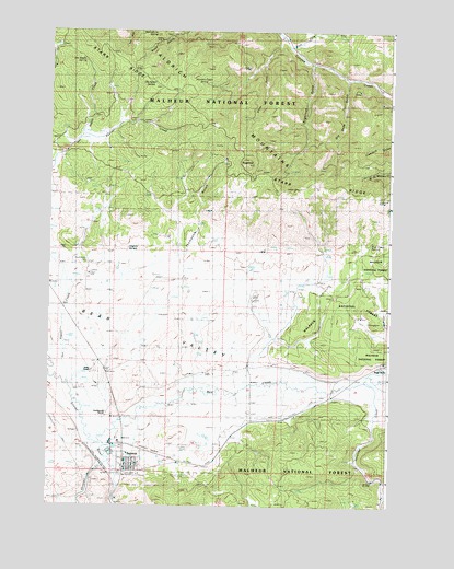
Seneca, OR USGS Topographic Map
Click on map above to begin viewing in our Map Viewer.

This topographic map contains these locations and features:
Feature Name Type Latitude Longitude GNIS ID View Map
Antelope CreekStreamN44.1577°W118.8830°1137238View Map
Bear CreekStreamN44.1429°W118.9799°1137671View Map
Big Glade SpringSpringN44.1851°W118.9539°1154234View Map
Biggs RanchLocaleN44.1624°W118.8780°1156982View Map
Bull Run ReservoirReservoirN44.1700°W118.9468°1154231View Map
Bull Run SpringSpringN44.1749°W118.9442°1154232View Map
City of SenecaCivilN44.1352°W118.9763°2411867View Map
Dry Soda GulchValleyN44.2410°W118.9036°1141359View Map
Dry Soda LookoutLocaleN44.2082°W118.9108°1152974View Map
East Fork Canyon CreekStreamN44.2460°W118.9116°1141541View Map
Frys Camp SpringSpringN44.1937°W118.8827°1142524View Map
H S Johnson DamSpringN44.2032°W118.9543°1153909View Map
H S Johnson ReservoirReservoirN44.2032°W118.9544°1153908View Map
Hagney SpringSpringN44.1926°W118.9714°1154235View Map
Herberger SpringSpringN44.2366°W118.9643°1143505View Map
Honeymoon CreekStreamN44.1432°W118.9858°1158869View Map
Hunters Cabin SpringSpringN44.2359°W118.9447°1143943View Map
Jimmy CreekStreamN44.1574°W118.9927°1158870View Map
Moonshine SpringSpringN44.2491°W118.9622°1146431View Map
Oliver RanchLocaleN44.1607°W118.9841°1124986View Map
Pearson CreekStreamN44.2221°W118.9888°1147531View Map
Rex ReservoirReservoirN44.1679°W118.9386°1154230View Map
SenecaPopulated PlaceN44.1346°W118.9716°1149228View Map
Seneca City HallBuildingN44.1343°W118.9706°2700287View Map
Seneca Elementary SchoolSchoolN44.1364°W118.9719°2417175View Map
Seneca Emergency AirstripAirportN44.1353°W118.9796°2646046View Map
Seneca Post OfficePost OfficeN44.1347°W118.9719°1165929View Map
Seneca Public Works Department OfficeBuildingN44.1343°W118.9706°2700288View Map
Seneca SubstationLocaleN44.1696°W118.9869°1149229View Map
Seneca Volunteer Fire DepartmentBuildingN44.1343°W118.9704°2576949View Map
Seneca Wastewater Treatment LagoonLocaleN44.1387°W118.9772°2697179View Map
Seneca WellWellN44.1349°W118.9788°1154229View Map
Shields SpringSpringN44.1800°W118.9551°1154233View Map
Shirttail CreekStreamN44.1360°W118.9811°1149406View Map
Sloan GulchValleyN44.2482°W118.9141°1149727View Map
South Fork Antelope CreekStreamN44.1304°W118.8763°1149922View Map
Southworth CemeteryCemeteryN44.1885°W118.9872°1133915View Map
Southworth DitchCanalN44.1554°W118.9552°1152972View Map
Southworth RanchLocaleN44.1496°W118.9788°1156981View Map
SugarloafSummitN44.2149°W118.9283°1150548View Map
Sugarloaf GulchValleyN44.2407°W118.9038°1150551View Map
Sugarloaf SpringSpringN44.2177°W118.9313°1150562View Map
Thompson GulchValleyN44.1907°W118.9511°1151106View Map
Van Aspen SpringSpringN44.2419°W118.9881°1156980View Map
Yeoville Post Office (historical)Post OfficeN44.2068°W118.9991°1164799View Map

Note: Coordinates in the location and feature list above are referenced to NAD83 datum.


Copyright (C) 2008-2024 Ryan Niemi / Sunset Dynamics ... All Rights Reserved