TopoQuest Logo
Do you find TopoQuest useful?
Help keep TopoQuest running and adding new maps/features by donating!
Bitcoin:  19c7KJd3qBynnjoSw5npx9KScwjBe4ifkT
Litecoin:  LXs6TkuXGGXo1vDsWCkWVdjQX94eUKd6ui
Home View Maps Find Maps Find Places Resources & Links


Selah, Washington Topographic Map

USGS Map Title: Selah, WA
USGS Map MRC: 46120F5
DRG (GeoTIFF) Download: o46120f5.tif


Neighboring USGS Topographic Map Quads:


  Wenas Lake, WA  
46120G6
 

  The Cottonwoods, WA  
46120G5
 

  Wymer, WA  
46120G4
 

  Naches, WA  
46120F6
 

  Selah, WA  
46120F5
 

  Pomona, WA  
46120F4
 

  Wiley City, WA  
46120E6
 

  Yakima West, WA  
46120E5
 

  Yakima East, WA  
46120E4


Map MRC Location:

N47°
W121°
N47°
W120°
H8 H7 H6 H5 H4 H3 H2 H1
G8 G7 G6 G5 G4 G3 G2 G1
F8 F7 F6 F5 F4 F3 F2 F1
E8 E7 E6 E5 E4 E3 E2 E1
D8 D7 D6 D5 D4 D3 D2 D1
C8 C7 C6 C5 C4 C3 C2 C1
B8 B7 B6 B5 B4 B3 B2 B1
A8 A7 A6 A5 A4 A3 A2 A1
N46°
W121°
N46°
W120°

Selah, WA USGS 1:24K Topographic Map Preview:
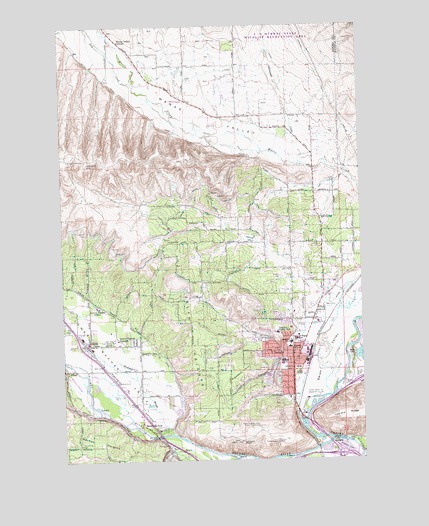
Selah, WA USGS Topographic Map
Click on map above to begin viewing in our Map Viewer.

This topographic map contains these locations and features:
Feature Name Type Latitude Longitude GNIS ID View Map
Berglund LakeReservoirN46.6277°W120.5170°1534568View Map
BracePopulated PlaceN46.6276°W120.5773°1510835View Map
Buckskin SloughStreamN46.6321°W120.5795°1503624View Map
Carlon ParkParkN46.6629°W120.5262°1510587View Map
City of SelahCivilN46.6482°W120.5389°2411862View Map
Cottonwood CreekStreamN46.7098°W120.5248°1504165View Map
Cowiche CanyonValleyN46.6279°W120.5826°1504213View Map
Cowiche CreekStreamN46.6279°W120.5687°1504214View Map
Crusher CanyonValleyN46.6535°W120.5356°1504294View Map
Dry CreekStreamN46.7326°W120.5945°1504557View Map
Elks Golf and Country ClubLocaleN46.6421°W120.5245°1533112View Map
GleedPopulated PlaceN46.6582°W120.6134°1512241View Map
Gleed Census Designated PlaceCensusN46.6593°W120.6025°2408297View Map
Gleed DitchCanalN46.6662°W120.6023°1505147View Map
Indian Painted Rocks State ParkParkN46.6296°W120.5840°1511596View Map
Iowa FlatFlatN46.7368°W120.5584°1505745View Map
John Campbell Elementary SchoolSchoolN46.6585°W120.5313°1530822View Map
KUTI-AM (Selah)TowerN46.6401°W120.5978°1534507View Map
KYXE-AM (Selah)TowerN46.6673°W120.5148°1534506View Map
Legion ParkParkN46.6562°W120.5356°1510590View Map
Lookout PointCliffN46.6301°W120.5523°1506307View Map
Lower Naches Community ParkParkN46.6587°W120.6026°1506357View Map
Lower Naches GrangeLocaleN46.6596°W120.6034°1506358View Map
Lower Naches ValleyValleyN46.6362°W120.5831°1506360View Map
Naches RiverStreamN46.6307°W120.5145°1523553View Map
Naches Valley Primary SchoolSchoolN46.7448°W120.6020°1515303View Map
Naches Valley Primary SchoolSchoolN46.6693°W120.6122°1506359View Map
Number 1 LateralCanalN46.6804°W120.5781°1506997View Map
Number 2 LateralCanalN46.6762°W120.5553°1506998View Map
Palm ParkParkN46.6482°W120.5398°1510589View Map
Pleasant HillSummitN46.6504°W120.5512°1512570View Map
Pulse Alternative SchoolSchoolN46.6621°W120.5278°1515297View Map
Ramblers ParkLocaleN46.6348°W120.5928°1507711View Map
Robert S Lince Intermediate SchoolSchoolN46.6532°W120.5342°1515299View Map
Rotary LakeLakeN46.6283°W120.5093°1534212View Map
SelahPopulated PlaceN46.6540°W120.5301°1512655View Map
Selah Fire DepartmentBuildingN46.6557°W120.5325°2619453View Map
Selah HeightsLocaleN46.6715°W120.5687°1534083View Map
Selah HeightsSummitN46.6612°W120.5723°1512656View Map
Selah High SchoolSchoolN46.6648°W120.5295°1515298View Map
Selah Middle SchoolSchoolN46.6591°W120.5293°1515270View Map
Selah Police DepartmentBuildingN46.6437°W120.5301°2721916View Map
Selah Post OfficePost OfficeN46.6536°W120.5293°2769127View Map
Selah ValleyValleyN46.6371°W120.5265°1508212View Map
Spring CreekStreamN46.6340°W120.5826°1508626View Map
Sunset SchoolSchoolN46.6571°W120.5312°1508844View Map
Twin BridgesLocaleN46.6298°W120.5151°1509140View Map
Viking Village Shopping CenterLocaleN46.6518°W120.5301°1514619View Map
Wenas Mammoth MountainSummitN46.7114°W120.6147°2760757View Map
Wenas ValleyValleyN46.7107°W120.5281°1527896View Map
Wenas Valley GrangeLocaleN46.7454°W120.6006°1509373View Map
Wixon ParkParkN46.6510°W120.5337°1510588View Map
Yakima County Fire District 2 Selah Fire Department Station 4BuildingN46.7123°W120.5202°2643444View Map
Yakima County Fire District 6 Station 1BuildingN46.6573°W120.6146°2643427View Map
Yakima County Fire District 6 Station 2BuildingN46.6434°W120.5942°2643426View Map
Yakima Valley SchoolSchoolN46.6612°W120.5365°1509648View Map

Note: Coordinates in the location and feature list above are referenced to NAD83 datum.


Copyright (C) 2008-2024 Ryan Niemi / Sunset Dynamics ... All Rights Reserved