TopoQuest Logo
Do you find TopoQuest useful?
Help keep TopoQuest running and adding new maps/features by donating!
Bitcoin:  19c7KJd3qBynnjoSw5npx9KScwjBe4ifkT
Litecoin:  LXs6TkuXGGXo1vDsWCkWVdjQX94eUKd6ui
Home View Maps Find Maps Find Places Resources & Links


Seamans Creek, Idaho Topographic Map

USGS Map Title: Seamans Creek, ID
USGS Map MRC: 43114D2
DRG (GeoTIFF) Download: o43114d2.tif


Neighboring USGS Topographic Map Quads:


  Hailey, ID  
43114E3
 

  Baugh Creek SW, ID  
43114E2
 

  Baugh Creek, ID  
43114E1
 

  Bellevue, ID  
43114D3
 

  Seamans Creek, ID  
43114D2
 

  Little Wood River Reservoir, ID  
43114D1
 

  Magic Reservoir East, ID  
43114C3
 

  Gannett, ID  
43114C2
 

  Picabo, ID  
43114C1


Map MRC Location:

N44°
W115°
N44°
W114°
H8 H7 H6 H5 H4 H3 H2 H1
G8 G7 G6 G5 G4 G3 G2 G1
F8 F7 F6 F5 F4 F3 F2 F1
E8 E7 E6 E5 E4 E3 E2 E1
D8 D7 D6 D5 D4 D3 D2 D1
C8 C7 C6 C5 C4 C3 C2 C1
B8 B7 B6 B5 B4 B3 B2 B1
A8 A7 A6 A5 A4 A3 A2 A1
N43°
W115°
N43°
W114°

Seamans Creek, ID USGS 1:24K Topographic Map Preview:
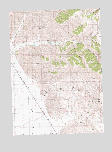
Seamans Creek, ID USGS Topographic Map
Click on map above to begin viewing in our Map Viewer.

This topographic map contains these locations and features:
Feature Name Type Latitude Longitude GNIS ID View Map
Aspen SpringSpringN43.4082°W114.1280°371301View Map
BalaamLocaleN43.4107°W114.2178°399435View Map
Barrel SpringsSpringN43.4197°W114.1832°371372View Map
Bellevue CemeteryCemeteryN43.4599°W114.2478°371444View Map
Big Dry CanyonValleyN43.4702°W114.1698°371495View Map
Canal Number 45CanalN43.4099°W114.2275°376332View Map
Chukar CreekStreamN43.4177°W114.1659°372022View Map
Cove CreekStreamN43.3902°W114.1748°372187View Map
Cove SpringSpringN43.3955°W114.1448°372189View Map
Crooked CanyonValleyN43.4688°W114.1403°372261View Map
District Canal Forty-FiveCanalN43.4116°W114.2275°395308View Map
Dry CreekStreamN43.3888°W114.1878°372465View Map
Elk SpringSpringN43.4045°W114.1321°372609View Map
Hailey-Bellevue DivisionCivilN43.4590°W114.2017°1936726View Map
Italian GulchValleyN43.4705°W114.1398°373261View Map
Italian SpringSpringN43.4863°W114.1370°373262View Map
Jasper FlatsFlatN43.3841°W114.1300°373351View Map
Lookout MountainSummitN43.4466°W114.2159°397872View Map
Martin CanyonValleyN43.4694°W114.2123°373842View Map
McFates CanyonValleyN43.4671°W114.1612°373875View Map
North Fork Chukar CreekStreamN43.4216°W114.1514°374191View Map
North Fork Cove CreekStreamN43.4038°W114.1398°374193View Map
Rattlesnake CanyonValleyN43.4121°W114.2081°374583View Map
Seamans CreekStreamN43.4549°W114.2445°374940View Map
Shady SpringSpringN43.4062°W114.1284°374963View Map
Sharps CanyonValleyN43.4669°W114.1462°374969View Map

Note: Coordinates in the location and feature list above are referenced to NAD83 datum.


Copyright (C) 2008-2024 Ryan Niemi / Sunset Dynamics ... All Rights Reserved