TopoQuest Logo
Do you find TopoQuest useful?
Help keep TopoQuest running and adding new maps/features by donating!
Bitcoin:  19c7KJd3qBynnjoSw5npx9KScwjBe4ifkT
Litecoin:  LXs6TkuXGGXo1vDsWCkWVdjQX94eUKd6ui
Home View Maps Find Maps Find Places Resources & Links


Savanna, Oklahoma Topographic Map

USGS Map Title: Savanna, OK
USGS Map MRC: 34095G7
DRG (GeoTIFF) Download: o34095g7.tif


Neighboring USGS Topographic Map Quads:


  Haywood, OK  
34095H8
 

  McAlester, OK  
34095H7
 

  Krebs, OK  
34095H6
 

  McAlester SW, OK  
34095G8
 

  Savanna, OK  
34095G7
 

  Hartshorne SW, OK  
34095G6
 

  Kiowa, OK  
34095F8
 

  Pittsburg, OK  
34095F7
 

  Ti, OK  
34095F6


Map MRC Location:

N35°
W96°
N35°
W95°
H8 H7 H6 H5 H4 H3 H2 H1
G8 G7 G6 G5 G4 G3 G2 G1
F8 F7 F6 F5 F4 F3 F2 F1
E8 E7 E6 E5 E4 E3 E2 E1
D8 D7 D6 D5 D4 D3 D2 D1
C8 C7 C6 C5 C4 C3 C2 C1
B8 B7 B6 B5 B4 B3 B2 B1
A8 A7 A6 A5 A4 A3 A2 A1
N34°
W96°
N34°
W95°

Savanna, OK USGS 1:24K Topographic Map Preview:
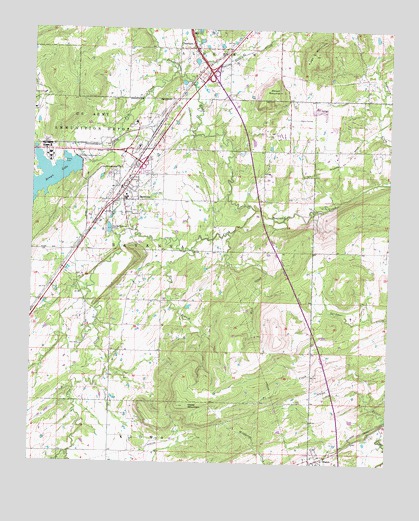
Savanna, OK USGS Topographic Map
Click on map above to begin viewing in our Map Viewer.

This topographic map contains these locations and features:
Feature Name Type Latitude Longitude GNIS ID View Map
BlancoPopulated PlaceN34.7512°W95.7744°1090251View Map
Blanco CemeteryCemeteryN34.7528°W95.7678°2712528View Map
Blanco Census Designated PlaceCensusN34.7507°W95.7736°2629908View Map
Blanco Fire DepartmentBuildingN34.7510°W95.7762°2657331View Map
BrewerPopulated PlaceN34.8132°W95.8608°1763743View Map
Brown Lake DamDamN34.8360°W95.8580°1754458View Map
Brushy Peaceable Creek Site 31 DamDamN34.8084°W95.7953°1752311View Map
Brushy Peaceable Creek Site 32 DamDamN34.7934°W95.8236°1752313View Map
Brushy Peaceable Creek Site 32 ReservoirReservoirN34.7931°W95.8230°1752314View Map
Brushy Peaceable Creek Site 33 DamDamN34.7751°W95.8453°1752315View Map
Brushy Peaceable Creek Site 33 ReservoirReservoirN34.7758°W95.8444°1752316View Map
Bull CreekStreamN34.8623°W95.8255°1090671View Map
Burshy Peaceable Creek Site 31 ReservoirReservoirN34.8070°W95.7945°1752312View Map
ChambersPopulated PlaceN34.8698°W95.8247°1091195View Map
Chambers CemeteryCemeteryN34.8676°W95.8188°2712529View Map
Chun CreekStreamN34.8229°W95.7967°1091357View Map
Dancing Rabbit CreekStreamN34.8604°W95.8205°1091930View Map
HalleyPopulated PlaceN34.8520°W95.8367°1763742View Map
McAlester Army Ammo Plant Fire DepartmentBuildingN34.8394°W95.8670°2656901View Map
Piney BranchStreamN34.8115°W95.8194°1096674View Map
Piney MountainSummitN34.8682°W95.7775°1096680View Map
Rock CreekStreamN34.8162°W95.8067°1097283View Map
SavannaPopulated PlaceN34.8290°W95.8439°1097851View Map
Savanna CemeteryCemeteryN34.8222°W95.8397°2712533View Map
Savanna Elementary SchoolSchoolN34.8265°W95.8420°1790756View Map
Savanna Fire DepartmentBuildingN34.8322°W95.8393°2656952View Map
Savanna High SchoolSchoolN34.8265°W95.8420°1790460View Map
Shoat MountainSummitN34.8579°W95.7944°1098010View Map
Town of SavannaCivilN34.8353°W95.8358°2413262View Map
Township of SavannaCivilN34.8126°W95.8336°1824649View Map
Wade MountainSummitN34.7665°W95.8228°1099284View Map

Note: Coordinates in the location and feature list above are referenced to NAD83 datum.


Copyright (C) 2008-2024 Ryan Niemi / Sunset Dynamics ... All Rights Reserved