TopoQuest Logo
Do you find TopoQuest useful?
Help keep TopoQuest running and adding new maps/features by donating!
Bitcoin:  19c7KJd3qBynnjoSw5npx9KScwjBe4ifkT
Litecoin:  LXs6TkuXGGXo1vDsWCkWVdjQX94eUKd6ui
Home View Maps Find Maps Find Places Resources & Links


Sardis, South Carolina Topographic Map

USGS Map Title: Sardis, SC
USGS Map MRC: 34079A8
DRG (GeoTIFF) Download: o34079a8.tif


Neighboring USGS Topographic Map Quads:


  Lamar, SC  
34080B1
 

  Timmonsville, SC  
34079B8
 

  Florence West, SC  
34079B7
 

  Lynchburg, SC  
34080A1
 

  Sardis, SC  
34079A8
 

  Effingham, SC  
34079A7
 

  Turbeville, SC  
33080H1
 

  Olanta, SC  
33079H8
 

  Mill Bay, SC  
33079H7


Map MRC Location:

N35°
W80°
N35°
W79°
H8 H7 H6 H5 H4 H3 H2 H1
G8 G7 G6 G5 G4 G3 G2 G1
F8 F7 F6 F5 F4 F3 F2 F1
E8 E7 E6 E5 E4 E3 E2 E1
D8 D7 D6 D5 D4 D3 D2 D1
C8 C7 C6 C5 C4 C3 C2 C1
B8 B7 B6 B5 B4 B3 B2 B1
A8 A7 A6 A5 A4 A3 A2 A1
N34°
W80°
N34°
W79°

Sardis, SC USGS 1:24K Topographic Map Preview:
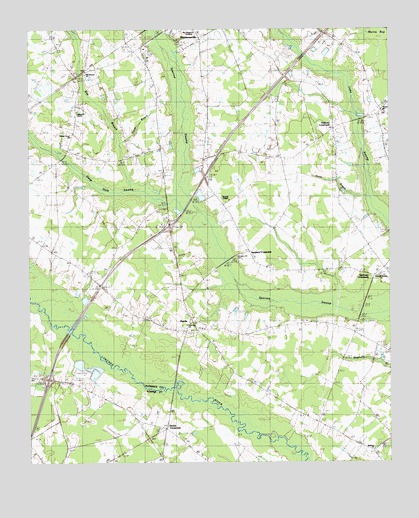
Sardis, SC USGS Topographic Map
Click on map above to begin viewing in our Map Viewer.

This topographic map contains these locations and features:
Feature Name Type Latitude Longitude GNIS ID View Map
Aimwell ChurchChurchN34.0057°W79.9540°1244438View Map
Antioch ChurchChurchN34.0913°W79.8998°1244901View Map
Bay BranchStreamN34.0790°W79.9628°1220369View Map
Bay Branch ChurchChurchN34.1121°W79.9801°1242309View Map
Bethany ChurchChurchN34.0040°W79.8809°1246762View Map
Brownwood School (historical)SchoolN34.0221°W79.8859°1247027View Map
Center SchoolSchoolN34.0882°W79.9156°1221479View Map
Center School (historical)SchoolN34.0927°W79.8998°1242351View Map
Chaney Grove ChurchChurchN34.0943°W79.9851°1241814View Map
China Grove ChurchChurchN34.0899°W79.9862°1221570View Map
China Grove School (historical)SchoolN34.1015°W79.9826°1247286View Map
Deep Hole SwampStreamN34.0754°W79.9462°1221982View Map
Deliverance TabernacleChurchN34.1123°W79.9585°2490086View Map
Fellowship Church of God HolinessChurchN34.1014°W79.9831°1241877View Map
Hobbs CrossroadsPopulated PlaceN34.0099°W79.9528°1246003View Map
Hollman CrossroadsPopulated PlaceN34.0960°W79.8931°1227918View Map
Horse BranchStreamN34.0763°W79.8817°1223302View Map
Howard ChapelChurchN34.0757°W79.9303°1246082View Map
Hudson BridgeBridgeN34.0215°W79.9501°1246090View Map
Humphrey ChapelChurchN34.0507°W79.9756°1223391View Map
Humphrey LakeLakeN34.0440°W79.9837°1223392View Map
Interchange 146CrossingN34.0243°W79.9931°1228324View Map
Interchange 150CrossingN34.0685°W79.9512°1228325View Map
Jack LakeLakeN34.0278°W79.9773°1223481View Map
Kelly LakeLakeN34.0332°W79.9840°1223710View Map
Mc Kay AirportAirportN34.1115°W79.9027°1251979View Map
Morrell SchoolSchoolN34.1118°W79.9798°1224649View Map
New Home School (historical)SchoolN34.0879°W79.9667°1242087View Map
New Zion ChurchChurchN34.0402°W79.9440°1242090View Map
Peniel ChurchChurchN34.1015°W79.8765°1250057View Map
Pleasant View (historical)Populated PlaceN34.1213°W79.9656°1242132View Map
Poplar BranchStreamN34.0921°W79.9678°1225617View Map
Roy Hudgens AcademySchoolN34.1243°W79.9420°1242155View Map
Saint Johns ChurchChurchN34.0068°W79.9865°1250549View Map
Sansbury CrossroadsPopulated PlaceN34.0607°W79.9231°1226393View Map
Sansbury Hill CemeteryCemeteryN34.0596°W79.9276°1242183View Map
SardisPopulated PlaceN34.0404°W79.9440°1231778View Map
Sardis - Timmonsville Fire DepartmentBuildingN34.0562°W79.8915°2578278View Map
Sardis - Timmonsville Fire DepartmentBuildingN34.0897°W79.9543°2578650View Map
Sardis Baptist ChurchChurchN34.0388°W79.9392°1242184View Map
Sardis DivisionCivilN34.0563°W79.9442°1938417View Map
Scotts Mill (historical)LocaleN34.0882°W79.9892°1242189View Map
Sparrow Swamp CemeteryCemeteryN34.0543°W79.8770°1242205View Map
Sparrow Swamp ChurchChurchN34.0535°W79.8762°1250981View Map
Sparrows CrossroadsPopulated PlaceN34.0540°W79.8798°1242204View Map
Timmonsville DivisionCivilN34.0913°W79.9135°1938443View Map

Note: Coordinates in the location and feature list above are referenced to NAD83 datum.


Copyright (C) 2008-2024 Ryan Niemi / Sunset Dynamics ... All Rights Reserved