TopoQuest Logo
Do you find TopoQuest useful?
Help keep TopoQuest running and adding new maps/features by donating!
Bitcoin:  19c7KJd3qBynnjoSw5npx9KScwjBe4ifkT
Litecoin:  LXs6TkuXGGXo1vDsWCkWVdjQX94eUKd6ui
Home View Maps Find Maps Find Places Resources & Links


Sandborn, Indiana Topographic Map

USGS Map Title: Sandborn, IN
USGS Map MRC: 38087H2
DRG (GeoTIFF) Download: o38087h2.tif


Neighboring USGS Topographic Map Quads:


  Dugger, IN  
39087A3
 

  Linton, IN  
39087A2
 

  Switz City, IN  
39087A1
 

  Bucktown, IN  
38087H3
 

  Sandborn, IN  
38087H2
 

  Lyons, IN  
38087H1
 

  Bicknell, IN  
38087G3
 

  Plainville, IN  
38087G2
 

  Epsom, IN  
38087G1


Map MRC Location:

N39°
W88°
N39°
W87°
H8 H7 H6 H5 H4 H3 H2 H1
G8 G7 G6 G5 G4 G3 G2 G1
F8 F7 F6 F5 F4 F3 F2 F1
E8 E7 E6 E5 E4 E3 E2 E1
D8 D7 D6 D5 D4 D3 D2 D1
C8 C7 C6 C5 C4 C3 C2 C1
B8 B7 B6 B5 B4 B3 B2 B1
A8 A7 A6 A5 A4 A3 A2 A1
N38°
W88°
N38°
W87°

Sandborn, IN USGS 1:24K Topographic Map Preview:
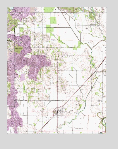
Sandborn, IN USGS Topographic Map
Click on map above to begin viewing in our Map Viewer.

This topographic map contains these locations and features:
Feature Name Type Latitude Longitude GNIS ID View Map
Armuth DitchCanalN38.9181°W87.1445°430266View Map
Begeman CemeteryCemeteryN38.8823°W87.2347°430746View Map
Bethel ChurchChurchN38.9195°W87.2161°430921View Map
Black Creek DitchCanalN38.9862°W87.1650°431132View Map
Brewer DitchCanalN38.9687°W87.1872°431495View Map
Burris ChapelChurchN38.9873°W87.2300°431869View Map
Calico Slash DitchCanalN38.9298°W87.1625°431961View Map
Cane Green BottomBasinN38.9000°W87.2295°432104View Map
Delay CemeteryCemeteryN38.8989°W87.2050°433455View Map
Goose Pond (historical)SwampN38.9764°W87.1775°448388View Map
Greene-Sullivan State ForestForestN38.9862°W87.2436°435435View Map
Hamilton DitchCanalN38.9814°W87.1714°435641View Map
Hill DitchCanalN38.9064°W87.1961°436192View Map
MarcoPopulated PlaceN38.9359°W87.1422°438599View Map
Marco CemeteryCemeteryN38.9361°W87.1328°438600View Map
McGinnis LeveeLeveeN38.8806°W87.1261°438875View Map
Neal LeveeLeveeN38.8914°W87.1345°439956View Map
Pleasant Grove ChurchChurchN38.9823°W87.1389°441257View Map
SandbornPopulated PlaceN38.8964°W87.1867°442991View Map
Sandborn CemeteryCemeteryN38.8970°W87.1697°442992View Map
Sandborn Volunteer Fire DepartmentBuildingN38.8960°W87.1865°2625880View Map
Singer DitchCanalN38.8934°W87.2239°443546View Map
Singer Ditch DamDamN38.9270°W87.2300°447274View Map
Spencer CreekStreamN38.9795°W87.2217°443941View Map
Stafford ChurchChurchN38.9484°W87.1870°444045View Map
Town of SandbornCivilN38.8968°W87.1846°2396904View Map
Township of StaffordCivilN38.9512°W87.1852°453869View Map

Note: Coordinates in the location and feature list above are referenced to NAD83 datum.


Copyright (C) 2008-2024 Ryan Niemi / Sunset Dynamics ... All Rights Reserved