TopoQuest Logo
Do you find TopoQuest useful?
Help keep TopoQuest running and adding new maps/features by donating!
Bitcoin:  19c7KJd3qBynnjoSw5npx9KScwjBe4ifkT
Litecoin:  LXs6TkuXGGXo1vDsWCkWVdjQX94eUKd6ui
Home View Maps Find Maps Find Places Resources & Links


San Juan, New Mexico Topographic Map

USGS Map Title: San Juan, NM
USGS Map MRC: 35105B3
DRG (GeoTIFF) Download: o35105b3.tif


Neighboring USGS Topographic Map Quads:


  Sena, NM  
35105C4
 

  Villanueva, NM  
35105C3
 

  Apache Springs, NM  
35105C2
 

  Aurora, NM  
35105B4
 

  San Juan, NM  
35105B3
 

  Anton Chico, NM  
35105B2
 

  Jacinto Mesa, NM  
35105A4
 

  Potrillo Hill, NM  
35105A3
 

  Mesa Palo Amarillo, NM  
35105A2


Map MRC Location:

N36°
W106°
N36°
W105°
H8 H7 H6 H5 H4 H3 H2 H1
G8 G7 G6 G5 G4 G3 G2 G1
F8 F7 F6 F5 F4 F3 F2 F1
E8 E7 E6 E5 E4 E3 E2 E1
D8 D7 D6 D5 D4 D3 D2 D1
C8 C7 C6 C5 C4 C3 C2 C1
B8 B7 B6 B5 B4 B3 B2 B1
A8 A7 A6 A5 A4 A3 A2 A1
N35°
W106°
N35°
W105°

San Juan, NM USGS 1:24K Topographic Map Preview:
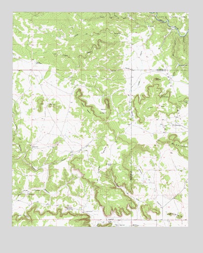
San Juan, NM USGS Topographic Map
Click on map above to begin viewing in our Map Viewer.

This topographic map contains these locations and features:
Feature Name Type Latitude Longitude GNIS ID View Map
Arroyo ChimajaValleyN35.1467°W105.3536°903370View Map
Arroyo HondoValleyN35.2192°W105.2842°903388View Map
Arroyo SanchezValleyN35.1676°W105.3681°903415View Map
Caņada de la CabraStreamN35.1609°W105.3497°904335View Map
Caņada SeguraStreamN35.2481°W105.2736°904481View Map
Caņon de CalosoValleyN35.2381°W105.2583°904571View Map
Caņon de la DamianaValleyN35.2389°W105.2508°904511View Map
Caņon de la MinaValleyN35.2481°W105.2745°904519View Map
Caņon de los MaderosValleyN35.2425°W105.2814°904530View Map
Caņon de OjitoValleyN35.1306°W105.2842°904586View Map
Caņon de PadreValleyN35.1284°W105.3045°904594View Map
Cedar HillPopulated PlaceN35.2437°W105.2672°912557View Map
Ciruela MesaSummitN35.1950°W105.2783°905172View Map
Dahlia ChurchChurchN35.1256°W105.3006°905578View Map
Domingo RanchLocaleN35.1712°W105.3614°905813View Map
El AguilaSummitN35.1984°W105.3089°906026View Map
El CaņoncitoValleyN35.2362°W105.2536°906038View Map
El Cerrito Santa CruzSummitN35.1362°W105.3372°906042View Map
El Fileto CaņonValleyN35.2481°W105.2745°906049View Map
El Fileto RuinsLocaleN35.2445°W105.2772°906050View Map
El ToroSummitN35.1326°W105.2625°906101View Map
El Viandante RuinsLocaleN35.2406°W105.2617°906108View Map
Empedrado TankReservoirN35.2194°W105.2579°906158View Map
J T Gallegos RanchLocaleN35.1445°W105.3639°907277View Map
La Cabra MesaSummitN35.1826°W105.3086°907608View Map
La Gotera WellWellN35.1612°W105.3053°907645View Map
Laguana del GallegoLakeN35.2204°W105.3595°907742View Map
Las LagunitasStreamN35.2045°W105.2914°907872View Map
Leandro RanchChurchN35.1259°W105.2997°907914View Map
Los CerritosSummitN35.1984°W105.3561°908199View Map
Los Cerritos del ToroRidgeN35.1320°W105.2589°908202View Map
Los MontecitosAreaN35.1845°W105.2636°908217View Map
Mesa de la ChamizalosaSummitN35.1714°W105.2542°908602View Map
Mesa SeguraSummitN35.1970°W105.3250°908637View Map
Palo DurosoValleyN35.2473°W105.3014°902913View Map
Quintana RanchLocaleN35.1337°W105.3231°909944View Map
Rincon de la CiruelitaAreaN35.2014°W105.2703°910177View Map
Rincon de ZixtoAreaN35.1323°W105.3672°910182View Map
Rincon del AguilaAreaN35.1925°W105.3114°910183View Map
Romero RanchLocaleN35.2420°W105.2795°910421View Map
San JuanPopulated PlaceN35.1456°W105.3656°910643View Map
San Juan CemeteryCemeteryN35.1456°W105.3650°931226View Map
Sisneros RanchLocaleN35.1251°W105.2656°894876View Map
Tierra ColoradaSummitN35.2112°W105.2742°911703View Map

Note: Coordinates in the location and feature list above are referenced to NAD83 datum.


Copyright (C) 2008-2024 Ryan Niemi / Sunset Dynamics ... All Rights Reserved