TopoQuest Logo
Do you find TopoQuest useful?
Help keep TopoQuest running and adding new maps/features by donating!
Bitcoin:  19c7KJd3qBynnjoSw5npx9KScwjBe4ifkT
Litecoin:  LXs6TkuXGGXo1vDsWCkWVdjQX94eUKd6ui
Home View Maps Find Maps Find Places Resources & Links


Birch Creek, Michigan Topographic Map

USGS Map Title: Birch Creek, MI
USGS Map MRC: 45087B5
DRG (GeoTIFF) Download: o45087b5.tif


Neighboring USGS Topographic Map Quads:


  McAllister, WI  
45087C6
 

  Wallace, MI  
45087C5
 

  Arthur Bay, MI  
45087C4
 

  Chappee Rapids, MI  
45087B6
 

  Birch Creek, MI  
45087B5
 

  Chambers Island NW, WI  
45087B4
 

  Marinette West, WI  
45087A6
 

  Marinette East, WI  
45087A5
 

  Green Island, WI  
45087A4


Map MRC Location:

N46°
W88°
N46°
W87°
H8 H7 H6 H5 H4 H3 H2 H1
G8 G7 G6 G5 G4 G3 G2 G1
F8 F7 F6 F5 F4 F3 F2 F1
E8 E7 E6 E5 E4 E3 E2 E1
D8 D7 D6 D5 D4 D3 D2 D1
C8 C7 C6 C5 C4 C3 C2 C1
B8 B7 B6 B5 B4 B3 B2 B1
A8 A7 A6 A5 A4 A3 A2 A1
N45°
W88°
N45°
W87°

Birch Creek, MI USGS 1:24K Topographic Map Preview:
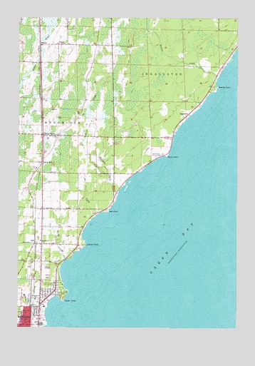
Birch Creek, MI USGS Topographic Map
Click on map above to begin viewing in our Map Viewer.

This topographic map contains these locations and features:
Feature Name Type Latitude Longitude GNIS ID View Map
Bayside Mobile EstatesPopulated PlaceN45.1297°W87.6106°2352804View Map
Beattie CreekStreamN45.2269°W87.5104°620889View Map
Beattie PointCapeN45.2222°W87.5115°620890View Map
Birch CreekPopulated PlaceN45.2028°W87.6112°621398View Map
Birch CreekStreamN45.1836°W87.5737°621399View Map
Birch Creek CemeteryCemeteryN45.2028°W87.6033°2353272View Map
Bis CreekStreamN45.1716°W87.5765°621450View Map
Crestview Adult Care HomeHospitalN45.1717°W87.5806°2352785View Map
Eagles NestPopulated PlaceN45.1905°W87.6115°1617535View Map
Emmanuel Lutheran ChurchChurchN45.1253°W87.6189°2352795View Map
Evergreen SchoolSchoolN45.1600°W87.6123°625715View Map
Grant SchoolSchoolN45.1336°W87.6176°627160View Map
Hall PointCapeN45.1716°W87.5740°627652View Map
HansenPopulated PlaceN45.2394°W87.6132°1617607View Map
Hay CreekStreamN45.1322°W87.6093°627971View Map
Hill CreekStreamN45.2108°W87.5871°628276View Map
Holy Trinity ChurchChurchN45.2022°W87.6029°628499View Map
IngallstonPopulated PlaceN45.2114°W87.5276°1617640View Map
Ingallston Post Office (historical)Post OfficeN45.2114°W87.5275°2353168View Map
Jehovah's WitnessesChurchN45.1403°W87.6117°2352791View Map
John Henes ParkParkN45.1386°W87.5993°629309View Map
Juttner PointCapeN45.1583°W87.5871°629428View Map
KewPopulated PlaceN45.1586°W87.6159°629639View Map
Menominee Church of ChristChurchN45.1428°W87.6122°2352792View Map
Menominee Ingallston Townships Volunteer Fire DepartmentBuildingN45.2415°W87.6129°2626720View Map
North Shore Baptist ChurchChurchN45.1428°W87.6056°2352799View Map
North Shore Country ClubLocaleN45.1947°W87.5440°1623533View Map
Poplar PointCapeN45.1364°W87.5996°635244View Map
Saint Williams SchoolSchoolN45.1364°W87.6154°637095View Map
Spangle SchoolSchoolN45.2394°W87.5993°638466View Map
Springer CreekStreamN45.1814°W87.5662°638621View Map
Stony PointCapeN45.1944°W87.5404°638918View Map
Turtle CreekStreamN45.1514°W87.5987°1615197View Map
Utopia CreekStreamN45.1519°W87.5996°1615438View Map
Watertower ParkParkN45.1317°W87.6233°2352810View Map

Note: Coordinates in the location and feature list above are referenced to NAD83 datum.


Copyright (C) 2008-2024 Ryan Niemi / Sunset Dynamics ... All Rights Reserved