TopoQuest Logo
Do you find TopoQuest useful?
Help keep TopoQuest running and adding new maps/features by donating!
Bitcoin:  19c7KJd3qBynnjoSw5npx9KScwjBe4ifkT
Litecoin:  LXs6TkuXGGXo1vDsWCkWVdjQX94eUKd6ui
Home View Maps Find Maps Find Places Resources & Links


Salvisa, Kentucky Topographic Map

USGS Map Title: Salvisa, KY
USGS Map MRC: 37084H7
DRG (GeoTIFF) Download: o37084h7.tif


Neighboring USGS Topographic Map Quads:


  Alton Station, KY  
38084A8
 

  Tyrone, KY  
38084A7
 

  Versailles, KY  
38084A6
 

  McBrayer, KY  
37084H8
 

  Salvisa, KY  
37084H7
 

  Keene, KY  
37084H6
 

  Cornishville, KY  
37084G8
 

  Harrodsburg, KY  
37084G7
 

  Wilmore, KY  
37084G6


Map MRC Location:

N38°
W85°
N38°
W84°
H8 H7 H6 H5 H4 H3 H2 H1
G8 G7 G6 G5 G4 G3 G2 G1
F8 F7 F6 F5 F4 F3 F2 F1
E8 E7 E6 E5 E4 E3 E2 E1
D8 D7 D6 D5 D4 D3 D2 D1
C8 C7 C6 C5 C4 C3 C2 C1
B8 B7 B6 B5 B4 B3 B2 B1
A8 A7 A6 A5 A4 A3 A2 A1
N37°
W85°
N37°
W84°

Salvisa, KY USGS 1:24K Topographic Map Preview:
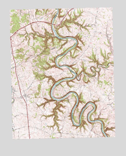
Salvisa, KY USGS Topographic Map
Click on map above to begin viewing in our Map Viewer.

This topographic map contains these locations and features:
Feature Name Type Latitude Longitude GNIS ID View Map
Allen CemeteryCemeteryN37.9409°W84.7611°485863View Map
BondvillePopulated PlaceN37.9217°W84.8719°487657View Map
Bondville Post Office (historical)Post OfficeN37.9219°W84.8713°2566012View Map
Brushy RunStreamN37.8801°W84.7636°488152View Map
Camp OtonkLocaleN37.9437°W84.8049°488710View Map
Chapman BendBendN37.9066°W84.7771°2566023View Map
Clay Lick ChurchChurchN37.9548°W84.8508°489581View Map
Clay Lick CreekStreamN37.9734°W84.8241°489583View Map
Clear CreekStreamN37.9362°W84.7961°489614View Map
Cottage Home Farm (historical)LocaleN37.9744°W84.7878°2558137View Map
Craig CreekStreamN37.9790°W84.8205°490271View Map
Cummins Ferry (historical)Populated PlaceN37.8819°W84.7797°2566028View Map
Cummins Ferry (historical)CrossingN37.8910°W84.7715°2566029View Map
Daniel Brewers Mill (historical)LocaleN37.8840°W84.8735°2566032View Map
EbenezerPopulated PlaceN37.8798°W84.8149°491533View Map
Ebenezer Church CemeteryCemeteryN37.8806°W84.8152°2566039View Map
Ebenezer Church of Christ (historical)ChurchN37.8805°W84.8156°2566040View Map
Ebenezer Post Office (historical)Post OfficeN37.8790°W84.8158°2566041View Map
Gilbert CreekStreamN37.9734°W84.8188°492818View Map
Gray CemeteryCemeteryN37.9506°W84.7919°493197View Map
Hawkins CemeteryCemeteryN37.9570°W84.8202°493891View Map
Hebron ChurchChurchN37.9634°W84.8750°493992View Map
Hillsborough ChurchChurchN37.9831°W84.7719°494275View Map
Houchin (historical)Populated PlaceN37.9712°W84.8379°2566547View Map
Landing RunStreamN37.9112°W84.8192°495956View Map
Lillards Ferry (historical)LocaleN37.9706°W84.7965°2558119View Map
Lillards SpringSpringN37.9642°W84.8732°2555304View Map
Lock Number 6DamN37.9262°W84.8210°517228View Map
McCalls Spring Historical MarkerParkN37.9657°W84.8743°2744162View Map
McCouns Ferry (historical)LocaleN37.9497°W84.8191°2558135View Map
Morris CemeteryCemeteryN37.9834°W84.7755°498617View Map
MortonsvillePopulated PlaceN37.9720°W84.7563°498647View Map
Mortonsville Elementary School (historical)SchoolN37.9718°W84.7563°2558136View Map
Mortonsville Post Office (historical)Post OfficeN37.9745°W84.7570°2558138View Map
Mount Edwin ChurchChurchN37.9320°W84.7711°498723View Map
New Providence Presbyterian Church (historical)ChurchN37.9127°W84.8239°2566067View Map
NonesuchPopulated PlaceN37.9062°W84.7555°499515View Map
Nonesuch Post Office (historical)Post OfficeN37.9065°W84.7548°2558131View Map
Nonesuch SchoolSchoolN37.9106°W84.7563°499516View Map
OregonPopulated PlaceN37.9123°W84.8236°499992View Map
Oregon BendBendN37.9177°W84.8254°2558134View Map
SalvisaPopulated PlaceN37.9167°W84.8577°502854View Map
Salvisa Census Designated PlaceCensusN37.9210°W84.8615°2629677View Map
Salvisa Fire DepartmentBuildingN37.9172°W84.8584°2637087View Map
Salvisa Railroad Station (historical)LocaleN37.9224°W84.8723°2566077View Map
Salvisa SchoolSchoolN37.9156°W84.8633°502855View Map
Scotts Ferry (historical)CrossingN37.9736°W84.8197°2566568View Map
Sellers Mill (historical)LocaleN37.9067°W84.7540°2558132View Map
Tanners CreekStreamN37.9423°W84.7591°504941View Map
The Polk Memorial Church CemeteryCemeteryN37.9746°W84.7564°2558139View Map
Warwick Ferry (historical)CrossingN37.9131°W84.8222°2566089View Map
Warwick Post Office (historical)Post OfficeN37.9142°W84.8197°2558133View Map
Willhoyt CemeteryCemeteryN37.9470°W84.8097°506778View Map
Woodford County Fire Department Station 3BuildingN37.9072°W84.7554°2637081View Map
Woodford County Fire Department Station 5BuildingN37.9703°W84.7537°2637080View Map

Note: Coordinates in the location and feature list above are referenced to NAD83 datum.


Copyright (C) 2008-2024 Ryan Niemi / Sunset Dynamics ... All Rights Reserved