TopoQuest Logo
Do you find TopoQuest useful?
Help keep TopoQuest running and adding new maps/features by donating!
Bitcoin:  19c7KJd3qBynnjoSw5npx9KScwjBe4ifkT
Litecoin:  LXs6TkuXGGXo1vDsWCkWVdjQX94eUKd6ui
Home View Maps Find Maps Find Places Resources & Links


Salter Path, North Carolina Topographic Map

USGS Map Title: Salter Path, NC
USGS Map MRC: 34076F8
DRG (GeoTIFF) Download: o34076f8.tif


Neighboring USGS Topographic Map Quads:


  Hadnot Creek, NC  
34077G1
 

  Masontown, NC  
34076G8
 

  Newport, NC  
34076G7
 

  Swansboro, NC  
34077F1
 

  Salter Path, NC  
34076F8
 

  Mansfield, NC  
34076F7


Map MRC Location:

N35°
W77°
N35°
W76°
H8 H7 H6 H5 H4 H3 H2 H1
G8 G7 G6 G5 G4 G3 G2 G1
F8 F7 F6 F5 F4 F3 F2 F1
E8 E7 E6 E5 E4 E3 E2 E1
D8 D7 D6 D5 D4 D3 D2 D1
C8 C7 C6 C5 C4 C3 C2 C1
B8 B7 B6 B5 B4 B3 B2 B1
A8 A7 A6 A5 A4 A3 A2 A1
N34°
W77°
N34°
W76°

Salter Path, NC USGS 1:24K Topographic Map Preview:
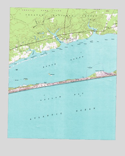
Salter Path, NC USGS Topographic Map
Click on map above to begin viewing in our Map Viewer.

This topographic map contains these locations and features:
Feature Name Type Latitude Longitude GNIS ID View Map
Bean IslandIslandN34.6804°W76.9927°1008974View Map
Bogue SoundBayN34.6966°W76.9358°1009528View Map
Broad and Gales Creek Rescue SquadBuildingN34.7254°W76.9392°2720628View Map
Broad and Gales Creek Volunteer Fire DepartmentBuildingN34.7253°W76.9393°2639689View Map
Broad CreekPopulated PlaceN34.7207°W76.9363°1019307View Map
Broad CreekStreamN34.7152°W76.9369°1009623View Map
Broad Creek Census Designated PlaceCensusN34.7304°W76.9241°2628615View Map
Broad Creek Middle SchoolSchoolN34.7349°W76.9144°1024933View Map
Cat IslandIslandN34.6863°W76.9708°1017503View Map
Circle P Farm AirportAirportN34.7485°W76.9095°2679235View Map
Dog IslandsIslandN34.6946°W76.9066°1010856View Map
East Prong Broad CreekStreamN34.7252°W76.9477°1010999View Map
East Prong Gales CreekStreamN34.7390°W76.9074°1011000View Map
Emerald IslePopulated PlaceN34.6779°W76.9508°1020148View Map
Emerald Isle Fire Department Station 2BuildingN34.6771°W76.9581°2639697View Map
FoxlairPopulated PlaceN34.7407°W76.9297°1024932View Map
Gales CreekStreamN34.7246°W76.9011°1011427View Map
Hannah BranchStreamN34.7341°W76.9655°1011840View Map
Indian BeachPopulated PlaceN34.6866°W76.8952°1017958View Map
Indian BeachBeachN34.6899°W76.8905°1018128View Map
Indian Beach Police DepartmentBuildingN34.6877°W76.8902°2130881View Map
Long IslandIslandN34.6810°W76.9805°1013160View Map
Lovett IslandIslandN34.6907°W76.9927°1013214View Map
OceanPopulated PlaceN34.7118°W76.9913°1021716View Map
Paradise Bay Mobile Home ParkPopulated PlaceN34.6888°W76.8923°2505539View Map
Patsy PondLakeN34.7261°W76.9619°1014250View Map
Rices PathLocaleN34.6824°W76.9183°1014847View Map
Rock PointCapeN34.6907°W76.8944°1015001View Map
Rollingwoood AcresPopulated PlaceN34.7291°W76.9483°1024934View Map
Saint Francis by the Sea Episcopal ChurchChurchN34.6895°W76.8777°2646498View Map
Salter PathPopulated PlaceN34.6885°W76.8861°1027455View Map
Salter Path Volunteer Fire Department and Emergency Medical ServicesBuildingN34.6875°W76.8905°2638861View Map
Sanders CreekBayN34.7071°W76.9705°1015221View Map
Sandy BranchStreamN34.7332°W76.9680°1015227View Map
Sikes BranchStreamN34.7096°W76.9727°1015511View Map
Sikes Branch East ProngStreamN34.7096°W76.9727°1015512View Map
Soundview ChurchChurchN34.7324°W76.8844°1015676View Map
Town of Indian BeachCivilN34.6899°W76.8999°2405884View Map
West Prong Broad CreekStreamN34.7252°W76.9474°1016547View Map
Wolf BranchStreamN34.7349°W76.9608°1016765View Map
Wood IslandIslandN34.6863°W76.9522°1016807View Map
Yellow Hill LandingLocaleN34.6779°W76.9574°1023341View Map

Note: Coordinates in the location and feature list above are referenced to NAD83 datum.


Copyright (C) 2008-2024 Ryan Niemi / Sunset Dynamics ... All Rights Reserved