TopoQuest Logo
Do you find TopoQuest useful?
Help keep TopoQuest running and adding new maps/features by donating!
Bitcoin:  19c7KJd3qBynnjoSw5npx9KScwjBe4ifkT
Litecoin:  LXs6TkuXGGXo1vDsWCkWVdjQX94eUKd6ui
Home View Maps Find Maps Find Places Resources & Links


Saint Meinrad, Indiana Topographic Map

USGS Map Title: Saint Meinrad, IN
USGS Map MRC: 38086B7
DRG (GeoTIFF) Download: o38086b7.tif


Neighboring USGS Topographic Map Quads:


  Huntingburg, IN  
38086C8
 

  Saint Anthony, IN  
38086C7
 

  Birdseye, IN  
38086C6
 

  Dale, IN  
38086B8
 

  Saint Meinrad, IN  
38086B7
 

  Bristow, IN  
38086B6
 

  Santa Claus, IN  
38086A8
 

  Fulda, IN  
38086A7
 

  Gatchel, IN  
38086A6


Map MRC Location:

N39°
W87°
N39°
W86°
H8 H7 H6 H5 H4 H3 H2 H1
G8 G7 G6 G5 G4 G3 G2 G1
F8 F7 F6 F5 F4 F3 F2 F1
E8 E7 E6 E5 E4 E3 E2 E1
D8 D7 D6 D5 D4 D3 D2 D1
C8 C7 C6 C5 C4 C3 C2 C1
B8 B7 B6 B5 B4 B3 B2 B1
A8 A7 A6 A5 A4 A3 A2 A1
N38°
W87°
N38°
W86°

Saint Meinrad, IN USGS 1:24K Topographic Map Preview:
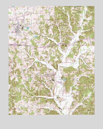
Saint Meinrad, IN USGS Topographic Map
Click on map above to begin viewing in our Map Viewer.

This topographic map contains these locations and features:
Feature Name Type Latitude Longitude GNIS ID View Map
Abbey RunStreamN38.1759°W86.8100°429982View Map
AdyevillePopulated PlaceN38.1909°W86.7694°430024View Map
Bird RunStreamN38.1923°W86.8450°431102View Map
Black RunStreamN38.1903°W86.8436°431142View Map
Blackhawk CreekStreamN38.1703°W86.8028°431152View Map
Convent of the Immaculate ConceptionSchoolN38.2253°W86.8550°432905View Map
Crooks Hollow CreekStreamN38.1445°W86.7878°450820View Map
Crooks Thom CemeteryCemeteryN38.1656°W86.7803°433172View Map
Cyclone BranchStreamN38.2137°W86.7761°433269View Map
Felmont Oil Company DamDamN38.2251°W86.8183°447238View Map
Felmont Oil Company ReservoirReservoirN38.2257°W86.8183°447237View Map
FerdinandPopulated PlaceN38.2239°W86.8622°434450View Map
Ferdinand Consolidated SchoolSchoolN38.2237°W86.8605°446621View Map
Ferdinand Old LakeReservoirN38.2267°W86.8450°448585View Map
Ferdinand Old Lake DamDamN38.2267°W86.8450°448584View Map
Ferdinand Police DepartmentBuildingN38.2246°W86.8634°2758250View Map
Ferdinand RunStreamN38.1912°W86.7958°434451View Map
Ferdinand State ForestForestN38.2231°W86.7530°450911View Map
Ferdinand Volunteer Fire Department Station 1BuildingN38.2196°W86.8617°2626532View Map
Ferdinand Volunteer Fire Department Station 2BuildingN38.2359°W86.8727°2626097View Map
Ferdinand Water Supply ReservoirReservoirN38.2151°W86.8355°447423View Map
Ferdinand Water Supply Reservoir DamDamN38.2157°W86.8334°447424View Map
Forest Park High SchoolSchoolN38.2276°W86.8578°442532View Map
Friday BranchStreamN38.2051°W86.8022°434839View Map
Hawk RunStreamN38.1951°W86.8480°435899View Map
Hurricane CreekStreamN38.1803°W86.7975°451077View Map
Interchange 63CrossingN38.2056°W86.8664°446892View Map
Lanman CemeteryCemeteryN38.1356°W86.7836°437622View Map
Meinrad HollowValleyN38.1468°W86.8107°438971View Map
Monkey Hollow DitchCanalN38.1317°W86.8133°439329View Map
Monte Cassino ShrinePopulated PlaceN38.1809°W86.8061°439353View Map
Monte RunStreamN38.1817°W86.8180°439354View Map
Nest RunStreamN38.1867°W86.8350°440000View Map
Pale RunStreamN38.2437°W86.8539°440834View Map
Rock RunStreamN38.1895°W86.7692°451401View Map
Rockhouse BranchStreamN38.1892°W86.7747°451403View Map
Saint Josephs ShrinePopulated PlaceN38.1681°W86.7978°442653View Map
Saint MeinradPopulated PlaceN38.1712°W86.8092°442728View Map
Saint Meinrad Census Designated PlaceCensusN38.1692°W86.8258°2629884View Map
Saint Meinrad College (historical)SchoolN38.1651°W86.8108°442730View Map
Saint Meinrad LakeLakeN38.1673°W86.8448°442729View Map
Saint Meinrad Volunteer Fire DepartmentBuildingN38.1672°W86.8081°2626340View Map
Stapleton CemeteryCemeteryN38.2087°W86.7539°444068View Map
Stapleton RunStreamN38.2014°W86.7583°451508View Map
Swinging CreekStreamN38.1414°W86.8055°444495View Map
Taylor CemeteryCemeteryN38.2081°W86.7728°444583View Map
Tenn Beard CemeteryCemeteryN38.1937°W86.7608°444637View Map
Till DrainStreamN38.1303°W86.7975°444759View Map
Town of FerdinandCivilN38.2265°W86.8626°2396936View Map
Township of FerdinandCivilN38.2417°W86.8519°453294View Map
Township of HarrisonCivilN38.1375°W86.8474°453396View Map
Water RunStreamN38.2434°W86.8450°445533View Map
Wind RunStreamN38.2067°W86.7819°446170View Map

Note: Coordinates in the location and feature list above are referenced to NAD83 datum.


Copyright (C) 2008-2024 Ryan Niemi / Sunset Dynamics ... All Rights Reserved