TopoQuest Logo
Do you find TopoQuest useful?
Help keep TopoQuest running and adding new maps/features by donating!
Bitcoin:  19c7KJd3qBynnjoSw5npx9KScwjBe4ifkT
Litecoin:  LXs6TkuXGGXo1vDsWCkWVdjQX94eUKd6ui
Home View Maps Find Maps Find Places Resources & Links


Saint John South, Kansas Topographic Map

USGS Map Title: Saint John South, KS
USGS Map MRC: 37098H7
DRG (GeoTIFF) Download: o37098h7.tif


Neighboring USGS Topographic Map Quads:


  Saint John SW, KS  
38098A8
 

  Saint John North, KS  
38098A7
 

  Hudson, KS  
38098A6
 

  Macksville, KS  
37098H8
 

  Saint John South, KS  
37098H7
 

  Stafford NW, KS  
37098H6
 

  Hopewell, KS  
37098G8
 

  Byers, KS  
37098G7
 

  Stafford SW, KS  
37098G6


Map MRC Location:

N38°
W99°
N38°
W98°
H8 H7 H6 H5 H4 H3 H2 H1
G8 G7 G6 G5 G4 G3 G2 G1
F8 F7 F6 F5 F4 F3 F2 F1
E8 E7 E6 E5 E4 E3 E2 E1
D8 D7 D6 D5 D4 D3 D2 D1
C8 C7 C6 C5 C4 C3 C2 C1
B8 B7 B6 B5 B4 B3 B2 B1
A8 A7 A6 A5 A4 A3 A2 A1
N37°
W99°
N37°
W98°

Saint John South, KS USGS 1:24K Topographic Map Preview:
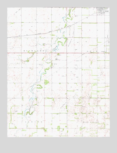
Saint John South, KS USGS Topographic Map
Click on map above to begin viewing in our Map Viewer.

This topographic map contains these locations and features:
Feature Name Type Latitude Longitude GNIS ID View Map
City of St. JohnCivilN37.9998°W98.7606°2396496View Map
Independent Order of Odd Fellows Lodge Number 539LocaleN37.9992°W98.7534°2692248View Map
Kanza Co - Operative Association Grain Elevator Number 8LocaleN37.9950°W98.7593°2695345View Map
Livingston (historical)LocaleN37.9128°W98.8565°482623View Map
Martin CemeteryCemeteryN37.9563°W98.7745°473572View Map
Neelands CemeteryCemeteryN37.9000°W98.8661°473569View Map
Our Carter (historical)LocaleN37.9858°W98.8454°482622View Map
Rattlesnake Southeast Oil FieldOilfieldN37.9708°W98.7954°473571View Map
Rattlesnake Southwest Oil FieldOilfieldN37.9097°W98.8018°473570View Map
Spring CreekStreamN37.9722°W98.8087°473568View Map
St. John Municipal Power PlantLocaleN37.9941°W98.7610°2692453View Map
Stafford County Health DepartmentBuildingN37.9992°W98.7534°2695065View Map
Township of RichlandCivilN37.9564°W98.8579°473566View Map

Note: Coordinates in the location and feature list above are referenced to NAD83 datum.


Copyright (C) 2008-2024 Ryan Niemi / Sunset Dynamics ... All Rights Reserved