TopoQuest Logo
Do you find TopoQuest useful?
Help keep TopoQuest running and adding new maps/features by donating!
Bitcoin:  19c7KJd3qBynnjoSw5npx9KScwjBe4ifkT
Litecoin:  LXs6TkuXGGXo1vDsWCkWVdjQX94eUKd6ui
Home View Maps Find Maps Find Places Resources & Links


Saguache, Colorado Topographic Map

USGS Map Title: Saguache, CO
USGS Map MRC: 38106A2
DRG (GeoTIFF) Download: o38106a2.tif


Neighboring USGS Topographic Map Quads:


  Lake Mountain NE, CO  
38106B3
 

  Klondike Mine, CO  
38106B2
 

  Graveyard Gulch, CO  
38106B1
 

  Laughlin Gulch, CO  
38106A3
 

  Saguache, CO  
38106A2
 

  Hickey Bridge, CO  
38106A1
 

  Lime Creek, CO  
37106H3
 

  Swede Corners, CO  
37106H2
 

  Harrence Lake, CO  
37106H1


Map MRC Location:

N39°
W107°
N39°
W106°
H8 H7 H6 H5 H4 H3 H2 H1
G8 G7 G6 G5 G4 G3 G2 G1
F8 F7 F6 F5 F4 F3 F2 F1
E8 E7 E6 E5 E4 E3 E2 E1
D8 D7 D6 D5 D4 D3 D2 D1
C8 C7 C6 C5 C4 C3 C2 C1
B8 B7 B6 B5 B4 B3 B2 B1
A8 A7 A6 A5 A4 A3 A2 A1
N38°
W107°
N38°
W106°

Saguache, CO USGS 1:24K Topographic Map Preview:
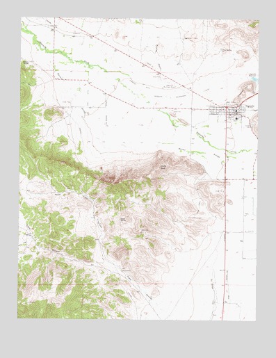
Saguache, CO USGS Topographic Map
Click on map above to begin viewing in our Map Viewer.

This topographic map contains these locations and features:
Feature Name Type Latitude Longitude GNIS ID View Map
Big Meadow DitchCanalN38.0833°W106.2056°190224View Map
Campo Santo CemeteryCemeteryN38.0880°W106.2256°190226View Map
Church In the ValleyChurchN38.0881°W106.1389°2036477View Map
Community United Methodist ChurchChurchN38.0858°W106.1397°2036489View Map
Devils KnobPillarN38.0636°W106.1767°190216View Map
Findley GulchValleyN38.0957°W106.1758°190084View Map
Flagpole HillSummitN38.0978°W106.1303°190218View Map
Fullerton Ditch 2CanalN38.0996°W106.2313°2712140View Map
Gotthelf Samora DitchCanalN38.0580°W106.1418°2712311View Map
Higgins SpringSpringN38.1060°W106.2462°190227View Map
Hillside CemeteryCemeteryN38.0816°W106.1288°190220View Map
Lawrence DitchCanalN38.0972°W106.1867°190223View Map
Malone DitchCanalN38.0754°W106.1526°2723363View Map
Morrison DitchCanalN38.1146°W106.2439°2723642View Map
Mountain Valley SchoolSchoolN38.0841°W106.1367°2025561View Map
North Saguache County Volunteer DepartmentBuildingN38.0878°W106.1367°2036479View Map
North Tracy CanyonValleyN38.0209°W106.1963°190209View Map
O'Neal SpringSpringN38.1125°W106.1455°190219View Map
Onion SpringSpringN38.0416°W106.1971°190215View Map
Pitkkin Avenue Baptist ChurchChurchN38.0839°W106.1409°2036493View Map
Reservoir Enlargement DitchCanalN38.0919°W106.1697°190222View Map
Russell Ditch 4CanalN38.0868°W106.1792°2724189View Map
Sagauache County Comprehensive Health ClinicHospitalN38.0872°W106.1375°2036487View Map
SaguachePopulated PlaceN38.0875°W106.1420°190217View Map
Saguache County CourthouseBuildingN38.0850°W106.1406°2036490View Map
Saguache County JailBuildingN38.0852°W106.1379°2036496View Map
Saguache County MuseumBuildingN38.0864°W106.1428°2036491View Map
Saguache County Sheriff's OfficeBuildingN38.0853°W106.1379°2036494View Map
Saguache DamDamN38.0992°W106.1264°201700View Map
Saguache District Ranger OfficeLocaleN38.0889°W106.1395°197149View Map
Saguache Emergency Management ServicesBuildingN38.0875°W106.1365°2695553View Map
Saguache Fire DepartmentBuildingN38.0880°W106.1362°2667258View Map
Saguache Municipal AirportAirportN38.0979°W106.1711°204574View Map
Saguache Post OfficePost OfficeN38.0878°W106.1367°2036480View Map
Saguache ReservoirReservoirN38.1003°W106.1272°169450View Map
Saguache Town HallBuildingN38.0867°W106.1389°2036488View Map
Saint Agnes Catholic Church MissionChurchN38.0883°W106.1392°2036478View Map
Seguache County LibraryBuildingN38.0847°W106.1414°2036492View Map
Star DitchCanalN38.0914°W106.2147°190225View Map
Town of SaguacheCivilN38.0862°W106.1409°2412591View Map
Tracy CanyonValleyN38.0009°W106.1701°190208View Map
Woodard Brothers DitchCanalN38.0747°W106.1533°2724485View Map

Note: Coordinates in the location and feature list above are referenced to NAD83 datum.


Copyright (C) 2008-2024 Ryan Niemi / Sunset Dynamics ... All Rights Reserved