TopoQuest Logo
Do you find TopoQuest useful?
Help keep TopoQuest running and adding new maps/features by donating!
Bitcoin:  19c7KJd3qBynnjoSw5npx9KScwjBe4ifkT
Litecoin:  LXs6TkuXGGXo1vDsWCkWVdjQX94eUKd6ui
Home View Maps Find Maps Find Places Resources & Links


Sagle, Idaho Topographic Map

USGS Map Title: Sagle, ID
USGS Map MRC: 48116B5
DRG (GeoTIFF) Download: o48116b5.tif


Neighboring USGS Topographic Map Quads:


  Happy Fork Gap, ID  
48116C6
 

  Sandpoint, ID  
48116C5
 

  Oden Bay, ID  
48116C4
 

  Morton, ID  
48116B6
 

  Sagle, ID  
48116B5
 

  Talache, ID  
48116B4
 

  Careywood, ID  
48116A6
 

  Cocolalla, ID  
48116A5
 

  Minerva Peak, ID  
48116A4


Map MRC Location:

N49°
W117°
N49°
W116°
H8 H7 H6 H5 H4 H3 H2 H1
G8 G7 G6 G5 G4 G3 G2 G1
F8 F7 F6 F5 F4 F3 F2 F1
E8 E7 E6 E5 E4 E3 E2 E1
D8 D7 D6 D5 D4 D3 D2 D1
C8 C7 C6 C5 C4 C3 C2 C1
B8 B7 B6 B5 B4 B3 B2 B1
A8 A7 A6 A5 A4 A3 A2 A1
N48°
W117°
N48°
W116°

Sagle, ID USGS 1:24K Topographic Map Preview:
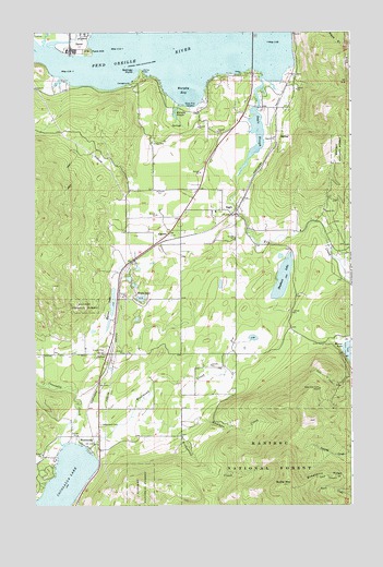
Sagle, ID USGS Topographic Map
Click on map above to begin viewing in our Map Viewer.

This topographic map contains these locations and features:
Feature Name Type Latitude Longitude GNIS ID View Map
AlgomaPopulated PlaceN48.1969°W116.5721°376529View Map
Bimetallic RidgeRidgeN48.1327°W116.5032°377640View Map
Bonner County EMS Station 3BuildingN48.2102°W116.5603°2642798View Map
Bridgeview CreekStreamN48.1485°W116.5877°378228View Map
Butler MountainSummitN48.1305°W116.5255°397507View Map
Cocolalla LakeLakeN48.1267°W116.6155°379482View Map
Cocolalla Lake Access AreaLocaleN48.1410°W116.6038°401237View Map
Cocolalla Post OfficePost OfficeN48.1430°W116.6008°2766807View Map
Dover Post OfficePost OfficeN48.2491°W116.6058°2766865View Map
DufortPopulated PlaceN48.1652°W116.5969°380922View Map
Fry CreekStreamN48.2119°W116.5449°382116View Map
Heath LakeLakeN48.1797°W116.5834°383038View Map
Hickman CreekStreamN48.1477°W116.5599°383135View Map
Hope and Faith ShaftMineN48.1557°W116.5135°383319View Map
LignitePopulated PlaceN48.2288°W116.5410°399103View Map
Mirror Lake AccessLocaleN48.1680°W116.5021°394229View Map
Mirror Lake Access AreaLocaleN48.1657°W116.5044°401604View Map
Murphy BayBayN48.2346°W116.5646°387407View Map
Murphy SloughStreamN48.2308°W116.5682°387412View Map
Osprey Nests ViewpointLocaleN48.2405°W116.5388°394227View Map
Reed HillSummitN48.1896°W116.5449°394219View Map
SaglePopulated PlaceN48.2024°W116.5477°389817View Map
Sagle Community HallLocaleN48.1938°W116.5391°394228View Map
Sagle Elementary SchoolSchoolN48.2027°W116.5538°401667View Map
Sagle Post OfficePost OfficeN48.2008°W116.5670°2767319View Map
Sagle SloughStreamN48.2383°W116.5346°389818View Map
Sandpoint Fish HatcheryLocaleN48.2299°W116.5641°401192View Map
Selkirk Fire Sagle StationBuildingN48.1949°W116.5780°2618944View Map
Shepherd LakeLakeN48.1849°W116.5275°390297View Map
Shepherd Lake Access AreaLocaleN48.1883°W116.5319°401678View Map
Springy PointCapeN48.2396°W116.5852°1802583View Map
Springy Point CampgroundLocaleN48.2363°W116.5874°394226View Map
Tank HillSummitN48.2449°W116.6038°398215View Map
WestmondPopulated PlaceN48.1399°W116.6035°398341View Map
Westmond CemeteryCemeteryN48.1461°W116.5993°393255View Map
Westmond CreekStreamN48.1396°W116.6052°393256View Map

Note: Coordinates in the location and feature list above are referenced to NAD83 datum.


Copyright (C) 2008-2024 Ryan Niemi / Sunset Dynamics ... All Rights Reserved