TopoQuest Logo
Do you find TopoQuest useful?
Help keep TopoQuest running and adding new maps/features by donating!
Bitcoin:  19c7KJd3qBynnjoSw5npx9KScwjBe4ifkT
Litecoin:  LXs6TkuXGGXo1vDsWCkWVdjQX94eUKd6ui
Home View Maps Find Maps Find Places Resources & Links


Sacheen Lake, Washington Topographic Map

USGS Map Title: Sacheen Lake, WA
USGS Map MRC: 48117B3
DRG (GeoTIFF) Download: o48117b3.tif


Neighboring USGS Topographic Map Quads:


  Winchester Peak, WA  
48117C4
 

  Cusick, WA  
48117C3
 

  Skookum Creek, WA  
48117C2
 

  Boyer Mountain, WA  
48117B4
 

  Sacheen Lake, WA  
48117B3
 

  Diamond Lake, WA  
48117B2
 

  Fan Lake, WA  
48117A4
 

  Elk, WA  
48117A3
 

  Camden, WA  
48117A2


Map MRC Location:

N49°
W118°
N49°
W117°
H8 H7 H6 H5 H4 H3 H2 H1
G8 G7 G6 G5 G4 G3 G2 G1
F8 F7 F6 F5 F4 F3 F2 F1
E8 E7 E6 E5 E4 E3 E2 E1
D8 D7 D6 D5 D4 D3 D2 D1
C8 C7 C6 C5 C4 C3 C2 C1
B8 B7 B6 B5 B4 B3 B2 B1
A8 A7 A6 A5 A4 A3 A2 A1
N48°
W118°
N48°
W117°

Sacheen Lake, WA USGS 1:24K Topographic Map Preview:
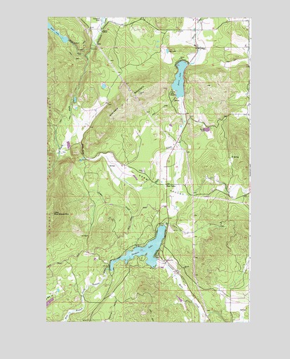
Sacheen Lake, WA USGS Topographic Map
Click on map above to begin viewing in our Map Viewer.

This topographic map contains these locations and features:
Feature Name Type Latitude Longitude GNIS ID View Map
Baker LakeReservoirN48.2040°W117.2770°1532918View Map
Baker Lake DamDamN48.2016°W117.2777°1532917View Map
Camp SpauldingLocaleN48.2193°W117.2969°1517312View Map
Cedar CreekStreamN48.1555°W117.3199°1517536View Map
Davis LakeReservoirN48.2242°W117.2938°1518506View Map
Davis Lake DamDamN48.2316°W117.2877°1532604View Map
Deer CreekStreamN48.2177°W117.2927°1518609View Map
Deer ValleyPopulated PlaceN48.1816°W117.3008°1518656View Map
Deer ValleyValleyN48.1957°W117.2919°1518658View Map
Homestead LakeReservoirN48.1344°W117.2934°1531979View Map
Homestead Lake DamDamN48.1332°W117.2927°1531978View Map
Law LakeLakeN48.2361°W117.3015°1521950View Map
Little Blue Grouse MountainSummitN48.1693°W117.3711°1522162View Map
Little Spokane River DamDamN48.1349°W117.3527°1532886View Map
Moon CreekStreamN48.1485°W117.3072°1523343View Map
North Fork Calispell CreekStreamN48.2338°W117.3499°1523745View Map
Power LakeReservoirN48.2437°W117.3703°1524612View Map
Power Lake DamDamN48.2399°W117.3627°1531952View Map
Rocky GorgeValleyN48.1927°W117.3516°1525170View Map
Sacheen LakeLakeN48.1545°W117.3141°1525323View Map
South Fork Calispell CreekStreamN48.2338°W117.3502°1526167View Map
South Pend Oreille Fire and Rescue Station 32 - Sacheen LakeBuildingN48.1765°W117.3022°2643701View Map

Note: Coordinates in the location and feature list above are referenced to NAD83 datum.


Copyright (C) 2008-2024 Ryan Niemi / Sunset Dynamics ... All Rights Reserved