TopoQuest Logo
Do you find TopoQuest useful?
Help keep TopoQuest running and adding new maps/features by donating!
Bitcoin:  19c7KJd3qBynnjoSw5npx9KScwjBe4ifkT
Litecoin:  LXs6TkuXGGXo1vDsWCkWVdjQX94eUKd6ui
Home View Maps Find Maps Find Places Resources & Links


Ruth Lake, California Topographic Map

USGS Map Title: Ruth Lake, CA
USGS Map MRC: 40123C4
DRG (GeoTIFF) Download: o40123c4.tif


Neighboring USGS Topographic Map Quads:


  Dinsmore, CA  
40123D5
 

  Sportshaven, CA  
40123D4
 

  Naufus Creek, CA  
40123D3
 

  Black Lassic, CA  
40123C5
 

  Ruth Lake, CA  
40123C4
 

  Forest Glen, CA  
40123C3
 

  Alderpoint, CA  
40123B5
 

  Zenia, CA  
40123B4
 

  Shannon Butte, CA  
40123B3


Map MRC Location:

N41°
W124°
N41°
W123°
H8 H7 H6 H5 H4 H3 H2 H1
G8 G7 G6 G5 G4 G3 G2 G1
F8 F7 F6 F5 F4 F3 F2 F1
E8 E7 E6 E5 E4 E3 E2 E1
D8 D7 D6 D5 D4 D3 D2 D1
C8 C7 C6 C5 C4 C3 C2 C1
B8 B7 B6 B5 B4 B3 B2 B1
A8 A7 A6 A5 A4 A3 A2 A1
N40°
W124°
N40°
W123°

Ruth Lake, CA USGS 1:24K Topographic Map Preview:
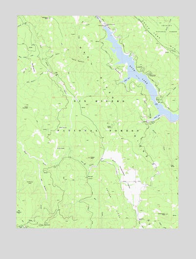
Ruth Lake, CA USGS Topographic Map
Click on map above to begin viewing in our Map Viewer.

This topographic map contains these locations and features:
Feature Name Type Latitude Longitude GNIS ID View Map
Allen SpringSpringN40.2870°W123.3824°218146View Map
Bailey Canyon CampgroundLocaleN40.3407°W123.4000°218523View Map
Bailey Canyon CampgroundLocaleN40.3404°W123.3998°276255View Map
Big MeadowFlatN40.2585°W123.4998°255069View Map
Big Meadow CreekStreamN40.2901°W123.4839°219216View Map
Black Lassic CreekStreamN40.3510°W123.4836°255070View Map
Boles OpeningFlatN40.3088°W123.4659°219602View Map
Coon GulchValleyN40.3493°W123.4792°221507View Map
Devils BackboneRidgeN40.3493°W123.4542°222282View Map
Dillon CoveBayN40.3376°W123.4159°222389View Map
Duncan RanchLocaleN40.2865°W123.4275°276256View Map
Fir Cove CampgroundLocaleN40.3429°W123.4045°276254View Map
Fir Cove CampgroundLocaleN40.3429°W123.4048°223514View Map
Gilman RanchLocaleN40.2810°W123.4222°276257View Map
Green MountainSummitN40.3221°W123.4936°224552View Map
Grizzly MountainSummitN40.2529°W123.4770°224644View Map
Hale CreekStreamN40.3738°W123.4384°224787View Map
Hetten CoveBayN40.3160°W123.3925°225219View Map
Hetten CreekStreamN40.3132°W123.3959°225220View Map
Hetten RidgeRidgeN40.2657°W123.4242°225221View Map
Hetten RockPillarN40.2918°W123.4442°225222View Map
Hettenshaw PeakSummitN40.2588°W123.3861°225223View Map
Hettenshaw SchoolSchoolN40.2724°W123.4186°276259View Map
Hettenshaw ValleyValleyN40.2893°W123.4353°225224View Map
Mad River Ranger Station (historical)LocaleN40.3201°W123.3889°1683009View Map
Mad River RockPillarN40.3735°W123.4770°227900View Map
Murphy GladesFlatN40.2963°W123.4675°229351View Map
Old Wilburn RanchLocaleN40.2556°W123.4068°2778485View Map
Old Willburn RanchLocaleN40.2554°W123.4070°229989View Map
Old Womans HomeBuildingN40.2754°W123.4909°229992View Map
Pickett CreekStreamN40.3238°W123.3903°230617View Map
Rainey GladesFlatN40.3429°W123.4231°231191View Map
Red Lassic CreekStreamN40.3435°W123.4753°231341View Map
Refuge ValleyBasinN40.2796°W123.4439°231479View Map
Robert W Matthews DamDamN40.3690°W123.4323°231676View Map
Ruth Guard Station (historical)LocaleN40.3260°W123.3895°1665695View Map
Ruth LakeReservoirN40.3348°W123.4005°232057View Map
Rutled OpeningFlatN40.3443°W123.4892°232059View Map
Shanty CreekStreamN40.3701°W123.4953°234679View Map
Stapp RanchLocaleN40.2776°W123.4222°276258View Map
Ueland PlacePopulated PlaceN40.3129°W123.3967°1660070View Map
Waggit SpringSpringN40.3096°W123.4279°237148View Map
Watts LakeLakeN40.2504°W123.4964°237360View Map
Watts Lake Recreation SiteLocaleN40.2504°W123.4970°1655288View Map
West Fork Van Duzen RiverStreamN40.2996°W123.4603°255224View Map

Note: Coordinates in the location and feature list above are referenced to NAD83 datum.


Copyright (C) 2008-2024 Ryan Niemi / Sunset Dynamics ... All Rights Reserved