TopoQuest Logo
Do you find TopoQuest useful?
Help keep TopoQuest running and adding new maps/features by donating!
Bitcoin:  19c7KJd3qBynnjoSw5npx9KScwjBe4ifkT
Litecoin:  LXs6TkuXGGXo1vDsWCkWVdjQX94eUKd6ui
Home View Maps Find Maps Find Places Resources & Links


Royal Gorge, California Topographic Map

USGS Map Title: Royal Gorge, CA
USGS Map MRC: 39120B4
DRG (GeoTIFF) Download: o39120b4.tif


Neighboring USGS Topographic Map Quads:


  Cisco Grove, CA  
39120C5
 

  Soda Springs, CA  
39120C4
 

  Norden, CA  
39120C3
 

  Duncan Peak, CA  
39120B5
 

  Royal Gorge, CA  
39120B4
 

  Granite Chief, CA  
39120B3
 

  Greek Store, CA  
39120A5
 

  Bunker Hill, CA  
39120A4
 

  Wentworth Springs, CA  
39120A3


Map MRC Location:

N40°
W121°
N40°
W120°
H8 H7 H6 H5 H4 H3 H2 H1
G8 G7 G6 G5 G4 G3 G2 G1
F8 F7 F6 F5 F4 F3 F2 F1
E8 E7 E6 E5 E4 E3 E2 E1
D8 D7 D6 D5 D4 D3 D2 D1
C8 C7 C6 C5 C4 C3 C2 C1
B8 B7 B6 B5 B4 B3 B2 B1
A8 A7 A6 A5 A4 A3 A2 A1
N39°
W121°
N39°
W120°

Royal Gorge, CA USGS 1:24K Topographic Map Preview:
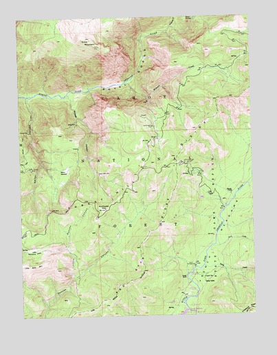
Royal Gorge, CA USGS Topographic Map
Click on map above to begin viewing in our Map Viewer.

This topographic map contains these locations and features:
Feature Name Type Latitude Longitude GNIS ID View Map
Ahart CampgroundLocaleN39.1457°W120.4074°218022View Map
Black Bear CampgroundLocaleN39.1332°W120.4099°1701143View Map
Chalk BluffCliffN39.1410°W120.4146°220881View Map
Coyote Group CampgroundLocaleN39.1355°W120.4116°1701148View Map
Coyote SpringSpringN39.1415°W120.4017°221771View Map
Deadman FlatFlatN39.1874°W120.3755°1701151View Map
Dolly CreekStreamN39.1455°W120.4024°222476View Map
French MeadowsFlatN39.1593°W120.3938°233907View Map
Gates CabinLocaleN39.1391°W120.4021°224096View Map
Gates Group CampgroundLocaleN39.1413°W120.4102°1701162View Map
Handy CampLocaleN39.1757°W120.3874°224867View Map
Heath SpringSpringN39.2496°W120.4060°225103View Map
Lewis CampgroundLocaleN39.1385°W120.4088°227039View Map
Little Duncan CanyonValleyN39.1416°W120.4710°227253View Map
Little Duncan CreekStreamN39.1416°W120.4716°1701169View Map
Little Robinsons ValleyValleyN39.1532°W120.4749°254922View Map
Lost Emigrant MineMineN39.2041°W120.4285°227702View Map
Oak FlatFlatN39.1982°W120.4985°229843View Map
Palisade CreekStreamN39.2438°W120.4199°230253View Map
Placer Queen MineMineN39.1843°W120.4577°230791View Map
Rice CreekStreamN39.1543°W120.3966°231527View Map
Royal GorgeAreaN39.2280°W120.4360°1701183View Map
Royal Gorge RiverStreamN39.2196°W120.4627°231990View Map
Sailor CanyonValleyN39.2168°W120.4960°234603View Map
Sailor Canyon MineMineN39.1866°W120.4944°232122View Map
Sailor Flat TrailTrailN39.2071°W120.4955°232123View Map
Sailor MeadowFlatN39.1866°W120.4760°232125View Map
Sailore Flat TrailTrailN39.2010°W120.4971°1655214View Map
Snow MountainSummitN39.2413°W120.4638°234777View Map
Sunflower HillSummitN39.1702°W120.4546°235781View Map
Tevis Cup TrailTrailN39.2080°W120.3977°1655216View Map
Trinidad MineMineN39.2018°W120.4963°236545View Map
Wabena CreekStreamN39.2227°W120.4402°237141View Map
Wabena TrailTrailN39.2166°W120.4321°276053View Map
Walker MineMineN39.2052°W120.4696°237179View Map
Wildcat CanyonValleyN39.2182°W120.4749°237777View Map
X-Ray MineMineN39.1860°W120.4983°238216View Map

Note: Coordinates in the location and feature list above are referenced to NAD83 datum.


Copyright (C) 2008-2024 Ryan Niemi / Sunset Dynamics ... All Rights Reserved