TopoQuest Logo
Do you find TopoQuest useful?
Help keep TopoQuest running and adding new maps/features by donating!
Bitcoin:  19c7KJd3qBynnjoSw5npx9KScwjBe4ifkT
Litecoin:  LXs6TkuXGGXo1vDsWCkWVdjQX94eUKd6ui
Home View Maps Find Maps Find Places Resources & Links


Rosita, Colorado Topographic Map

USGS Map Title: Rosita, CO
USGS Map MRC: 38105A3
DRG (GeoTIFF) Download: o38105a3.tif


Neighboring USGS Topographic Map Quads:


  Westcliffe, CO  
38105B4
 

  Mount Tyndall, CO  
38105B3
 

  Hardscrabble Mountain, CO  
38105B2
 

  Aldrich Gulch, CO  
38105A4
 

  Rosita, CO  
38105A3
 

  Deer Peak, CO  
38105A2
 

  Beck Mountain, CO  
37105H4
 

  Devils Gulch, CO  
37105H3
 

  Bear Creek, CO  
37105H2


Map MRC Location:

N39°
W106°
N39°
W105°
H8 H7 H6 H5 H4 H3 H2 H1
G8 G7 G6 G5 G4 G3 G2 G1
F8 F7 F6 F5 F4 F3 F2 F1
E8 E7 E6 E5 E4 E3 E2 E1
D8 D7 D6 D5 D4 D3 D2 D1
C8 C7 C6 C5 C4 C3 C2 C1
B8 B7 B6 B5 B4 B3 B2 B1
A8 A7 A6 A5 A4 A3 A2 A1
N38°
W106°
N38°
W105°

Rosita, CO USGS 1:24K Topographic Map Preview:
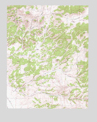
Rosita, CO USGS Topographic Map
Click on map above to begin viewing in our Map Viewer.

This topographic map contains these locations and features:
Feature Name Type Latitude Longitude GNIS ID View Map
Antelope ButteSummitN38.0583°W105.2986°192324View Map
Antelope SchoolSchoolN38.0461°W105.3044°192323View Map
Antrim and GW LodeMineN38.1203°W105.3314°1734019View Map
Arkansas MountainSummitN38.1192°W105.2639°203580View Map
Bald MountainSummitN38.0914°W105.3256°196655View Map
Bassier MineMineN38.0300°W105.3322°1734020View Map
Breece CreekStreamN38.0375°W105.2697°192329View Map
Concord HillSummitN38.1097°W105.3572°192306View Map
Custer CountyCivilN38.1087°W105.3675°198129View Map
Democrat HillSummitN38.1067°W105.3611°192307View Map
Democrat MineMineN38.1022°W105.3656°1734021View Map
Democrat RidgeRidgeN38.1125°W105.3600°192304View Map
DeWeese PlateauPlainN38.0125°W105.2631°196617View Map
Dutch FlatFlatN38.1181°W105.3250°192317View Map
Fair View LodeMineN38.0469°W105.3297°1734017View Map
Game RidgeRidgeN38.1042°W105.3242°192318View Map
Goodhope GulchValleyN38.1037°W105.3619°192303View Map
Hobby RanchLocaleN38.1133°W105.2833°192320View Map
Humboldt MineMineN38.0978°W105.3369°1734022View Map
Iron HillSummitN38.1192°W105.3711°192301View Map
Jones GulchValleyN38.0454°W105.3051°192325View Map
Junkins ParkBasinN38.1083°W105.2700°203581View Map
Junkins Park SchoolSchoolN38.1100°W105.2597°192321View Map
Knickerbocker HillSummitN38.1214°W105.3747°192300View Map
Lapin CreekStreamN38.0217°W105.3619°192326View Map
Little Antelope CreekStreamN38.0464°W105.2533°192344View Map
Mount FairviewSummitN38.1150°W105.3661°192302View Map
Mount RobinsonSummitN38.1139°W105.3453°192308View Map
Mount Robinson MineMineN38.1203°W105.3428°1734023View Map
Paris HillSummitN38.1119°W105.3681°192305View Map
Pennsylvania HillSummitN38.0925°W105.3436°192312View Map
Piltz CreekStreamN38.0469°W105.2972°192327View Map
Plymouth HIllSummitN38.0981°W105.3239°196648View Map
Pocahontas HillSummitN38.1058°W105.3331°192316View Map
Poverty GulchValleyN38.0911°W105.3486°192315View Map
Pringle HillSummitN38.1050°W105.3447°192309View Map
Robinson PlateauAreaN38.1194°W105.3394°192314View Map
RositaPopulated PlaceN38.0972°W105.3361°192319View Map
Rosita CemeteryCemeteryN38.0911°W105.3525°192311View Map
Rosita GulchValleyN38.0730°W105.3526°192310View Map
Rosita HillsRangeN38.1214°W105.3567°192180View Map
Rosita MineMineN38.1194°W105.3661°1734016View Map
Rosita PitMineN38.0031°W105.3650°1734024View Map
Smith RanchLocaleN38.0714°W105.3300°192322View Map
Sunshine Valley LodeMineN38.0889°W105.2936°1734018View Map
Wakefield HillSummitN38.0900°W105.3353°192313View Map
Westcliffe DivisionCivilN38.1087°W105.3675°1935594View Map
Wet Mountain Fire Protection District Station 5 RositaBuildingN38.0993°W105.3322°2695586View Map
Wet MountainsRangeN38.0933°W105.2603°204777View Map

Note: Coordinates in the location and feature list above are referenced to NAD83 datum.


Copyright (C) 2008-2024 Ryan Niemi / Sunset Dynamics ... All Rights Reserved