TopoQuest Logo
Do you find TopoQuest useful?
Help keep TopoQuest running and adding new maps/features by donating!
Bitcoin:  19c7KJd3qBynnjoSw5npx9KScwjBe4ifkT
Litecoin:  LXs6TkuXGGXo1vDsWCkWVdjQX94eUKd6ui
Home View Maps Find Maps Find Places Resources & Links


Rockport, West Virginia Topographic Map

USGS Map Title: Rockport, WV
USGS Map MRC: 39081A5
DRG (GeoTIFF) Download: o39081a5.tif


Neighboring USGS Topographic Map Quads:


  Lubeck, WV  
39081B6
 

  South Parkersburg, WV  
39081B5
 

  Kanawha, WV  
39081B4
 

  Pond Creek, WV  
39081A6
 

  Rockport, WV  
39081A5
 

  Elizabeth, WV  
39081A4
 

  Sandyville, WV  
38081H6
 

  Liverpool, WV  
38081H5
 

  Reedy, WV  
38081H4


Map MRC Location:

N40°
W82°
N40°
W81°
H8 H7 H6 H5 H4 H3 H2 H1
G8 G7 G6 G5 G4 G3 G2 G1
F8 F7 F6 F5 F4 F3 F2 F1
E8 E7 E6 E5 E4 E3 E2 E1
D8 D7 D6 D5 D4 D3 D2 D1
C8 C7 C6 C5 C4 C3 C2 C1
B8 B7 B6 B5 B4 B3 B2 B1
A8 A7 A6 A5 A4 A3 A2 A1
N39°
W82°
N39°
W81°

Rockport, WV USGS 1:24K Topographic Map Preview:
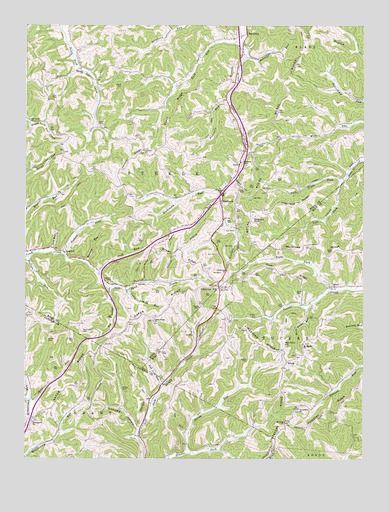
Rockport, WV USGS Topographic Map
Click on map above to begin viewing in our Map Viewer.

This topographic map contains these locations and features:
Feature Name Type Latitude Longitude GNIS ID View Map
Amos CemeteryCemeteryN39.0965°W81.5985°1534925View Map
Anderson CemeteryCemeteryN39.0365°W81.6037°1534940View Map
Archer CemeteryCemeteryN39.0201°W81.5890°1534998View Map
Ash Lick RunStreamN39.0212°W81.5737°1535050View Map
Beech Grove School (historical)SchoolN39.0115°W81.6218°1559893View Map
Beechgrove ChurchChurchN39.0106°W81.6218°1535562View Map
Bethel CemeteryCemeteryN39.0501°W81.5118°1852304View Map
Bethel ChurchChurchN39.0501°W81.5118°1535705View Map
Big Indian RunStreamN39.0492°W81.5935°1535866View Map
Bogal RidgeRidgeN39.1070°W81.5298°1536186View Map
Bogal School (historical)SchoolN39.1209°W81.5204°1560351View Map
Brown RidgeRidgeN39.0604°W81.5682°1536413View Map
Buck RunStreamN39.0531°W81.5985°1536567View Map
Buck RunStreamN39.1184°W81.5454°1536569View Map
Buck Run School (historical)SchoolN39.1076°W81.5707°1560355View Map
Buffalo RunStreamN39.0581°W81.6240°1536650View Map
Burns RunStreamN39.0748°W81.5526°1536757View Map
Centennial School (historical)SchoolN39.0873°W81.5793°1560357View Map
Central Church of ChristChurchN39.0890°W81.5815°1537162View Map
Central Church of Christ CemeteryCemeteryN39.0884°W81.5815°1986754View Map
Central RidgeRidgeN39.0867°W81.5862°1537167View Map
Courtney RidgeRidgeN39.0148°W81.5126°1537716View Map
Deem CemeteryCemeteryN39.0601°W81.5115°1538101View Map
Dutch RidgeRidgeN39.1006°W81.5693°1538468View Map
Fivemile RunStreamN39.1029°W81.5501°1539031View Map
Gaites CemeteryCemeteryN39.0284°W81.5429°1539308View Map
Gant CemeteryCemeteryN39.0476°W81.5226°1539326View Map
Gates RidgeRidgeN39.0351°W81.5918°1539357View Map
Gates Ridge ChurchChurchN39.0395°W81.5776°1539358View Map
Gates Ridge Evangelical United Brethren Church CemeteryCemeteryN39.0395°W81.5776°1986765View Map
Gates Ridge School (historical)SchoolN39.0409°W81.5793°1560397View Map
Joes RunStreamN39.0595°W81.6154°1540939View Map
Joshus ForkStreamN39.0587°W81.6110°1541031View Map
Kiser RidgeRidgeN39.0548°W81.5326°1541248View Map
Lee Creek ChurchChurchN39.0976°W81.6235°1541605View Map
Left Fork Slate CreekStreamN39.0798°W81.5082°1541724View Map
Limestone CemeteryCemeteryN39.0551°W81.5504°1986777View Map
Limestone ChurchChurchN39.0542°W81.5507°1541974View Map
Limestone HillLocaleN39.0495°W81.5535°1541976View Map
Limestone RidgeRidgeN39.0059°W81.5323°1541977View Map
Little Indian RunStreamN39.0484°W81.5873°1542127View Map
Lott CemeteryCemeteryN39.1040°W81.6157°1542475View Map
LowdellPopulated PlaceN39.0598°W81.6112°1555004View Map
Lowdell CemeteryCemeteryN39.0515°W81.5932°1542514View Map
Mail Point HillSummitN39.0326°W81.5293°1542699View Map
Mail Point RunStreamN39.0434°W81.5210°1542700View Map
Mannon RunStreamN39.0565°W81.6029°1542723View Map
McKinley (historical)Populated PlaceN39.0892°W81.5818°1560438View Map
Mentor School (historical)SchoolN39.0462°W81.6087°1560441View Map
Mount Hope School (historical)SchoolN39.0784°W81.5890°1560447View Map
Mount Hope United Methodist ChurchChurchN39.0106°W81.5287°1543662View Map
Mount Moriah CemeteryCemeteryN39.0330°W81.5218°2586345View Map
Mount Moriah ChurchChurchN39.0331°W81.5223°1543679View Map
Naylor CemeteryCemeteryN39.1076°W81.5896°1544062View Map
New Era School (historical)SchoolN39.0298°W81.6021°1560014View Map
Nicholas HollowValleyN39.0084°W81.5832°1544167View Map
Pond Creek School (historical)SchoolN39.0512°W81.5679°1560482View Map
Prosperity CemeteryCemeteryN39.0142°W81.5240°1678776View Map
Prosperity ChurchChurchN39.0145°W81.5240°1545292View Map
Queen HollowValleyN39.0801°W81.5476°1545335View Map
Ratcliff RunStreamN39.1156°W81.5437°1545418View Map
Right Fork Slate CreekStreamN39.0798°W81.5079°1545704View Map
Right Fork Tucker CreekStreamN39.0487°W81.5121°1545718View Map
Rising Sun School (historical)SchoolN39.0809°W81.5162°1560491View Map
Rockcamp RunStreamN39.0765°W81.5529°1545948View Map
RockportPopulated PlaceN39.0742°W81.5532°1555508View Map
Rockport School (historical)SchoolN39.0854°W81.5457°1545997View Map
Sandy CemeteryCemeteryN39.0434°W81.5607°1546402View Map
Sandy RunStreamN39.0015°W81.5654°1546414View Map
Sarepta ChurchChurchN39.1123°W81.6048°1546435View Map
SaulsburyPopulated PlaceN39.1226°W81.5435°1555575View Map
Shaffer CemeteryCemeteryN39.0342°W81.6165°1546604View Map
Simpson United Methodist Church CemeteryCemeteryN39.0343°W81.6167°2726941View Map
Skull RunStreamN39.0154°W81.6229°1546874View Map
Smith CemeteryCemeteryN39.1165°W81.6157°1891024View Map
Steele DistrictCivilN39.0893°W81.5914°1928373View Map
Stephens Fork School (historical)SchoolN39.1215°W81.5735°1560513View Map
Stephens KnobSummitN39.0681°W81.5412°1547386View Map
Stephens RidgeRidgeN39.0740°W81.5237°1547388View Map
Summerville School (historical)SchoolN39.0037°W81.5562°1560070View Map
Valley Belle School (historical)SchoolN39.1042°W81.5510°1560525View Map
Wigal School (historical)SchoolN39.1234°W81.6096°1560546View Map
WindyPopulated PlaceN39.0281°W81.5282°1556005View Map
Wolf Run School (historical)SchoolN39.0979°W81.5110°1560556View Map

Note: Coordinates in the location and feature list above are referenced to NAD83 datum.


Copyright (C) 2008-2024 Ryan Niemi / Sunset Dynamics ... All Rights Reserved