TopoQuest Logo
Do you find TopoQuest useful?
Help keep TopoQuest running and adding new maps/features by donating!
Bitcoin:  19c7KJd3qBynnjoSw5npx9KScwjBe4ifkT
Litecoin:  LXs6TkuXGGXo1vDsWCkWVdjQX94eUKd6ui
Home View Maps Find Maps Find Places Resources & Links


Rockholds, Kentucky Topographic Map

USGS Map Title: Rockholds, KY
USGS Map MRC: 36084G1
DRG (GeoTIFF) Download: o36084g1.tif


Neighboring USGS Topographic Map Quads:


  Vox, KY  
36084H2
 

  Corbin, KY  
36084H1
 

  Heidrick, KY  
36083H8
 

  Wofford, KY  
36084G2
 

  Rockholds, KY  
36084G1
 

  Barbourville, KY  
36083G8
 

  Williamsburg, KY  
36084F2
 

  Saxton, KY  
36084F1
 

  Frakes, KY  
36083F8


Map MRC Location:

N37°
W85°
N37°
W84°
H8 H7 H6 H5 H4 H3 H2 H1
G8 G7 G6 G5 G4 G3 G2 G1
F8 F7 F6 F5 F4 F3 F2 F1
E8 E7 E6 E5 E4 E3 E2 E1
D8 D7 D6 D5 D4 D3 D2 D1
C8 C7 C6 C5 C4 C3 C2 C1
B8 B7 B6 B5 B4 B3 B2 B1
A8 A7 A6 A5 A4 A3 A2 A1
N36°
W85°
N36°
W84°

Rockholds, KY USGS 1:24K Topographic Map Preview:
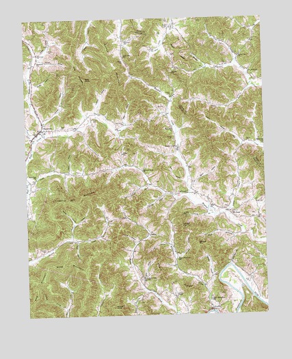
Rockholds, KY USGS Topographic Map
Click on map above to begin viewing in our Map Viewer.

This topographic map contains these locations and features:
Feature Name Type Latitude Longitude GNIS ID View Map
Bald KnobSummitN36.8495°W84.0930°486264View Map
Bays CemeteryCemeteryN36.8315°W84.0741°486495View Map
Bays HollowValleyN36.8303°W84.0721°486499View Map
Bear BranchStreamN36.7840°W84.0124°486517View Map
Berry HollowValleyN36.7627°W84.0650°486914View Map
Berry SchoolSchoolN36.7962°W84.0277°486916View Map
Bisco Railroad Station (historical)LocaleN36.8425°W84.1216°2710172View Map
Brown CemeteryCemeteryN36.7965°W84.0019°487989View Map
Brummett ChurchChurchN36.8601°W84.1174°488057View Map
Brummett Railroad Station (historical)LocaleN36.8578°W84.1199°2710059View Map
Brummett SchoolSchoolN36.8573°W84.1180°488058View Map
Bunch MountainSummitN36.8573°W84.0805°488385View Map
Caney BranchStreamN36.7926°W84.0277°488812View Map
Carr CreekStreamN36.8240°W84.1191°511228View Map
Carter CemeteryCemeteryN36.8598°W84.0477°489001View Map
Cedar GapGapN36.8573°W84.0730°489191View Map
Cedar Gap SchoolSchoolN36.8590°W84.0727°489192View Map
Chestnut Oak MountainSummitN36.8004°W84.0955°489459View Map
Coffee SchoolSchoolN36.8181°W84.0744°489773View Map
Colonel HollowValleyN36.8323°W84.1149°489878View Map
Cotton CreekStreamN36.7926°W84.0208°490143View Map
Crig ChapelChurchN36.8018°W84.0410°490344View Map
Darway Railroad Station (historical)LocaleN36.8066°W84.1231°2710072View Map
Davis CemeteryCemeteryN36.8292°W84.1058°490645View Map
Dead Man HollowValleyN36.7708°W84.0181°490720View Map
Dowis ChapelChurchN36.8737°W84.0488°491074View Map
Dowis SchoolSchoolN36.8712°W84.0483°491075View Map
Eatin ForkStreamN36.8454°W84.0052°491528View Map
Egnar HollowValleyN36.8051°W84.0372°491587View Map
Flat Creek ChurchChurchN36.8218°W84.0002°492185View Map
Hart CemeteryCemeteryN36.8373°W84.0519°493836View Map
Hart SchoolSchoolN36.8284°W84.0480°493839View Map
Hill ChapelLocaleN36.7926°W84.0174°494248View Map
Hill HollowValleyN36.7744°W84.0466°494252View Map
Hill HollowValleyN36.7794°W84.0499°494253View Map
Hubbs HollowValleyN36.8221°W84.0116°494712View Map
Imperial HollowValleyN36.8351°W84.0873°494896View Map
Indian Gap ChurchChurchN36.8587°W84.0124°494947View Map
Jacks ForkStreamN36.8037°W84.1233°495092View Map
Jacks Fork SchoolSchoolN36.8084°W84.1197°495093View Map
John Sharpe Historical MarkerParkN36.8099°W84.0953°2745308View Map
Johnson HollowValleyN36.8010°W84.0526°495410View Map
Jones HollowValleyN36.7801°W84.0683°495503View Map
Jonny HollowValleyN36.8585°W84.1168°495521View Map
King CemeteryCemeteryN36.8329°W84.0888°495738View Map
King MountainSummitN36.8504°W84.0958°495746View Map
Lawson ChapelChurchN36.7579°W84.0480°496089View Map
Lawson High TopSummitN36.7873°W84.0438°496090View Map
Lee CemeteryCemeteryN36.8617°W84.0580°496156View Map
Logan HollowValleyN36.8109°W84.1019°496984View Map
LoudenPopulated PlaceN36.7518°W84.0258°508509View Map
Louden Coal Camp (historical)Populated PlaceN36.7506°W84.0288°2710201View Map
Lower Whetstone SchoolSchoolN36.7559°W84.0288°497311View Map
Mackey CemeteryCemeteryN36.8234°W84.0091°497427View Map
Maple Creek SchoolSchoolN36.7654°W84.0627°497503View Map
Maple RidgeRidgeN36.7645°W84.0510°497516View Map
McFarland CemeteryCemeteryN36.8654°W84.0721°497848View Map
McNeil CemeteryCemeteryN36.8620°W84.1119°497936View Map
McNeil HollowValleyN36.8594°W84.1168°513882View Map
Meadow Creek ChurchChurchN36.8206°W84.0455°497984View Map
Meadow Grove ChurchChurchN36.8109°W84.0635°497990View Map
Melt HollowValleyN36.8065°W84.0422°498051View Map
Morgan HollowValleyN36.8480°W84.1203°498594View Map
Mosley BranchStreamN36.8548°W84.0144°498662View Map
PerkinsPopulated PlaceN36.7840°W84.0608°508802View Map
Perkins CemeteryCemeteryN36.7781°W84.1152°500409View Map
Phoebe ForkStreamN36.8048°W84.0605°500550View Map
Rainey HollowValleyN36.7889°W84.1001°501534View Map
RockholdsPopulated PlaceN36.8287°W84.1163°502166View Map
Rockholds Census Designated PlaceCensusN36.8308°W84.1131°2629672View Map
Rockholds Fire DepartmentBuildingN36.8271°W84.1156°2636825View Map
Round KnobSummitN36.7534°W84.0794°502403View Map
Sawyer HollowValleyN36.7658°W84.0285°503016View Map
Sawyer MountainSummitN36.7793°W84.0355°503017View Map
Short RidgeRidgeN36.8615°W84.0438°503456View Map
Simp HollowValleyN36.7826°W84.1019°503529View Map
Sims HollowValleyN36.7812°W84.0983°503549View Map
Smith CemeteryCemeteryN36.7631°W84.0094°503746View Map
Stanfield CemeteryCemeteryN36.8248°W84.0477°504252View Map
Stoles ForkStreamN36.8252°W84.1165°2504694View Map
Tar Kiln GapGapN36.7929°W84.0441°504957View Map
Turkey CreekStreamN36.7534°W84.1047°505587View Map
Upper Whetstone SchoolSchoolN36.7734°W84.0466°505919View Map
Walters CemeteryCemeteryN36.8426°W84.0483°506195View Map
Watts Creek Jellico Coal Company (historical)Populated PlaceN36.7944°W84.1248°2710257View Map
Wells SchoolSchoolN36.8518°W84.0055°506385View Map
Whetstone CreekStreamN36.7518°W84.0283°506545View Map
Whitley GapGapN36.8523°W84.0474°506688View Map
Wood MountainSummitN36.7737°W84.1041°507082View Map

Note: Coordinates in the location and feature list above are referenced to NAD83 datum.


Copyright (C) 2008-2024 Ryan Niemi / Sunset Dynamics ... All Rights Reserved