TopoQuest Logo
Do you find TopoQuest useful?
Help keep TopoQuest running and adding new maps/features by donating!
Bitcoin:  19c7KJd3qBynnjoSw5npx9KScwjBe4ifkT
Litecoin:  LXs6TkuXGGXo1vDsWCkWVdjQX94eUKd6ui
Home View Maps Find Maps Find Places Resources & Links


Robbinsville, North Carolina Topographic Map

USGS Map Title: Robbinsville, NC
USGS Map MRC: 35083C7
DRG (GeoTIFF) Download: o35083c7.tif


Neighboring USGS Topographic Map Quads:


  Tapoco, NC  
35083D8
 

  Fontana Dam, NC  
35083D7
 

  Tuskeegee, NC  
35083D6
 

  Santeetlah Creek, NC  
35083C8
 

  Robbinsville, NC  
35083C7
 

  Hewitt, NC  
35083C6
 

  Marble, NC  
35083B8
 

  Andrews, NC  
35083B7
 

  Topton, NC  
35083B6


Map MRC Location:

N36°
W84°
N36°
W83°
H8 H7 H6 H5 H4 H3 H2 H1
G8 G7 G6 G5 G4 G3 G2 G1
F8 F7 F6 F5 F4 F3 F2 F1
E8 E7 E6 E5 E4 E3 E2 E1
D8 D7 D6 D5 D4 D3 D2 D1
C8 C7 C6 C5 C4 C3 C2 C1
B8 B7 B6 B5 B4 B3 B2 B1
A8 A7 A6 A5 A4 A3 A2 A1
N35°
W84°
N35°
W83°

Robbinsville, NC USGS 1:24K Topographic Map Preview:
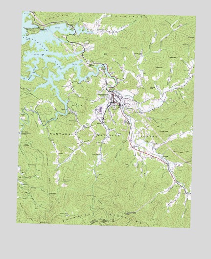
Robbinsville, NC USGS Topographic Map
Click on map above to begin viewing in our Map Viewer.

This topographic map contains these locations and features:
Feature Name Type Latitude Longitude GNIS ID View Map
17 Land TractAreaN35.3131°W83.8377°1018029View Map
373 Land TractAreaN35.3193°W83.8668°1018032View Map
477 Land TractAreaN35.3256°W83.8730°1018072View Map
588 Land TractAreaN35.2812°W83.8605°1018027View Map
589 Land TractAreaN35.2893°W83.8593°1018028View Map
91 Land TractAreaN35.3212°W83.8305°1018031View Map
93 Land TractAreaN35.3212°W83.8368°1018030View Map
Anderson CreekStreamN35.2776°W83.7610°1008726View Map
Atoah ChurchChurchN35.3081°W83.8271°1008808View Map
Atoah CreekStreamN35.3159°W83.8199°1008809View Map
Atoah GapGapN35.2673°W83.8513°1008810View Map
Auntney BranchStreamN35.2715°W83.7507°1018875View Map
Barker BranchStreamN35.3162°W83.8477°1008921View Map
Barker Road GapGapN35.2506°W83.8499°1008922View Map
Beech CreekStreamN35.3406°W83.7507°1009127View Map
Bert CreekStreamN35.2881°W83.7674°1009201View Map
Brooks GapGapN35.3651°W83.8621°1009638View Map
Buffalo ChurchChurchN35.3173°W83.8396°1009791View Map
Burgan CreekStreamN35.2723°W83.8213°1009818View Map
Campbell CreekStreamN35.2709°W83.7527°1009984View Map
Carpenter BranchStreamN35.2865°W83.7846°1010043View Map
Ceoah Paint CampgroundLocaleN35.3704°W83.8718°1018196View Map
Cheoah ChurchChurchN35.3193°W83.7982°1010191View Map
Cheoah Ranger District OfficeBuildingN35.3340°W83.8277°1018173View Map
Cherokee Police DepartmentBuildingN35.3034°W83.8745°2769641View Map
Cooloska BranchStreamN35.3226°W83.8399°1010460View Map
Cooper KnobSummitN35.3068°W83.7738°1019775View Map
Cornsilk BranchStreamN35.3026°W83.8738°1010489View Map
Davis BranchStreamN35.3384°W83.7552°1010678View Map
Deep GapGapN35.3748°W83.7866°1010754View Map
Deyton CampLocaleN35.3429°W83.8171°1010799View Map
Dobson HillSummitN35.3129°W83.8713°1019988View Map
Eagle KnobSummitN35.3445°W83.7782°1020067View Map
East Buffalo ChurchChurchN35.3645°W83.8207°1010973View Map
East Buffalo CreekStreamN35.3634°W83.8238°1010974View Map
Eller CoveValleyN35.2609°W83.8610°1011064View Map
Eller Mill CreekStreamN35.2670°W83.8657°1011066View Map
Fox Squirrel BranchStreamN35.2720°W83.8724°1011364View Map
Franks CreekStreamN35.2959°W83.7768°1011381View Map
Graham CountyCivilN35.3502°W83.8336°1008555View Map
Graham County Emergency Medical ServicesBuildingN35.3250°W83.8094°2720625View Map
Graham County Emergency Medical ServicesBuildingN35.3207°W83.7968°2720445View Map
Graham County Rescue SquadBuildingN35.3249°W83.8096°2720624View Map
Graham County Sheriff's OfficeBuildingN35.3256°W83.8027°2769789View Map
Graham County Volunteer Fire Department Fort Hill StationBuildingN35.3207°W83.7968°2639290View Map
Graham County Volunteer Fire Department Santopia StationBuildingN35.3498°W83.8309°2639289View Map
Green CreekStreamN35.3656°W83.7666°1011696View Map
Green GapGapN35.3620°W83.7502°1011697View Map
Ground Squirrel BranchStreamN35.3526°W83.8302°1011756View Map
Hares CreekStreamN35.2756°W83.7555°1011853View Map
Harwood BranchStreamN35.3315°W83.7666°1011899View Map
Henry GapGapN35.3554°W83.8038°1011972View Map
Hickory GapGapN35.2848°W83.8674°1012008View Map
Highland GapGapN35.3445°W83.8268°1012060View Map
Holloway BranchStreamN35.3312°W83.7693°1012136View Map
Holloway CemeteryCemeteryN35.3315°W83.7596°1012137View Map
Holly Cove BranchStreamN35.2915°W83.7907°1012140View Map
Hooper BranchStreamN35.3101°W83.8546°1012159View Map
Horse Range RidgeRidgeN35.2573°W83.8699°1012199View Map
Hunting Boy BranchStreamN35.2831°W83.8741°1012287View Map
I U GapGapN35.2915°W83.8471°1012323View Map
Jake BranchStreamN35.2940°W83.8341°1012420View Map
Joanna Bald Fire TowerTowerN35.2576°W83.7952°1018198View Map
John Teeseteska 367,404,405 Land TractAreaN35.2770°W83.8738°1018071View Map
Lake SanteetlahPopulated PlaceN35.3562°W83.8382°1022499View Map
Leonard Phillips DamDamN35.3134°W83.7999°1017157View Map
Leonard Phillips LakeReservoirN35.3134°W83.7999°1017158View Map
Lone Oak ChurchChurchN35.3612°W83.8443°1013087View Map
Long BranchStreamN35.2979°W83.8732°1013104View Map
Long BranchStreamN35.3187°W83.7888°1013108View Map
Long CreekStreamN35.3293°W83.8113°1013150View Map
Long Creek ChurchChurchN35.2918°W83.8155°1013152View Map
Long Hungry BranchStreamN35.3281°W83.8646°1013158View Map
Massey BranchStreamN35.3359°W83.8357°1013361View Map
Massey CemeteryCemeteryN35.3315°W83.8405°1013362View Map
Mauney BranchStreamN35.3262°W83.8124°1013376View Map
Mauney GapGapN35.3240°W83.8271°1013379View Map
Mill CreekStreamN35.2979°W83.7891°1013554View Map
Millpon CreekStreamN35.2840°W83.7666°1013595View Map
MilltownPopulated PlaceN35.3101°W83.8155°1021479View Map
Moose BranchStreamN35.3215°W83.8118°1013687View Map
Mountain CreekStreamN35.3365°W83.8060°1013794View Map
Mountain Creek SchoolSchoolN35.3512°W83.7888°1013796View Map
Ollie CreekStreamN35.3637°W83.8232°1014114View Map
Panther CreekStreamN35.2656°W83.8191°1014207View Map
Phillips Airport (historical)AirportN35.3020°W83.7927°1016911View Map
Pigpen BranchStreamN35.3315°W83.7652°1014392View Map
Pine Ridge CampLocaleN35.3656°W83.8388°1014443View Map
Pinhook BranchStreamN35.3401°W83.7999°1014461View Map
Pinhook BranchStreamN35.3431°W83.7527°1014462View Map
Pinnacle KnobSummitN35.3323°W83.7821°1021982View Map
Poison BranchStreamN35.3068°W83.8105°1014548View Map
Prince of Peace Catholic ChurchChurchN35.3120°W83.7967°2612173View Map
Rice CemeteryCemeteryN35.3429°W83.7538°1014840View Map
Riley BranchStreamN35.2995°W83.7924°1014911View Map
RobbinsvillePopulated PlaceN35.3229°W83.8074°1014953View Map
Robbinsville Elementary SchoolSchoolN35.3273°W83.8088°1017573View Map
Robbinsville High SchoolSchoolN35.3259°W83.8085°1017574View Map
Robbinsville Post OfficePost OfficeN35.3239°W83.8009°2352750View Map
Rock CreekStreamN35.2795°W83.8188°1014989View Map
Ryefield BranchStreamN35.3687°W83.8352°1015145View Map
Sammy BasinBasinN35.3512°W83.8166°1015202View Map
Santeetlah LakeReservoirN35.3542°W83.8608°1015251View Map
Seb BasinBasinN35.3643°W83.7899°1015344View Map
Shanty GapGapN35.3501°W83.7685°1015383View Map
Shepherd CreekStreamN35.3531°W83.7830°1015424View Map
Shope CoveValleyN35.3693°W83.7666°1015477View Map
Slay Bacon BranchStreamN35.3273°W83.7721°1015579View Map
Snowbird Cherokee Indian SchoolSchoolN35.3034°W83.8746°1015647View Map
Snowbird CommunityCivilN35.3170°W83.8393°2419474View Map
Snowbird CreekStreamN35.3423°W83.8457°1015648View Map
Snowbird Fire and RescueBuildingN35.2805°W83.8731°2638563View Map
Snowbird GapGapN35.3109°W83.8327°1015651View Map
Snowbird Picnic AreaLocaleN35.3095°W83.8546°1018195View Map
Stillhouse BranchStreamN35.3140°W83.7788°1015845View Map
Stillhouse HollowValleyN35.3326°W83.8129°1015849View Map
SweetgumPopulated PlaceN35.2912°W83.7710°1022867View Map
Sweetwater CreekStreamN35.3273°W83.8021°1015990View Map
Tahquette BranchStreamN35.3101°W83.8246°1016010View Map
Tatham GapGapN35.2531°W83.8110°1016040View Map
Teeseteska RidgeRidgeN35.2804°W83.8546°1016062View Map
Teyahalee BaldSummitN35.2576°W83.7955°1016079View Map
The Hog BackRidgeN35.3540°W83.7652°1017858View Map
Town of Lake SanteetlahCivilN35.3636°W83.8663°2352729View Map
Town of RobbinsvilleCivilN35.3233°W83.8070°2407228View Map
Township of CheoahCivilN35.3064°W83.8621°1026709View Map
Tucker GapGapN35.3309°W83.7849°1016254View Map
TululaPopulated PlaceN35.2698°W83.7527°1022999View Map
Tulula CreekStreamN35.3273°W83.8021°1016258View Map
Upper Cornsilk 374 Land TractAreaN35.2987°W83.8713°1018075View Map
Walker FieldLocaleN35.2551°W83.8380°1016400View Map
Water GapGapN35.3584°W83.7585°1016459View Map
West Buffalo CemeteryCemeteryN35.3287°W83.8677°996994View Map
West Buffalo CreekStreamN35.3495°W83.8605°1016523View Map
Wiggins CemeteryCemeteryN35.2981°W83.7774°1016649View Map
Wiggins Mill BranchStreamN35.3062°W83.7943°1016652View Map
Zion Hill ChurchChurchN35.3037°W83.8741°1016895View Map

Note: Coordinates in the location and feature list above are referenced to NAD83 datum.


Copyright (C) 2008-2024 Ryan Niemi / Sunset Dynamics ... All Rights Reserved