TopoQuest Logo
Do you find TopoQuest useful?
Help keep TopoQuest running and adding new maps/features by donating!
Bitcoin:  19c7KJd3qBynnjoSw5npx9KScwjBe4ifkT
Litecoin:  LXs6TkuXGGXo1vDsWCkWVdjQX94eUKd6ui
Home View Maps Find Maps Find Places Resources & Links


Ripon, California Topographic Map

USGS Map Title: Ripon, CA
USGS Map MRC: 37121F2
DRG (GeoTIFF) Download: o37121f2.tif


Neighboring USGS Topographic Map Quads:


  Lathrop, CA  
37121G3
 

  Manteca, CA  
37121G2
 

  Avena, CA  
37121G1
 

  Vernalis, CA  
37121F3
 

  Ripon, CA  
37121F2
 

  Salida, CA  
37121F1
 

  Solyo, CA  
37121E3
 

  Westley, CA  
37121E2
 

  Brush Lake, CA  
37121E1


Map MRC Location:

N38°
W122°
N38°
W121°
H8 H7 H6 H5 H4 H3 H2 H1
G8 G7 G6 G5 G4 G3 G2 G1
F8 F7 F6 F5 F4 F3 F2 F1
E8 E7 E6 E5 E4 E3 E2 E1
D8 D7 D6 D5 D4 D3 D2 D1
C8 C7 C6 C5 C4 C3 C2 C1
B8 B7 B6 B5 B4 B3 B2 B1
A8 A7 A6 A5 A4 A3 A2 A1
N37°
W122°
N37°
W121°

Ripon, CA USGS 1:24K Topographic Map Preview:
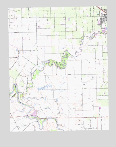
Ripon, CA USGS Topographic Map
Click on map above to begin viewing in our Map Viewer.

This topographic map contains these locations and features:
Feature Name Type Latitude Longitude GNIS ID View Map
Acacia ParkParkN37.7352°W121.1274°1828368View Map
Almond Valley Christian Reformed ChurchChurchN37.7355°W121.1355°1828370View Map
Bethany HomeBuildingN37.7388°W121.1344°1828372View Map
Blue Heron RookeryLocaleN37.6930°W121.1991°1828374View Map
Calvary Reformed ChurchChurchN37.7372°W121.1327°1828375View Map
Caswell Memorial State ParkParkN37.6933°W121.1877°220715View Map
Church of ChristChurchN37.7463°W121.1291°1828377View Map
Circle J M DairyLocaleN37.7192°W121.1981°2704822View Map
City of RiponCivilN37.7415°W121.1309°2410957View Map
Dutra FarmsLocaleN37.7361°W121.2414°2704802View Map
Finnegan FallsFallsN37.6583°W121.2302°1662129View Map
First Baptist ChurchChurchN37.7463°W121.1277°1828383View Map
First Christian Reformed ChurchChurchN37.7374°W121.1302°1828384View Map
First Congregational ChurchChurchN37.7397°W121.1283°1828385View Map
Fiscalini FarmsLocaleN37.7089°W121.1292°2559365View Map
Free Methodist ChurchChurchN37.7391°W121.1258°1828387View Map
Grace Brethren ChurchChurchN37.7394°W121.1288°1828389View Map
Harry Knoff AuditoriumBuildingN37.7399°W121.1288°1828391View Map
Heartland Community ChurchChurchN37.7394°W121.1288°1828371View Map
Hertle DairyLocaleN37.7000°W121.1611°2703316View Map
Immanuel Christian Reformed ChurchChurchN37.7355°W121.1302°1828393View Map
Jackson School (historical)SchoolN37.6883°W121.1324°1662136View Map
KVFX-FM (Manteca)TowerN37.7291°W121.1980°1665054View Map
Machado Dairy Farms Number 1LocaleN37.6994°W121.2219°2704863View Map
Mapes RanchLocaleN37.6552°W121.1913°228054View Map
Mapes Ranch AirportAirportN37.6670°W121.1967°1653744View Map
Miller LakeReservoirN37.6673°W121.2076°228741View Map
Oak ForestWoodsN37.6922°W121.1874°1828400View Map
Orthodox Christian Reformed ChurchChurchN37.7394°W121.1310°1828401View Map
Owl Rod and Gun Club (historical)LocaleN37.6566°W121.2027°1662150View Map
Quaresma DairyLocaleN37.7172°W121.2314°2704805View Map
Riley SloughStreamN37.6630°W121.2347°231590View Map
Ripon Assembly of God ChurchChurchN37.7441°W121.1269°1828402View Map
Ripon Branch Stockton-San Joaquin County Public LibraryBuildingN37.7394°W121.1285°1828403View Map
Ripon City HallBuildingN37.7427°W121.1358°1828404View Map
Ripon Elementary SchoolSchoolN37.7402°W121.1291°1828405View Map
Ripon High SchoolSchoolN37.7414°W121.1292°1828406View Map
Ripon Police DepartmentBuildingN37.7414°W121.1361°2755778View Map
Ripon Post OfficePost OfficeN37.7398°W121.1374°1828407View Map
Roest Family DairyLocaleN37.6725°W121.1567°2703424View Map
San Joaquin River National Wildlife RefugeParkN37.6284°W121.1945°2765492View Map
San Joaquin SchoolSchoolN37.7285°W121.1774°232413View Map
Stanislaus RiverStreamN37.6649°W121.2408°267673View Map
Sturgeon BendBendN37.6702°W121.2441°235628View Map
Val Martins DairyLocaleN37.6875°W121.1628°2703301View Map
Weston Elementary SchoolSchoolN37.7329°W121.1434°1828415View Map
Wilma Avenue ParkParkN37.7344°W121.1360°1828416View Map
Yandell Ranch AirportAirportN37.6405°W121.1616°1653743View Map

Note: Coordinates in the location and feature list above are referenced to NAD83 datum.


Copyright (C) 2008-2024 Ryan Niemi / Sunset Dynamics ... All Rights Reserved