TopoQuest Logo
Do you find TopoQuest useful?
Help keep TopoQuest running and adding new maps/features by donating!
Bitcoin:  19c7KJd3qBynnjoSw5npx9KScwjBe4ifkT
Litecoin:  LXs6TkuXGGXo1vDsWCkWVdjQX94eUKd6ui
Home View Maps Find Maps Find Places Resources & Links


Richland, Iowa Topographic Map

USGS Map Title: Richland, IA
USGS Map MRC: 41091B8
DRG (GeoTIFF) Download: o41091b8.tif


Neighboring USGS Topographic Map Quads:


  Harper, IA  
41092C1
 

  Keota, IA  
41091C8
 

  West Chester, IA  
41091C7
 

  Ollie, IA  
41092B1
 

  Richland, IA  
41091B8
 

  Brighton, IA  
41091B7
 

  Brookville, IA  
41092A1
 

  Fairfield North, IA  
41091A8
 

  Salina, IA  
41091A7


Map MRC Location:

N42°
W92°
N42°
W91°
H8 H7 H6 H5 H4 H3 H2 H1
G8 G7 G6 G5 G4 G3 G2 G1
F8 F7 F6 F5 F4 F3 F2 F1
E8 E7 E6 E5 E4 E3 E2 E1
D8 D7 D6 D5 D4 D3 D2 D1
C8 C7 C6 C5 C4 C3 C2 C1
B8 B7 B6 B5 B4 B3 B2 B1
A8 A7 A6 A5 A4 A3 A2 A1
N41°
W92°
N41°
W91°

Richland, IA USGS 1:24K Topographic Map Preview:
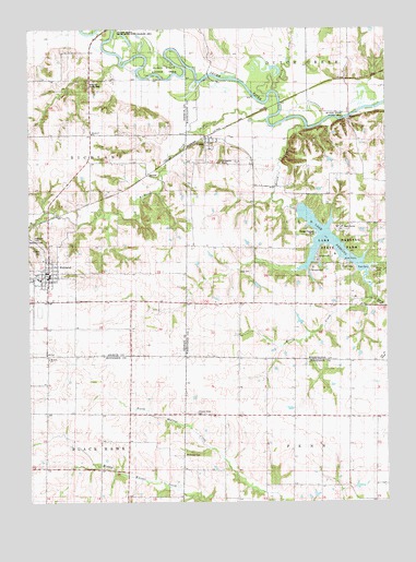
Richland, IA USGS Topographic Map
Click on map above to begin viewing in our Map Viewer.

This topographic map contains these locations and features:
Feature Name Type Latitude Longitude GNIS ID View Map
Ann Gowey CemeteryCemeteryN41.2000°W91.8974°1981810View Map
Bond Hill County ParkParkN41.2353°W91.9796°1825051View Map
Brayo (historical)LocaleN41.1625°W91.9460°1976356View Map
Brays Post Office (historical)Post OfficeN41.1625°W91.9460°1976357View Map
City of RichlandCivilN41.1857°W91.9960°2396364View Map
ClayLocaleN41.1775°W91.9268°466005View Map
Clay CemeteryCemeteryN41.1858°W91.9221°455442View Map
Clay Post Office (historical)Post OfficeN41.1322°W91.9288°466611View Map
Dutch CreekStreamN41.2325°W91.9168°456081View Map
Evergreen CemeteryCemeteryN41.2139°W91.9330°456422View Map
Friends CemeteryCemeteryN41.1917°W91.9954°456782View Map
Highland CemeteryCemeteryN41.1950°W91.9988°457454View Map
Honey CreekStreamN41.2231°W91.9032°457599View Map
Hopewell Friends ChurchChurchN41.2220°W91.9777°457654View Map
Howard Grove CemeteryCemeteryN41.1489°W91.9421°457693View Map
Lake DarlingReservoirN41.1947°W91.8971°455797View Map
Lake Darling State ParkParkN41.1917°W91.8957°458188View Map
McDowell CemeteryCemeteryN41.1381°W91.9463°458879View Map
McKain State Access AreaLocaleN41.2272°W91.8888°1825050View Map
Mother Cabrini Catholic ChurchChurchN41.1842°W91.9968°1976221View Map
RichlandPopulated PlaceN41.1856°W91.9930°460617View Map
Richland (historical)LocaleN41.1856°W91.9930°1976226View Map
Richland City HallBuildingN41.1850°W91.9946°1976224View Map
Richland CreekStreamN41.2261°W91.9163°460621View Map
Richland Fire DepartmentBuildingN41.1852°W91.9947°1976225View Map
Richland Post OfficePost OfficeN41.1850°W91.9946°1976223View Map
Richland Public LibraryBuildingN41.1847°W91.9924°1976218View Map
Richland United Methodist ChurchChurchN41.1833°W91.9943°1976219View Map
Rocky Run CemeteryCemeteryN41.2056°W91.9474°1976290View Map
RubioPopulated PlaceN41.2211°W91.9377°460841View Map
RubioLocaleN41.2214°W91.9377°1981623View Map
Rubio BridgeBridgeN41.2375°W91.9368°1981789View Map
Rubio Friends ChurchChurchN41.2186°W91.9363°460842View Map
Rubio Post Office (historical)Post OfficeN41.2211°W91.9377°1981624View Map
Rubio State Access AreaAreaN41.2392°W91.9521°464372View Map
Solid Rock FellowshipChurchN41.1853°W91.9946°1976222View Map
Township of ClayCivilN41.1964°W91.8884°467610View Map
Trinity Friends ChurchChurchN41.1847°W91.9952°1976220View Map
VeoPopulated PlaceN41.1542°W91.9080°464308View Map
Veo Post Office (historical)Post OfficeN41.1542°W91.9080°1976343View Map
Woolson (historical)LocaleN41.1633°W91.9932°1976330View Map
Woolson Friends ChurchChurchN41.1631°W91.9932°463203View Map
Woolson Post Office (historical)Post OfficeN41.1633°W91.9932°1976329View Map

Note: Coordinates in the location and feature list above are referenced to NAD83 datum.


Copyright (C) 2008-2024 Ryan Niemi / Sunset Dynamics ... All Rights Reserved