TopoQuest Logo
Do you find TopoQuest useful?
Help keep TopoQuest running and adding new maps/features by donating!
Bitcoin:  19c7KJd3qBynnjoSw5npx9KScwjBe4ifkT
Litecoin:  LXs6TkuXGGXo1vDsWCkWVdjQX94eUKd6ui
Home View Maps Find Maps Find Places Resources & Links


Richford, Vermont Topographic Map

USGS Map Title: Richford, VT
USGS Map MRC: 44072H6
DRG (GeoTIFF) Download: o44072h6.tif


Neighboring USGS Topographic Map Quads:


  Enosburg Falls, VT  
44072H7
 

  Richford, VT  
44072H6
 

  Jay Peak, VT  
44072H5
 

  Bakersfield, VT  
44072G7
 

  Cold Hollow Mountains, VT  
44072G6
 

  Hazens Notch, VT  
44072G5


Map MRC Location:

N45°
W73°
N45°
W72°
H8 H7 H6 H5 H4 H3 H2 H1
G8 G7 G6 G5 G4 G3 G2 G1
F8 F7 F6 F5 F4 F3 F2 F1
E8 E7 E6 E5 E4 E3 E2 E1
D8 D7 D6 D5 D4 D3 D2 D1
C8 C7 C6 C5 C4 C3 C2 C1
B8 B7 B6 B5 B4 B3 B2 B1
A8 A7 A6 A5 A4 A3 A2 A1
N44°
W73°
N44°
W72°

Richford, VT USGS 1:24K Topographic Map Preview:
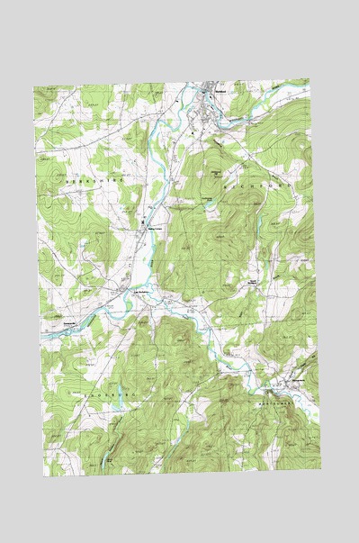
Richford, VT USGS Topographic Map
Click on map above to begin viewing in our Map Viewer.

This topographic map contains these locations and features:
Feature Name Type Latitude Longitude GNIS ID View Map
Adams PondLakeN44.8801°W72.7220°1456110View Map
All Saints CemeteryCemeteryN44.9889°W72.6796°1920521View Map
Arvin A Brown Public LibraryBuildingN44.9956°W72.6732°1920524View Map
Berkshire Fire DepartmentBuildingN44.9352°W72.7276°2121447View Map
Berkshire Municipal ForestForestN44.9584°W72.7429°1920538View Map
Black Falls BrookStreamN44.9020°W72.6457°1456443View Map
Comstock Covered BridgeBridgeN44.8995°W72.6443°1920560View Map
Downtown Richford Historic DistrictParkN44.9970°W72.6721°1920566View Map
East BerkshirePopulated PlaceN44.9353°W72.7093°1457251View Map
East Berkshire Congregational CemeteryCemeteryN44.9320°W72.7033°1920569View Map
East Berkshire Congregational ChurchChurchN44.9317°W72.7037°1920570View Map
East Berkshire Episcopal CemeteryCemeteryN44.9314°W72.7170°1920571View Map
Enosburg Town ForestForestN44.8937°W72.6910°1920599View Map
Fuller Covered BridgeBridgeN44.9034°W72.6398°1920620View Map
Guillmettes PondLakeN44.9610°W72.6716°1457670View Map
Hardwood HillSummitN44.9698°W72.6690°1457731View Map
Hopkins Covered BridgeBridgeN44.9206°W72.6735°1920656View Map
Longley Covered BridgeBridgeN44.9073°W72.6554°1920675View Map
Loveland BrookStreamN44.9850°W72.6840°1458293View Map
Missisquoi River BridgeBridgeN44.9967°W72.6712°1920693View Map
MontgomeryPopulated PlaceN44.9025°W72.6382°1458521View Map
Montgomery Post OfficePost OfficeN44.9029°W72.6392°1920698View Map
North Branch Missisquoi RiverStreamN44.9917°W72.6837°1458700View Map
Nutting CornersLocaleN44.9537°W72.6999°1458800View Map
Old CemeteryCemeteryN44.9007°W72.6366°1920715View Map
RichfordPopulated PlaceN44.9970°W72.6712°1459178View Map
Richford Census Designated PlaceCensusN44.9952°W72.6647°2378132View Map
Richford Center CemeteryCemeteryN44.9742°W72.6495°1920727View Map
Richford Elementary SchoolSchoolN44.9836°W72.6785°1920729View Map
Richford Fire DepartmentBuildingN44.9958°W72.6729°2121450View Map
Richford Junior / Senior High SchoolSchoolN44.9949°W72.6697°1920730View Map
Richford Post OfficePost OfficeN44.9952°W72.6731°1920731View Map
Richford Town HallBuildingN44.9956°W72.6732°1920732View Map
Saint Bartholomews Episcopal ChurchChurchN44.9023°W72.6393°1920753View Map
SamsonvillePopulated PlaceN44.9237°W72.7326°1459356View Map
South RichfordPopulated PlaceN44.9342°W72.6518°1459611View Map
South Richford CemeteryCemeteryN44.9329°W72.6511°1920783View Map
Town of EnosburghCivilN44.8800°W72.7480°1462090View Map
Trout RiverStreamN44.9356°W72.7012°1459956View Map
Troy Street CemeteryCemeteryN44.9915°W72.6713°1920800View Map
Village CemeteryCemeteryN44.9023°W72.6365°1920802View Map
West Hill BrookStreamN44.9023°W72.6487°1460150View Map
Whittaker BrookStreamN44.9875°W72.6532°1460241View Map

Note: Coordinates in the location and feature list above are referenced to NAD83 datum.


Copyright (C) 2008-2024 Ryan Niemi / Sunset Dynamics ... All Rights Reserved