TopoQuest Logo
Do you find TopoQuest useful?
Help keep TopoQuest running and adding new maps/features by donating!
Bitcoin:  19c7KJd3qBynnjoSw5npx9KScwjBe4ifkT
Litecoin:  LXs6TkuXGGXo1vDsWCkWVdjQX94eUKd6ui
Home View Maps Find Maps Find Places Resources & Links


Richardson Pond, Maine Topographic Map

USGS Map Title: Richardson Pond, ME
USGS Map MRC: 44070H8
DRG (GeoTIFF) Download: o44070h8.tif


Neighboring USGS Topographic Map Quads:


  Bosebuck Mountain, ME  
45071A1
 

  Lincoln Pond, ME  
45070A8
 

  Kennebago, ME  
45070A7
 

  Wilsons Mills, ME  
44071H1
 

  Richardson Pond, ME  
44070H8
 

  Oquossoc, ME  
44070H7
 

  Umbagog Lake North, NH  
44071G1
 

  Middle Dam, ME  
44070G8
 

  Metallak Mountain, ME  
44070G7


Map MRC Location:

N45°
W71°
N45°
W70°
H8 H7 H6 H5 H4 H3 H2 H1
G8 G7 G6 G5 G4 G3 G2 G1
F8 F7 F6 F5 F4 F3 F2 F1
E8 E7 E6 E5 E4 E3 E2 E1
D8 D7 D6 D5 D4 D3 D2 D1
C8 C7 C6 C5 C4 C3 C2 C1
B8 B7 B6 B5 B4 B3 B2 B1
A8 A7 A6 A5 A4 A3 A2 A1
N44°
W71°
N44°
W70°

Richardson Pond, ME USGS 1:24K Topographic Map Preview:
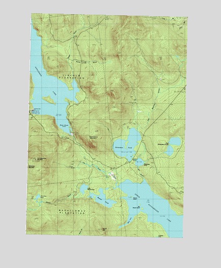
Richardson Pond, ME USGS Topographic Map
Click on map above to begin viewing in our Map Viewer.

This topographic map contains these locations and features:
Feature Name Type Latitude Longitude GNIS ID View Map
Adamstown TownshipCivilN44.9684°W70.8772°1987267View Map
Aziscohos DamDamN44.9451°W70.9970°561376View Map
Aziscohos Falls (historical)FallsN44.9444°W70.9981°2677992View Map
Aziscohos PondLakeN44.8962°W70.9910°561379View Map
Barney BrookStreamN44.9748°W70.9684°561628View Map
Beaver BrookStreamN44.9031°W70.9284°561899View Map
Beaver BrookStreamN44.9634°W70.9640°561900View Map
Beaver IslandIslandN44.8981°W70.9159°561932View Map
Beaver PondLakeN44.8959°W70.9393°561944View Map
Big Beaver IslandIslandN44.8942°W70.9090°562125View Map
Black Brook CoveBayN44.9398°W70.9740°562413View Map
Deer Mountain StreamStreamN44.9367°W70.9131°564995View Map
East Richardson PondsLakeN44.9241°W70.8869°565673View Map
Fish Pond BrookStreamN44.9023°W70.9259°566219View Map
Little Beaver PondLakeN44.9016°W70.9546°569673View Map
Low Aziscohos MountainSummitN44.9177°W70.9932°570451View Map
Mill BrookStreamN44.9073°W70.9065°571300View Map
Observatory MountainSummitN44.9276°W70.9486°572659View Map
Pepperpot PondLakeN44.9171°W70.9109°573186View Map
Plantation of LincolnCivilN44.9488°W70.9960°582560View Map
Richardson PondLakeN44.9269°W70.9206°574173View Map
Round MountainSummitN44.8787°W70.9397°574484View Map
Sunday Pond (historical)LakeN44.9440°W70.9969°576529View Map
Unorganized Territory of North OxfordCivilN44.9205°W70.9193°582634View Map
West Arm Upper Richardson LakeBayN44.8828°W70.9192°578016View Map

Note: Coordinates in the location and feature list above are referenced to NAD83 datum.


Copyright (C) 2008-2024 Ryan Niemi / Sunset Dynamics ... All Rights Reserved