TopoQuest Logo
Do you find TopoQuest useful?
Help keep TopoQuest running and adding new maps/features by donating!
Bitcoin:  19c7KJd3qBynnjoSw5npx9KScwjBe4ifkT
Litecoin:  LXs6TkuXGGXo1vDsWCkWVdjQX94eUKd6ui
Home View Maps Find Maps Find Places Resources & Links


Rice, Washington Topographic Map

USGS Map Title: Rice, WA
USGS Map MRC: 48118D2
DRG (GeoTIFF) Download: o48118d2.tif


Neighboring USGS Topographic Map Quads:


  South Huckleberry Mountain, WA  
48118E3
 

  Bangs Mountain, WA  
48118E2
 

  Kettle Falls, WA  
48118E1
 

  La Fleur Lake, WA  
48118D3
 

  Rice, WA  
48118D2
 

  Kentry Ridge, WA  
48118D1
 

  Moon Mountain, WA  
48118C3
 

  Inchelium, WA  
48118C2
 

  Wellington Peak, WA  
48118C1


Map MRC Location:

N49°
W119°
N49°
W118°
H8 H7 H6 H5 H4 H3 H2 H1
G8 G7 G6 G5 G4 G3 G2 G1
F8 F7 F6 F5 F4 F3 F2 F1
E8 E7 E6 E5 E4 E3 E2 E1
D8 D7 D6 D5 D4 D3 D2 D1
C8 C7 C6 C5 C4 C3 C2 C1
B8 B7 B6 B5 B4 B3 B2 B1
A8 A7 A6 A5 A4 A3 A2 A1
N48°
W119°
N48°
W118°

Rice, WA USGS 1:24K Topographic Map Preview:
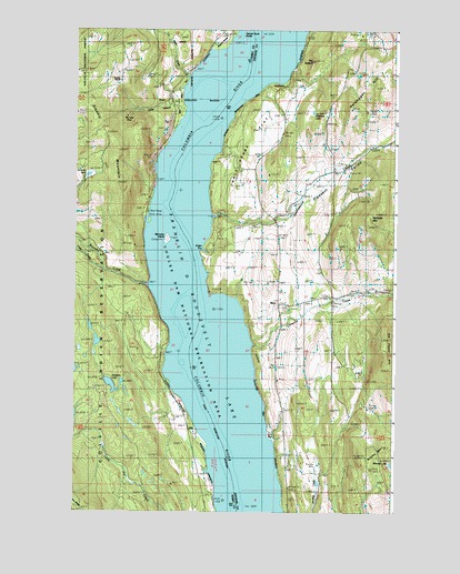
Rice, WA USGS Topographic Map
Click on map above to begin viewing in our Map Viewer.

This topographic map contains these locations and features:
Feature Name Type Latitude Longitude GNIS ID View Map
Barnaby CreekStreamN48.4341°W118.2214°1516143View Map
Barnaby IslandIslandN48.4457°W118.2144°1534611View Map
Big Lake MineMineN48.4777°W118.2286°1516528View Map
Butcher MountainSummitN48.3902°W118.1367°1517146View Map
Cedar CreekStreamN48.4382°W118.2383°1517553View Map
Chalk Grade FlatFlatN48.4666°W118.1808°1517612View Map
Cheweka CreekStreamN48.4185°W118.1797°1517675View Map
Cuba CanyonValleyN48.4780°W118.2289°1518394View Map
Cully Memorial CemeteryCemeteryN48.4277°W118.1671°1518398View Map
Harvey (historical)Populated PlaceN48.4571°W118.1928°1530579View Map
La Fleur CreekStreamN48.4882°W118.2056°1521796View Map
Mitchell LakeLakeN48.3875°W118.1267°1523294View Map
Nettleton LakeLakeN48.4786°W118.1578°1523628View Map
Nicholas LakeLakeN48.4622°W118.2451°1531548View Map
Nicholls MountainSummitN48.4513°W118.1347°1523648View Map
Pleasant ValleyValleyN48.4513°W118.1939°1524508View Map
Quillisascut CreekStreamN48.4513°W118.1939°1531081View Map
RicePopulated PlaceN48.4288°W118.1703°1525025View Map
Rice Post OfficePost OfficeN48.4286°W118.1704°2607009View Map
Rotter BayBayN48.4430°W118.1997°1528934View Map
Simpson LakeLakeN48.4078°W118.2358°1525812View Map
Staehly MountainSummitN48.4724°W118.2431°1526480View Map
Staehly RanchLocaleN48.4868°W118.2322°1526481View Map
Stahley LookoutLocaleN48.4888°W118.2494°1530414View Map
Stevens County Fire District 12 RiceBuildingN48.4281°W118.1669°2606751View Map
The SplitoffSummitN48.4921°W118.1564°1527070View Map
Victory Baptist ChurchChurchN48.4286°W118.1708°2609820View Map

Note: Coordinates in the location and feature list above are referenced to NAD83 datum.


Copyright (C) 2008-2024 Ryan Niemi / Sunset Dynamics ... All Rights Reserved