TopoQuest Logo
Do you find TopoQuest useful?
Help keep TopoQuest running and adding new maps/features by donating!
Bitcoin:  19c7KJd3qBynnjoSw5npx9KScwjBe4ifkT
Litecoin:  LXs6TkuXGGXo1vDsWCkWVdjQX94eUKd6ui
Home View Maps Find Maps Find Places Resources & Links


Reserve, New Mexico Topographic Map

USGS Map Title: Reserve, NM
USGS Map MRC: 33108F7
DRG (GeoTIFF) Download: o33108f7.tif


Neighboring USGS Topographic Map Quads:


  Luna, NM  
33108G8
 

  Dillon Mountain, NM  
33108G7
 

  Cruzville, NM  
33108G6
 

  Bull Basin, NM  
33108F8
 

  Reserve, NM  
33108F7
 

  Milligan Mountain, NM  
33108F6
 

  Saliz Pass, NM  
33108E8
 

  O Block Canyon, NM  
33108E7
 

  Sign Camp Mountain, NM  
33108E6


Map MRC Location:

N34°
W109°
N34°
W108°
H8 H7 H6 H5 H4 H3 H2 H1
G8 G7 G6 G5 G4 G3 G2 G1
F8 F7 F6 F5 F4 F3 F2 F1
E8 E7 E6 E5 E4 E3 E2 E1
D8 D7 D6 D5 D4 D3 D2 D1
C8 C7 C6 C5 C4 C3 C2 C1
B8 B7 B6 B5 B4 B3 B2 B1
A8 A7 A6 A5 A4 A3 A2 A1
N33°
W109°
N33°
W108°

Reserve, NM USGS 1:24K Topographic Map Preview:
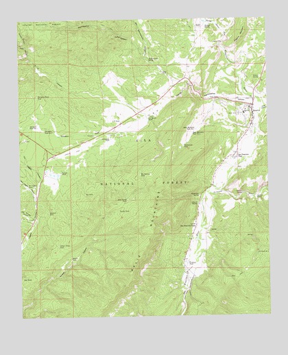
Reserve, NM USGS Topographic Map
Click on map above to begin viewing in our Map Viewer.

This topographic map contains these locations and features:
Feature Name Type Latitude Longitude GNIS ID View Map
10008 Water WellWellN33.6948°W108.8570°922699View Map
Atwood SpringSpringN33.6723°W108.7865°903459View Map
Balkie TankReservoirN33.7205°W108.8364°913208View Map
Big Pasture TankReservoirN33.6848°W108.8148°903800View Map
Burrow CanyonValleyN33.7392°W108.8720°904249View Map
Canovas SpringSpringN33.6748°W108.7566°904729View Map
Catron County Ambulance Service ReserveBuildingN33.7132°W108.7603°2657682View Map
Catron County Sheriff's OfficeBuildingN33.7124°W108.7577°2722579View Map
Church of ChristChurchN33.7131°W108.7578°920337View Map
Cibola Scout CampLocaleN33.7123°W108.8648°913207View Map
Cienega CanyonValleyN33.7437°W108.7717°905151View Map
Cordovas TankReservoirN33.6475°W108.7913°905342View Map
Deep CanyonValleyN33.7348°W108.8706°905660View Map
Dry Leggett CanyonValleyN33.6820°W108.8653°905887View Map
Dry Starkweather CanyonValleyN33.7337°W108.8120°905892View Map
FP Tank Number 4ReservoirN33.6515°W108.7565°906218View Map
Frisco SpringSpringN33.6445°W108.7945°913196View Map
Gordon TankReservoirN33.6696°W108.8258°906662View Map
Grande TankReservoirN33.6858°W108.8545°906681View Map
Griffen SpringSpringN33.7295°W108.8040°913209View Map
Griffin RanchLocaleN33.7273°W108.8028°906745View Map
Higgins MountainSummitN33.7417°W108.7637°906967View Map
Hightower SpringSpringN33.6759°W108.7856°906982View Map
Hudson RanchLocaleN33.7473°W108.7853°907149View Map
Hudson SpringSpringN33.7468°W108.7814°907150View Map
Indian Camp TankReservoirN33.6551°W108.8562°907189View Map
Largo CanyonValleyN33.7120°W108.7534°907847View Map
Lower Frisco Census Designated PlaceCensusN33.6515°W108.7894°2584146View Map
Lower Plaza Tank Number OneReservoirN33.6572°W108.8001°913195View Map
Lower Plaza Tank Number TwoReservoirN33.6672°W108.8105°913205View Map
Lower San Francisco PlazaPopulated PlaceN33.6628°W108.7873°908286View Map
Magdalena CanyonValleyN33.7009°W108.7573°913203View Map
Middle Frisco Census Designated PlaceCensusN33.6949°W108.7640°2584154View Map
Middle TankReservoirN33.6497°W108.8502°908715View Map
Negrito SpringSpringN33.6763°W108.7636°909040View Map
Oak Springs CanyonValleyN33.6673°W108.8687°909244View Map
Pollies SpringSpringN33.7252°W108.7543°909779View Map
Rancho Grande Census Designated PlaceCensusN33.6827°W108.8581°2584191View Map
Rancho Grande EstatesPopulated PlaceN33.6856°W108.8620°920787View Map
Rancho Grande Fire DepartmentBuildingN33.6802°W108.8590°2657882View Map
Ranger StationLocaleN33.7164°W108.7753°910008View Map
Rattlesnake TankReservoirN33.6966°W108.7930°910026View Map
Red TankReservoirN33.6681°W108.8284°913194View Map
ReservePopulated PlaceN33.7131°W108.7578°923657View Map
Reserve AirportAirportN33.6929°W108.8561°937007View Map
Reserve Baptist ChurchChurchN33.7131°W108.7578°921260View Map
Reserve CemeteryCemeteryN33.7135°W108.7627°931330View Map
Reserve Elementary SchoolSchoolN33.7131°W108.7578°933825View Map
Reserve High SchoolSchoolN33.7131°W108.7578°914369View Map
Reserve Natural BridgeArchN33.7392°W108.7750°2632188View Map
Reserve Post OfficePost OfficeN33.7127°W108.7589°937916View Map
Reserve Volunteer Fire DepartmentBuildingN33.7084°W108.7617°2657881View Map
Reserve Weather StationLocaleN33.7131°W108.7578°931855View Map
Rim TankReservoirN33.6412°W108.8747°910176View Map
Rivers Census Designated PlaceCensusN33.6757°W108.7768°2584193View Map
Rothlisberger RanchLocaleN33.6998°W108.8298°910435View Map
S U CanyonValleyN33.7242°W108.7906°910489View Map
S U Ranch TankReservoirN33.7081°W108.8111°910490View Map
S U SpringSpringN33.7080°W108.8121°913200View Map
S U TankReservoirN33.7075°W108.8246°910491View Map
S U Tank Number TwoReservoirN33.7141°W108.8013°913201View Map
S.U. Canyon Sand and Gravel ProspectMineN33.7103°W108.8417°917042View Map
Saddle TankReservoirN33.6256°W108.7622°913198View Map
Saliz Divide TankReservoirN33.6744°W108.8214°910562View Map
Saliz Mountain Tank Number 1ReservoirN33.7037°W108.7867°910565View Map
Saliz Mountain Tank Number 2ReservoirN33.7019°W108.7885°910566View Map
San Francisco PlazaPopulated PlaceN33.6934°W108.7662°923678View Map
Sawmill TankReservoirN33.6691°W108.8612°910853View Map
Spring TankReservoirN33.6376°W108.7673°913197View Map
Spurgeon DrawValleyN33.7103°W108.8070°911364View Map
Spurgeon Draw TankReservoirN33.7180°W108.8662°911365View Map
Spurgeon Draw TanksReservoirN33.7180°W108.8662°2038695View Map
Spurgeon Tank Number 1ReservoirN33.7046°W108.8708°911367View Map
Spurgeon Tank Number 2ReservoirN33.7036°W108.8630°911368View Map
Starkweather CanyonValleyN33.7139°W108.7526°911391View Map
Starkweather SpringSpringN33.7331°W108.8099°911392View Map
Stevens SawmillLocaleN33.6959°W108.8581°901277View Map
Stone TankReservoirN33.6746°W108.8080°913204View Map
Top TankReservoirN33.6768°W108.8428°911748View Map
Tularosa RiverStreamN33.6781°W108.7801°923710View Map
Village of ReserveCivilN33.7090°W108.7614°2413582View Map
Wee TankReservoirN33.7096°W108.7965°913202View Map
Wet Leggett CanyonValleyN33.6728°W108.8681°912277View Map
Wet Leggett TankReservoirN33.6807°W108.8715°912279View Map

Note: Coordinates in the location and feature list above are referenced to NAD83 datum.


Copyright (C) 2008-2024 Ryan Niemi / Sunset Dynamics ... All Rights Reserved