TopoQuest Logo
Do you find TopoQuest useful?
Help keep TopoQuest running and adding new maps/features by donating!
Bitcoin:  19c7KJd3qBynnjoSw5npx9KScwjBe4ifkT
Litecoin:  LXs6TkuXGGXo1vDsWCkWVdjQX94eUKd6ui
Home View Maps Find Maps Find Places Resources & Links


Red Rock, Mississippi Topographic Map

USGS Map Title: Red Rock, MS
USGS Map MRC: 32090G7
DRG (GeoTIFF) Download: o32090g7.tif


Neighboring USGS Topographic Map Quads:


  Rolling Fork West, MS  
32090H8
 

  Rolling Fork East, MS  
32090H7
 

  Bayland, MS  
32090H6
 

  Cary, MS  
32090G8
 

  Red Rock, MS  
32090G7
 

  Holly Bluff, MS  
32090G6
 

  Onward, MS  
32090F8
 

  Valley Park, MS  
32090F7
 

  Lucre, MS  
32090F6


Map MRC Location:

N33°
W91°
N33°
W90°
H8 H7 H6 H5 H4 H3 H2 H1
G8 G7 G6 G5 G4 G3 G2 G1
F8 F7 F6 F5 F4 F3 F2 F1
E8 E7 E6 E5 E4 E3 E2 E1
D8 D7 D6 D5 D4 D3 D2 D1
C8 C7 C6 C5 C4 C3 C2 C1
B8 B7 B6 B5 B4 B3 B2 B1
A8 A7 A6 A5 A4 A3 A2 A1
N32°
W91°
N32°
W90°

Red Rock, MS USGS 1:24K Topographic Map Preview:
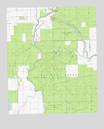
Red Rock, MS USGS Topographic Map
Click on map above to begin viewing in our Map Viewer.

This topographic map contains these locations and features:
Feature Name Type Latitude Longitude GNIS ID View Map
Barge Lake CampgroundLocaleN32.8274°W90.8104°711344View Map
Blue Lake Picnic AreaLocaleN32.8218°W90.8095°705586View Map
Blue Lake Recreation AreaParkN32.8210°W90.8090°711121View Map
Buck PointCapeN32.8615°W90.8118°692743View Map
Choctaw BayouStreamN32.8724°W90.8118°692897View Map
Choctaw LandingPopulated PlaceN32.8699°W90.8090°692900View Map
Cypress BendBendN32.8618°W90.8129°693027View Map
Fish LakeLakeN32.8162°W90.7832°711123View Map
Howlett BayouStreamN32.8201°W90.8265°693550View Map
Long Bayou-Greentree ReservoirReservoirN32.7585°W90.8098°704489View Map
Lost LakeLakeN32.8201°W90.8084°711124View Map
Red RockLocaleN32.8146°W90.7665°694533View Map
Rolling Fork CreekStreamN32.8587°W90.8315°694603View Map
Rolling Fork LandingLocaleN32.8524°W90.8337°705321View Map
Sunflower Waterfowl ProjectParkN32.8401°W90.7898°694908View Map
Sunflower-Greentree ReservoirReservoirN32.8418°W90.7918°704488View Map
Supervisor District 1CivilN32.8127°W90.8028°712060View Map

Note: Coordinates in the location and feature list above are referenced to NAD83 datum.


Copyright (C) 2008-2024 Ryan Niemi / Sunset Dynamics ... All Rights Reserved