TopoQuest Logo
Do you find TopoQuest useful?
Help keep TopoQuest running and adding new maps/features by donating!
Bitcoin:  19c7KJd3qBynnjoSw5npx9KScwjBe4ifkT
Litecoin:  LXs6TkuXGGXo1vDsWCkWVdjQX94eUKd6ui
Home View Maps Find Maps Find Places Resources & Links


Red Rock, Pennsylvania Topographic Map

USGS Map Title: Red Rock, PA
USGS Map MRC: 41076C3
DRG (GeoTIFF) Download: o41076c3.tif


Neighboring USGS Topographic Map Quads:


  Laporte, PA  
41076D4
 

  Lopez, PA  
41076D3
 

  Dutch Mountain, PA  
41076D2
 

  Elk Grove, PA  
41076C4
 

  Red Rock, PA  
41076C3
 

  Sweet Valley, PA  
41076C2
 

  Benton, PA  
41076B4
 

  Stillwater, PA  
41076B3
 

  Shickshinny, PA  
41076B2


Map MRC Location:

N42°
W77°
N42°
W76°
H8 H7 H6 H5 H4 H3 H2 H1
G8 G7 G6 G5 G4 G3 G2 G1
F8 F7 F6 F5 F4 F3 F2 F1
E8 E7 E6 E5 E4 E3 E2 E1
D8 D7 D6 D5 D4 D3 D2 D1
C8 C7 C6 C5 C4 C3 C2 C1
B8 B7 B6 B5 B4 B3 B2 B1
A8 A7 A6 A5 A4 A3 A2 A1
N41°
W77°
N41°
W76°

Red Rock, PA USGS 1:24K Topographic Map Preview:
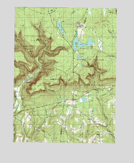
Red Rock, PA USGS Topographic Map
Click on map above to begin viewing in our Map Viewer.

This topographic map contains these locations and features:
Feature Name Type Latitude Longitude GNIS ID View Map
Adams FallsFallsN41.2995°W76.2742°1201523View Map
Ashelman RunStreamN41.2751°W76.3322°1168447View Map
B Reynolds FallsFallsN41.3233°W76.2744°1201532View Map
Bear SwampSwampN41.3722°W76.3283°1168947View Map
Beaver PondLakeN41.2903°W76.2886°1201522View Map
Benton Air Force StationMilitaryN41.3582°W76.2947°2512047View Map
Benton Air Force Station (historical)MilitaryN41.3583°W76.2950°2086910View Map
Big RunStreamN41.3362°W76.3391°1169570View Map
Blackberry RunStreamN41.3095°W76.3544°1169750View Map
Boston RunStreamN41.2970°W76.2730°1170025View Map
Boston Run Nature AreaAreaN41.2967°W76.2730°1201524View Map
Brish RunStreamN41.2534°W76.2938°1170272View Map
Cayuga FallsFallsN41.3253°W76.2850°1201543View Map
CentralPopulated PlaceN41.2967°W76.3730°1171478View Map
Central MountainSummitN41.3001°W76.3463°1198272View Map
Cherry RidgeRidgeN41.3612°W76.2713°1171653View Map
Chimneystack RockSummitN41.2987°W76.3374°1171789View Map
Chimneystack RunStreamN41.2867°W76.3205°1171790View Map
Conestoga FallsFallsN41.3214°W76.2817°1201538View Map
Crooked CreekStreamN41.2884°W76.2688°1192314View Map
Delaware FallsFallsN41.3222°W76.2831°1201540View Map
East Branch Fishing CreekStreamN41.2756°W76.3747°1209360View Map
Erie FallsFallsN41.3216°W76.2776°1201708View Map
F L Ricketts FallsFallsN41.3295°W76.2738°1201527View Map
Fairmount SpringsLocaleN41.2512°W76.3083°1212583View Map
Fairmount Township Volunteer Fire and AmbulanceBuildingN41.3023°W76.2528°2652819View Map
Fallow HollowValleyN41.2631°W76.3408°1174597View Map
Fishing Creek GorgeValleyN41.3006°W76.3681°1201307View Map
Fritz HillSummitN41.2684°W76.3599°1214712View Map
Ganoga FallsFallsN41.3239°W76.2839°1201542View Map
Ganoga GlenValleyN41.3213°W76.2756°1175415View Map
Ganoga LakeLakeN41.3564°W76.3186°1175416View Map
Glen LeighAreaN41.3201°W76.2752°1201546View Map
Glen Leigh ValleyValleyN41.3214°W76.2754°1175697View Map
Grand ViewSummitN41.3084°W76.3097°1201384View Map
Grand View Fire TowerTowerN41.3084°W76.3097°1205233View Map
Grassy HollowValleyN41.3271°W76.3483°1175988View Map
Harrison Wright FallsFallsN41.3207°W76.2752°1201534View Map
Heberly RunStreamN41.3259°W76.3449°1176737View Map
Hess HollowValleyN41.2629°W76.3471°1176910View Map
Hunts RunStreamN41.3448°W76.3402°1177634View Map
Huron FallsFallsN41.3267°W76.2743°1201529View Map
Jamison CityPopulated PlaceN41.3065°W76.3608°1177983View Map
Jamison City Census Designated PlaceCensusN41.2983°W76.3690°2389979View Map
Kitchen Creek FallsFallsN41.2992°W76.2738°1178568View Map
Kitchen Creek GorgeValleyN41.2973°W76.2730°1201306View Map
Lake JeanLakeN41.3420°W76.2924°1177996View Map
Lake JeanReservoirN41.3515°W76.2997°1195492View Map
Lake Jean DamDamN41.3491°W76.2988°1195493View Map
Lake LeighSwampN41.3414°W76.2696°1192771View Map
Lake RoseReservoirN41.3291°W76.2950°1185462View Map
Lead RunStreamN41.3206°W76.3433°1179079View Map
Lewis FallsFallsN41.3383°W76.3642°1179237View Map
Maple RunStreamN41.2659°W76.2599°1180363View Map
Maple Spring BrookStreamN41.3095°W76.2758°1180366View Map
Marsh RunStreamN41.2845°W76.3219°1180455View Map
Midway CrevasseValleyN41.3300°W76.2769°1201876View Map
Mohawk FallsFallsN41.3264°W76.2872°1201545View Map
Mohican FallsFallsN41.3217°W76.2828°1201539View Map
MossvillePopulated PlaceN41.2720°W76.2791°1204215View Map
Murray Reynolds FallsFallsN41.3183°W76.2740°1201536View Map
North Mountain Volunteer Fire Company Station 260BuildingN41.2980°W76.3742°2653338View Map
Old Bulldozer Road TrailTrailN41.3117°W76.2652°1205248View Map
Oneida FallsFallsN41.3267°W76.2872°1201544View Map
Onondaga FallsFallsN41.3312°W76.2738°1201526View Map
Opperman PassGapN41.3709°W76.2560°1213642View Map
Ore RunStreamN41.3545°W76.3438°1183030View Map
Ozone FallsFallsN41.3256°W76.2747°1201530View Map
Pigeon RunStreamN41.3412°W76.3352°1183721View Map
Quinn RunStreamN41.3384°W76.3644°1193168View Map
R B Ricketts FallsFallsN41.3243°W76.2744°1201531View Map
Red HillPopulated PlaceN41.2576°W76.2688°1204469View Map
Red RockPopulated PlaceN41.2898°W76.3013°1204473View Map
Red Rock MountainSummitN41.3104°W76.3252°1184778View Map
Ricketts GlenAreaN41.3117°W76.2647°1201525View Map
Ricketts Glen State ParkParkN41.3262°W76.2791°1199942View Map
Seneca FallsFallsN41.3228°W76.2831°1201541View Map
Shanty RunStreamN41.3442°W76.3683°1187367View Map
Shawnee FallsFallsN41.3279°W76.2738°1201528View Map
Sheldon Reynolds FallsFallsN41.3192°W76.2744°1201535View Map
Shingle Cabin BrookStreamN41.3156°W76.2730°1187530View Map
Sugarloaf Community Rescue and AmbulanceBuildingN41.2976°W76.3742°2722244View Map
Sullivan BranchStreamN41.3259°W76.3449°1189000View Map
The GlensValleyN41.3209°W76.2752°1202367View Map
The Red RockPillarN41.3137°W76.3005°1202368View Map
Township of FairmountCivilN41.2893°W76.2682°1216711View Map
Township of SugarloafCivilN41.2715°W76.3626°1216295View Map
Tri MillsPopulated PlaceN41.2617°W76.3455°1204828View Map
Trout RunStreamN41.3145°W76.3477°1189854View Map
Tuscarora FallsFallsN41.3214°W76.2795°1201537View Map
Twin FallsFallsN41.3342°W76.3563°1190005View Map
West Branch Fishing CreekStreamN41.2754°W76.3749°1193629View Map
Wyandot FallsFallsN41.3222°W76.2750°1201533View Map

Note: Coordinates in the location and feature list above are referenced to NAD83 datum.


Copyright (C) 2008-2024 Ryan Niemi / Sunset Dynamics ... All Rights Reserved