TopoQuest Logo
Do you find TopoQuest useful?
Help keep TopoQuest running and adding new maps/features by donating!
Bitcoin:  19c7KJd3qBynnjoSw5npx9KScwjBe4ifkT
Litecoin:  LXs6TkuXGGXo1vDsWCkWVdjQX94eUKd6ui
Home View Maps Find Maps Find Places Resources & Links


Raymondville, Missouri Topographic Map

USGS Map Title: Raymondville, MO
USGS Map MRC: 37091C7
DRG (GeoTIFF) Download: o37091c7.tif


Neighboring USGS Topographic Map Quads:


  Prescott, MO  
37091D8
 

  Licking, MO  
37091D7
 

  Montauk, MO  
37091D6
 

  Houston, MO  
37091C8
 

  Raymondville, MO  
37091C7
 

  Hartshorn, MO  
37091C6
 

  Elk Creek, MO  
37091B8
 

  Eunice, MO  
37091B7
 

  Summersville, MO  
37091B6


Map MRC Location:

N38°
W92°
N38°
W91°
H8 H7 H6 H5 H4 H3 H2 H1
G8 G7 G6 G5 G4 G3 G2 G1
F8 F7 F6 F5 F4 F3 F2 F1
E8 E7 E6 E5 E4 E3 E2 E1
D8 D7 D6 D5 D4 D3 D2 D1
C8 C7 C6 C5 C4 C3 C2 C1
B8 B7 B6 B5 B4 B3 B2 B1
A8 A7 A6 A5 A4 A3 A2 A1
N37°
W92°
N37°
W91°

Raymondville, MO USGS 1:24K Topographic Map Preview:
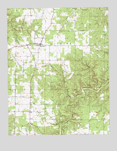
Raymondville, MO USGS Topographic Map
Click on map above to begin viewing in our Map Viewer.

This topographic map contains these locations and features:
Feature Name Type Latitude Longitude GNIS ID View Map
Allen CemeteryCemeteryN37.3214°W91.8551°713213View Map
Bear Claw SpringSpringN37.2609°W91.8143°713785View Map
Bradford Cave HollowValleyN37.2948°W91.7635°714611View Map
Friendship SchoolSchoolN37.3520°W91.7793°718248View Map
High Point SchoolSchoolN37.3092°W91.7896°719544View Map
Hobbs BranchStreamN37.2864°W91.8018°719643View Map
Kelly HollowValleyN37.3564°W91.8671°720518View Map
Pond Spring BranchStreamN37.2842°W91.7888°724735View Map
Rabbit HollowValleyN37.3095°W91.8096°725036View Map
RaymondvillePopulated PlaceN37.3398°W91.8340°725134View Map
Raymondville Fire DepartmentBuildingN37.3379°W91.8271°2621036View Map
Raymondville Post OfficePost OfficeN37.3406°W91.8333°2782938View Map
Town of RaymondvilleCivilN37.3398°W91.8365°2396870View Map
Township of JacksonCivilN37.3621°W91.7690°767468View Map
YukonPopulated PlaceN37.2731°W91.8482°729215View Map
Yukon SchoolSchoolN37.2723°W91.8388°729216View Map

Note: Coordinates in the location and feature list above are referenced to NAD83 datum.


Copyright (C) 2008-2024 Ryan Niemi / Sunset Dynamics ... All Rights Reserved