TopoQuest Logo
Do you find TopoQuest useful?
Help keep TopoQuest running and adding new maps/features by donating!
Bitcoin:  19c7KJd3qBynnjoSw5npx9KScwjBe4ifkT
Litecoin:  LXs6TkuXGGXo1vDsWCkWVdjQX94eUKd6ui
Home View Maps Find Maps Find Places Resources & Links


Big Flats, New York Topographic Map

USGS Map Title: Big Flats, NY
USGS Map MRC: 42076B8
DRG (GeoTIFF) Download: o42076b8.tif


Neighboring USGS Topographic Map Quads:


  Bradford, NY  
42077C1
 

  Beaver Dams, NY  
42076C8
 

  Montour Falls, NY  
42076C7
 

  Corning, NY  
42077B1
 

  Big Flats, NY  
42076B8
 

  Horseheads, NY  
42076B7
 

  Caton, NY  
42077A1
 

  Seeley Creek, NY  
42076A8
 

  Elmira, NY  
42076A7


Map MRC Location:

N43°
W77°
N43°
W76°
H8 H7 H6 H5 H4 H3 H2 H1
G8 G7 G6 G5 G4 G3 G2 G1
F8 F7 F6 F5 F4 F3 F2 F1
E8 E7 E6 E5 E4 E3 E2 E1
D8 D7 D6 D5 D4 D3 D2 D1
C8 C7 C6 C5 C4 C3 C2 C1
B8 B7 B6 B5 B4 B3 B2 B1
A8 A7 A6 A5 A4 A3 A2 A1
N42°
W77°
N42°
W76°

Big Flats, NY USGS 1:24K Topographic Map Preview:
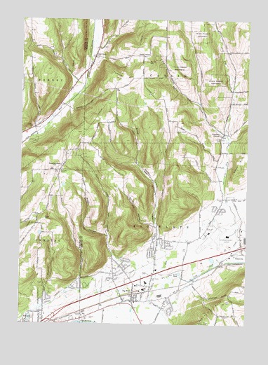
Big Flats, NY USGS Topographic Map
Click on map above to begin viewing in our Map Viewer.

This topographic map contains these locations and features:
Feature Name Type Latitude Longitude GNIS ID View Map
American Baptist Community ChurchChurchN42.1532°W76.9246°2597496View Map
Big FlatsPopulated PlaceN42.1373°W76.9369°943883View Map
Big Flats Airport Census Designated PlaceCensusN42.1693°W76.8898°2389209View Map
Big Flats Census Designated PlaceCensusN42.1621°W76.9015°2389210View Map
Big Flats LibraryBuildingN42.1401°W76.9365°2598557View Map
Big Flats Post OfficePost OfficeN42.1414°W76.9346°2598526View Map
Big Flats SchoolSchoolN42.1422°W76.9301°2597252View Map
Big Flats Town HallBuildingN42.1404°W76.9333°2598548View Map
Big Flats Volunteer Fire CompanyBuildingN42.1413°W76.9329°2734823View Map
Big Flats Wesleyan ChurchChurchN42.1411°W76.9283°2516342View Map
Breed HollowValleyN42.1606°W76.9242°944676View Map
Catlin United Methodist ChurchChurchN42.2033°W76.8878°2514272View Map
Chemung Feeder CanalCanalN42.1392°W76.9733°946478View Map
Chemung Valley Montessori SchoolSchoolN42.1365°W76.9293°2597209View Map
CollingwoodPopulated PlaceN42.2008°W76.8886°2514280View Map
Cuthrie RunStreamN42.1292°W76.9200°947965View Map
Eacher HollowValleyN42.1662°W76.9261°948904View Map
East CorningPopulated PlaceN42.1256°W76.9864°949047View Map
Elmira Corning Regional Airport Fire DepartmentBuildingN42.1622°W76.8962°2734825View Map
Elmira/Corning Regional AirportAirportN42.1630°W76.8953°975787View Map
First Presbyterian ChurchChurchN42.1350°W76.9350°2516343View Map
Friends of the Cross ChristianChurchN42.1274°W76.9851°2598026View Map
Gibson Volunteer Fire Department Station 2BuildingN42.1632°W76.9942°2735290View Map
Goff Road Mobile Home ParkPopulated PlaceN42.1280°W76.9876°2599101View Map
Hillview United Methodist ChurchChurchN42.1489°W76.9450°2516344View Map
Lowe PondLakeN42.1460°W76.9118°956065View Map
Madison CreekStreamN42.2001°W76.8855°956255View Map
Martin HillSummitN42.2326°W76.9302°956585View Map
Miller CemeteryCemeteryN42.1355°W76.9356°2514412View Map
Mills CemeteryCemeteryN42.1344°W76.8835°957347View Map
Mud DitchCanalN42.1454°W76.9166°958012View Map
National Warplane MuseumBuildingN42.1677°W76.8885°2599625View Map
Oldfield CemeteryCemeteryN42.2055°W76.9935°959336View Map
Owen HollowValleyN42.1517°W76.9458°959674View Map
Pioneer CemeteryCemeteryN42.1560°W76.9077°951278View Map
Post CreekPopulated PlaceN42.2351°W76.9600°970496View Map
Post Creek CemeteryCemeteryN42.2347°W76.9589°2514406View Map
Quackenbush HillSummitN42.1879°W76.9814°962023View Map
Quackenbush Hill Baptist ChurchChurchN42.1881°W76.9786°2597950View Map
Reasor HollowValleyN42.1612°W76.9516°962262View Map
Rose HillSummitN42.1687°W76.9866°962908View Map
Rural Home CemeteryCemeteryN42.1436°W76.9278°963094View Map
Smith CornersLocaleN42.2354°W76.9336°965470View Map
South School CemeteryCemeteryN42.2044°W76.9145°965868View Map
Spruce Run Tree FarmLocaleN42.2364°W76.9456°2516963View Map
Tompkins CornersPopulated PlaceN42.2034°W76.8877°967638View Map
Town of Big FlatsCivilN42.1387°W76.9138°978732View Map
Town of CatlinCivilN42.2449°W76.9056°978800View Map
Townley HillSummitN42.2267°W76.9466°967716View Map
Unitarian FellowshipChurchN42.1456°W76.9283°2516345View Map
Whitney CemeteryCemeteryN42.1769°W76.8885°971181View Map
Willowcreek Golf ClubLocaleN42.1290°W76.9430°2598560View Map
Willows Course at Willowcreek Golf ClubLocaleN42.1290°W76.9430°2598561View Map
Winfield CreekStreamN42.1317°W76.9869°971481View Map

Note: Coordinates in the location and feature list above are referenced to NAD83 datum.


Copyright (C) 2008-2024 Ryan Niemi / Sunset Dynamics ... All Rights Reserved