TopoQuest Logo
Do you find TopoQuest useful?
Help keep TopoQuest running and adding new maps/features by donating!
Bitcoin:  19c7KJd3qBynnjoSw5npx9KScwjBe4ifkT
Litecoin:  LXs6TkuXGGXo1vDsWCkWVdjQX94eUKd6ui
Home View Maps Find Maps Find Places Resources & Links


Raquette River, New York Topographic Map

USGS Map Title: Raquette River, NY
USGS Map MRC: 44074H7
DRG (GeoTIFF) Download: o44074h7.tif


Neighboring USGS Topographic Map Quads:


  Cornwall West, ON  
45074A7


  Massena, NY  
44074H8
 

  Raquette River, NY  
44074H7
 

  Hogansburg, NY  
44074H6
 

  Norfolk, NY  
44074G8
 

  Brasher Falls, NY  
44074G7
 

  North Lawrence, NY  
44074G6


Map MRC Location:

N45°
W75°
N45°
W74°
H8 H7 H6 H5 H4 H3 H2 H1
G8 G7 G6 G5 G4 G3 G2 G1
F8 F7 F6 F5 F4 F3 F2 F1
E8 E7 E6 E5 E4 E3 E2 E1
D8 D7 D6 D5 D4 D3 D2 D1
C8 C7 C6 C5 C4 C3 C2 C1
B8 B7 B6 B5 B4 B3 B2 B1
A8 A7 A6 A5 A4 A3 A2 A1
N44°
W75°
N44°
W74°

Raquette River, NY USGS 1:24K Topographic Map Preview:
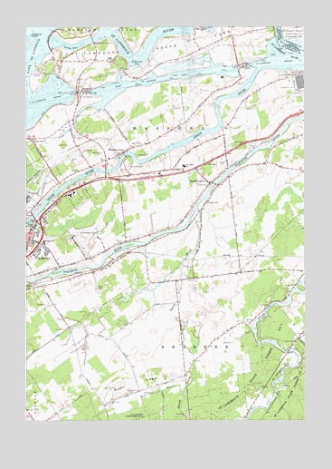
Raquette River, NY USGS Topographic Map
Click on map above to begin viewing in our Map Viewer.

This topographic map contains these locations and features:
Feature Name Type Latitude Longitude GNIS ID View Map
Barnhart Island BridgeBridgeN44.9959°W74.8452°975922View Map
Carville CemeteryCemeteryN44.9176°W74.7537°976083View Map
Dike Number FourLeveeN44.9828°W74.8571°975857View Map
Dike Number ThreeLeveeN44.9753°W74.8588°975856View Map
Earls CreekStreamN44.9245°W74.8049°976268View Map
Eisenhower LockPillarN44.9792°W74.8496°976288View Map
Fox Hill Golf and Country ClubLocaleN44.9269°W74.8594°2599048View Map
Grass RiverStreamN44.9870°W74.7702°977224View Map
Hawkins Point LookoutLocaleN44.9998°W74.7971°976417View Map
Highland Nursing HomeBuildingN44.9465°W74.8546°2599036View Map
Jefferson Elementary SchoolSchoolN44.9320°W74.8669°976489View Map
Kingdom Hall of Jehovahs WitnessesChurchN44.9321°W74.8694°2597593View Map
Long Sault DamDamN44.9967°W74.8641°976594View Map
Long Sault IslandsIslandN44.9953°W74.8730°975866View Map
Long Sault LookoutLocaleN44.9848°W74.8683°976596View Map
Maple RidgeRidgeN44.8864°W74.8266°976625View Map
Massena CenterPopulated PlaceN44.9600°W74.8313°976636View Map
Massena Center CemeteryCemeteryN44.9587°W74.8341°2417070View Map
Massena International Airport-Richards FieldAirportN44.9333°W74.8430°975796View Map
Massena Rescue SquadLocaleN44.9381°W74.8702°975854View Map
Massena Village Wastewater Treatment PlantLocaleN44.9366°W74.8742°2597246View Map
Massena Volunteer Emergency UnitBuildingN44.9355°W74.8717°2720108View Map
Nevins CemeteryCemeteryN44.9310°W74.8327°976716View Map
Polly GutGutN44.9948°W74.7618°976843View Map
Pollys BayBayN44.9931°W74.8546°976844View Map
Pollys CreekStreamN44.9925°W74.8546°976845View Map
Raquette RiverPopulated PlaceN44.9512°W74.7938°976874View Map
Raquette River BridgeBridgeN44.9503°W74.7906°2614974View Map
Reed CemeteryCemeteryN44.9435°W74.8697°2417069View Map
Robinson BayBayN44.9884°W74.8255°976897View Map
Robinson CreekStreamN44.9756°W74.8407°976899View Map
RT Seaway Eisenhower Vessel Traffic ControlLocaleN44.9795°W74.8513°975855View Map
Saint Joseph Roman Catholic ChurchChurchN44.9322°W74.8736°2417062View Map
Saint Josephs SchoolSchoolN44.9317°W74.8724°976926View Map
Saint Lawrence Center Shopping CenterLocaleN44.9487°W74.8400°2598995View Map
Saint Lawrence State Forest Number 10ForestN44.8762°W74.8260°976930View Map
Saint Lawrence State Forest Number 6ForestN44.8903°W74.7710°976936View Map
Saint Lawrence State ParkParkN44.9928°W74.8263°976939View Map
School Number 10 (historical)SchoolN44.8853°W74.8206°2120512View Map
School Number 11 (historical)SchoolN44.9194°W74.8078°2120513View Map
School Number 12 (historical)SchoolN44.9778°W74.8589°2120514View Map
School Number 13 (historical)SchoolN44.9253°W74.8353°2120515View Map
School Number 15 (historical)SchoolN44.8989°W74.8522°2120516View Map
School Number 17 (historical)SchoolN44.8994°W74.7553°2120517View Map
School Number 2 (historical)SchoolN44.9314°W74.8297°2120508View Map
School Number 3 (historical)SchoolN44.9517°W74.7906°2120509View Map
School Number 6 (historical)SchoolN44.9958°W74.8067°2120510View Map
School Number 7 (historical)SchoolN44.9022°W74.7869°2120511View Map
Snell LockPillarN44.9878°W74.7777°977016View Map
Squeak BrookStreamN44.9420°W74.7982°977050View Map
Sunset Drive-In (historical)LocaleN44.9556°W74.8289°2558372View Map
Town of MassenaCivilN44.9609°W74.8339°979205View Map
Twin River SchoolSchoolN44.9562°W74.8044°977158View Map
West Branch Squeak BrookStreamN44.8856°W74.8032°977200View Map
Wiley Dondero CanalCanalN44.9850°W74.8007°977276View Map

Note: Coordinates in the location and feature list above are referenced to NAD83 datum.


Copyright (C) 2008-2024 Ryan Niemi / Sunset Dynamics ... All Rights Reserved