TopoQuest Logo
Do you find TopoQuest useful?
Help keep TopoQuest running and adding new maps/features by donating!
Bitcoin:  19c7KJd3qBynnjoSw5npx9KScwjBe4ifkT
Litecoin:  LXs6TkuXGGXo1vDsWCkWVdjQX94eUKd6ui
Home View Maps Find Maps Find Places Resources & Links


Pullman, Washington Topographic Map

USGS Map Title: Pullman, WA
USGS Map MRC: 46117F2
DRG (GeoTIFF) Download: o46117f2.tif


Neighboring USGS Topographic Map Quads:


  Colfax South, WA  
46117G3
 

  Albion, WA  
46117G2
 

  Viola, ID  
46117G1
 

  Ewartsville, WA  
46117F3
 

  Pullman, WA  
46117F2
 

  Moscow West, ID  
46117F1
 

  Granite Point, WA  
46117E3
 

  Colton, WA  
46117E2
 

  Uniontown, WA  
46117E1


Map MRC Location:

N47°
W118°
N47°
W117°
H8 H7 H6 H5 H4 H3 H2 H1
G8 G7 G6 G5 G4 G3 G2 G1
F8 F7 F6 F5 F4 F3 F2 F1
E8 E7 E6 E5 E4 E3 E2 E1
D8 D7 D6 D5 D4 D3 D2 D1
C8 C7 C6 C5 C4 C3 C2 C1
B8 B7 B6 B5 B4 B3 B2 B1
A8 A7 A6 A5 A4 A3 A2 A1
N46°
W118°
N46°
W117°

Pullman, WA USGS 1:24K Topographic Map Preview:
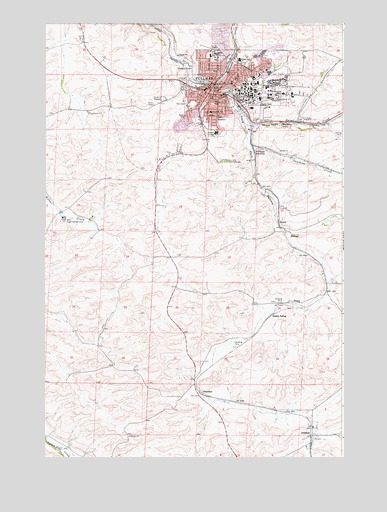
Pullman, WA USGS Topographic Map
Click on map above to begin viewing in our Map Viewer.

This topographic map contains these locations and features:
Feature Name Type Latitude Longitude GNIS ID View Map
BusbyPopulated PlaceN46.6924°W117.1504°1510853View Map
ChambersPopulated PlaceN46.6429°W117.1846°1534574View Map
City of PullmanCivilN46.7342°W117.1661°2411502View Map
Edison SchoolSchoolN46.7399°W117.1679°1504683View Map
Farr CemeteryCemeteryN46.7268°W117.1911°1504833View Map
Franklin Elementary SchoolSchoolN46.7174°W117.1708°1530890View Map
Jefferson Elementary SchoolSchoolN46.7407°W117.1811°1530943View Map
JohnsonPopulated PlaceN46.6316°W117.1379°1512333View Map
KQQQ-AM (Pullman)TowerN46.7271°W117.2071°1534284View Map
KWSU-AM (Pullman)TowerN46.6963°W117.2466°1534285View Map
KZUU-FM (Pullman)TowerN46.7307°W117.1532°1534366View Map
Lincoln Middle SchoolSchoolN46.7182°W117.1784°1530974View Map
Missouri Flat CreekStreamN46.7332°W117.1816°1506739View Map
Paradise CreekStreamN46.7208°W117.1659°388177View Map
PullmanPopulated PlaceN46.7313°W117.1796°1531905View Map
Pullman Christian SchoolSchoolN46.7224°W117.1878°1515581View Map
Pullman City CemeteryCemeteryN46.7105°W117.1758°2767963View Map
Pullman DivisionCivilN46.7271°W117.1860°1939604View Map
Pullman Fire Department Station 31BuildingN46.7251°W117.1854°2619339View Map
Pullman High SchoolSchoolN46.7479°W117.1861°1515578View Map
Pullman JunctionPopulated PlaceN46.7141°W117.1610°1511245View Map
Pullman Police DepartmentBuildingN46.7283°W117.1796°2721891View Map
Pullman Post OfficePost OfficeN46.7196°W117.1845°2769205View Map
Pullman Regional HospitalHospitalN46.7125°W117.1697°2625473View Map
Rogers Field (historical)ParkN46.7318°W117.1602°1507898View Map
Royal Garrison SchoolSchoolN46.7307°W117.1838°1515338View Map
StaleyPopulated PlaceN46.6696°W117.1485°1511332View Map
Staley Airport (historical)AirportN46.6579°W117.1677°1533903View Map
Staley SidingLocaleN46.6660°W117.1552°1508680View Map
Sunnyside Elementary SchoolSchoolN46.7271°W117.1883°1515579View Map
Sunshine CreekStreamN46.7157°W117.1638°1508846View Map
Washington State UniversitySchoolN46.7304°W117.1582°1509312View Map
Wheatland Shopping CenterLocaleN46.7152°W117.1818°1512903View Map
WhitlowPopulated PlaceN46.7213°W117.1502°1511427View Map
Whitman County Fire District 12 Station 12 - 1BuildingN46.7311°W117.1921°2643733View Map
Whitman County Fire District 12 Station 12 - 2BuildingN46.6313°W117.1369°2643697View Map
Wilma (historical)Populated PlaceN46.6816°W117.1493°1511573View Map
Woodcroft ParkParkN46.7271°W117.1791°1509616View Map

Note: Coordinates in the location and feature list above are referenced to NAD83 datum.


Copyright (C) 2008-2024 Ryan Niemi / Sunset Dynamics ... All Rights Reserved