TopoQuest Logo
Do you find TopoQuest useful?
Help keep TopoQuest running and adding new maps/features by donating!
Bitcoin:  19c7KJd3qBynnjoSw5npx9KScwjBe4ifkT
Litecoin:  LXs6TkuXGGXo1vDsWCkWVdjQX94eUKd6ui
Home View Maps Find Maps Find Places Resources & Links


Puertecito, New Mexico Topographic Map

USGS Map Title: Puertecito, NM
USGS Map MRC: 34107D4
DRG (GeoTIFF) Download: o34107d4.tif


Neighboring USGS Topographic Map Quads:


  Pueblo Viejo Mesa, NM  
34107E5
 

  Field Ranch, NM  
34107E4
 

  Puerto De Los Cavadores, NM  
34107E3
 

  Table Mountain, NM  
34107D5
 

  Puertecito, NM  
34107D4
 

  La Jara Peak, NM  
34107D3
 

  Indian Mesa, NM  
34107C5
 

  Indian Spring Canyon, NM  
34107C4
 

  Mesa Cencerro, NM  
34107C3


Map MRC Location:

N35°
W108°
N35°
W107°
H8 H7 H6 H5 H4 H3 H2 H1
G8 G7 G6 G5 G4 G3 G2 G1
F8 F7 F6 F5 F4 F3 F2 F1
E8 E7 E6 E5 E4 E3 E2 E1
D8 D7 D6 D5 D4 D3 D2 D1
C8 C7 C6 C5 C4 C3 C2 C1
B8 B7 B6 B5 B4 B3 B2 B1
A8 A7 A6 A5 A4 A3 A2 A1
N34°
W108°
N34°
W107°

Puertecito, NM USGS 1:24K Topographic Map Preview:
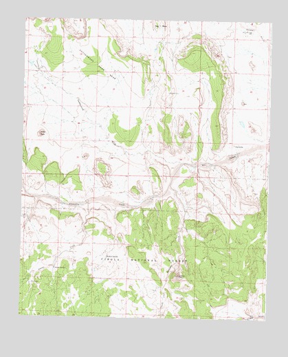
Puertecito, NM USGS Topographic Map
Click on map above to begin viewing in our Map Viewer.

This topographic map contains these locations and features:
Feature Name Type Latitude Longitude GNIS ID View Map
26-15-1 Water WellWellN34.3939°W107.4578°925845View Map
26-17-1 Water WellWellN34.4051°W107.4056°925545View Map
26-9-1 Water WellWellN34.4064°W107.4728°925546View Map
A-5 Water WellWellN34.4153°W107.4975°925838View Map
A-6 Water WellWellN34.4262°W107.4523°925552View Map
A-8 Water WellWellN34.3753°W107.4473°925668View Map
Abbe Spring CanyonValleyN34.3762°W107.3789°902931View Map
Alamo CreekStreamN34.4228°W107.4664°903043View Map
Alamo Navajo Emergency Medical ServicesBuildingN34.4165°W107.4969°2657670View Map
Alamo Navajo Reservation (historical)CivilN34.4001°W107.4506°912566View Map
Alamo SpringSpringN34.3954°W107.4825°903048View Map
Apache WellWellN34.3892°W107.4945°903243View Map
Bill Dobbs WellWellN34.4953°W107.3850°903822View Map
Chavez CreekStreamN34.3901°W107.4262°905055View Map
Chavez RanchLocaleN34.3764°W107.3806°905058View Map
Chavez Water WellWellN34.3767°W107.3812°925669View Map
Cottonwood DrawValleyN34.4398°W107.4195°905421View Map
Cottonwood Draw MesaSummitN34.4962°W107.4884°905422View Map
Jaralosa CreekStreamN34.4306°W107.4250°907312View Map
John Padilla SettlementPopulated PlaceN34.3842°W107.4745°914090View Map
La Cruz PeakSummitN34.3928°W107.4200°907625View Map
Navajo Community HallLocaleN34.4176°W107.4981°909024View Map
Piezomet 1 Water WellWellN34.4251°W107.4298°925551View Map
Piezomet 2 Water WellWellN34.4273°W107.4295°925830View Map
Pino Water WellWellN34.4217°W107.4653°925550View Map
PuertecitoPopulated PlaceN34.4481°W107.3928°923653View Map
Puertecito Post Office (historical)Post OfficeN34.4481°W107.3928°938225View Map
Richard SpringSpringN34.4003°W107.4564°910160View Map
White PeakSummitN34.4514°W107.4912°912318View Map

Note: Coordinates in the location and feature list above are referenced to NAD83 datum.


Copyright (C) 2008-2024 Ryan Niemi / Sunset Dynamics ... All Rights Reserved