TopoQuest Logo
Do you find TopoQuest useful?
Help keep TopoQuest running and adding new maps/features by donating!
Bitcoin:  19c7KJd3qBynnjoSw5npx9KScwjBe4ifkT
Litecoin:  LXs6TkuXGGXo1vDsWCkWVdjQX94eUKd6ui
Home View Maps Find Maps Find Places Resources & Links


Princeton, Indiana Topographic Map

USGS Map Title: Princeton, IN
USGS Map MRC: 38087C5
DRG (GeoTIFF) Download: o38087c5.tif


Neighboring USGS Topographic Map Quads:


  East Mount Carmel, IN  
38087D6
 

  Patoka, IN  
38087D5
 

  Union, IN  
38087D4
 

  Owensville, IN  
38087C6
 

  Princeton, IN  
38087C5
 

  Francisco, IN  
38087C4
 

  Cynthiana, IN  
38087B6
 

  Haubstadt, IN  
38087B5
 

  Elberfeld, IN  
38087B4


Map MRC Location:

N39°
W88°
N39°
W87°
H8 H7 H6 H5 H4 H3 H2 H1
G8 G7 G6 G5 G4 G3 G2 G1
F8 F7 F6 F5 F4 F3 F2 F1
E8 E7 E6 E5 E4 E3 E2 E1
D8 D7 D6 D5 D4 D3 D2 D1
C8 C7 C6 C5 C4 C3 C2 C1
B8 B7 B6 B5 B4 B3 B2 B1
A8 A7 A6 A5 A4 A3 A2 A1
N38°
W88°
N38°
W87°

Princeton, IN USGS 1:24K Topographic Map Preview:
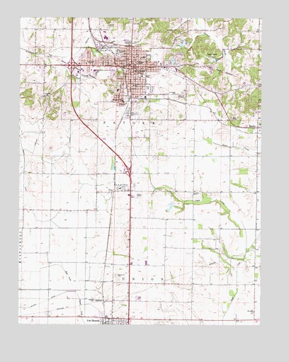
Princeton, IN USGS Topographic Map
Click on map above to begin viewing in our Map Viewer.

This topographic map contains these locations and features:
Feature Name Type Latitude Longitude GNIS ID View Map
Archer CemeteryCemeteryN38.3717°W87.5795°430236View Map
Baldwin HeightsPopulated PlaceN38.3414°W87.5714°452107View Map
Baldwin Heights Elementary SchoolSchoolN38.3414°W87.5714°430453View Map
Brown DitchCanalN38.3245°W87.6242°431617View Map
Camp CarsonParkN38.3592°W87.5259°432015View Map
City of PrincetonCivilN38.3552°W87.5785°2396277View Map
Columbia ChurchChurchN38.3428°W87.6106°432815View Map
DouglasPopulated PlaceN38.3306°W87.5017°433652View Map
DurhamPopulated PlaceN38.2598°W87.5811°433808View Map
Durham CemeteryCemeteryN38.2600°W87.5859°433809View Map
Enon ChurchChurchN38.3045°W87.5678°434212View Map
Fort BranchPopulated PlaceN38.2512°W87.5811°434683View Map
Fort Branch Fire Department Station 2BuildingN38.2599°W87.5773°2626185View Map
Fort Gibson (historical)Populated PlaceN38.2773°W87.5078°452145View Map
Franklin SchoolSchoolN38.3475°W87.5661°434778View Map
Gibson CountyCivilN38.3118°W87.5846°450354View Map
Gibson County Emergency Medical Services Station 3BuildingN38.3615°W87.5895°2719408View Map
Gibson County Rescue ServiceBuildingN38.3584°W87.5752°2701361View Map
Gibson County Sheriff's OfficeBuildingN38.3574°W87.5671°2758330View Map
Gibson General HospitalHospitalN38.3609°W87.5901°2660444View Map
Hight ChapelChurchN38.3334°W87.5150°436175View Map
KingPopulated PlaceN38.3042°W87.5761°437317View Map
Lafayette ParkParkN38.3612°W87.5739°437503View Map
Lake GibsonReservoirN38.3644°W87.5408°448652View Map
Lake Gibson Conservation DamDamN38.3634°W87.5400°448651View Map
Lowell Elementary SchoolSchoolN38.3545°W87.5706°438360View Map
Maple Hill CemeteryCemeteryN38.3436°W87.5408°438565View Map
Odd Fellows CemeteryCemeteryN38.3648°W87.5695°440503View Map
PrincetonPopulated PlaceN38.3553°W87.5675°452074View Map
Princeton Community High SchoolSchoolN38.3567°W87.5628°446989View Map
Princeton Fire Department Territory Station 1 HeadquartersBuildingN38.3584°W87.5753°2625688View Map
Princeton Fire Territory Station 2BuildingN38.3514°W87.6129°2626574View Map
Princeton Fire Territory Station 3BuildingN38.3174°W87.5677°2626206View Map
Princeton Fire Territory Station 4BuildingN38.3547°W87.5430°2625781View Map
Princeton Police DepartmentBuildingN38.3564°W87.5706°2758024View Map
Richland CreekStreamN38.3589°W87.6036°441969View Map
Riley SchoolSchoolN38.3589°W87.5622°442026View Map
Saint Joseph SchoolSchoolN38.3514°W87.5617°442647View Map
Saint Josephs CemeteryCemeteryN38.3431°W87.5447°442629View Map
Saint Lucas ChurchChurchN38.2553°W87.5034°442662View Map
Sand CreekStreamN38.3467°W87.5347°442962View Map
South Side ParkParkN38.3464°W87.5586°443855View Map
Toops DitchCanalN38.2687°W87.5989°444815View Map
Township of PatokaCivilN38.3493°W87.5925°453709View Map
Walnut Hill CemeteryCemeteryN38.2700°W87.5745°445432View Map
Warnock CemeteryCemeteryN38.3642°W87.5667°445478View Map
WRAY-FM (Princeton)TowerN38.3570°W87.5903°448923View Map

Note: Coordinates in the location and feature list above are referenced to NAD83 datum.


Copyright (C) 2008-2024 Ryan Niemi / Sunset Dynamics ... All Rights Reserved