TopoQuest Logo
Do you find TopoQuest useful?
Help keep TopoQuest running and adding new maps/features by donating!
Bitcoin:  19c7KJd3qBynnjoSw5npx9KScwjBe4ifkT
Litecoin:  LXs6TkuXGGXo1vDsWCkWVdjQX94eUKd6ui
Home View Maps Find Maps Find Places Resources & Links


Prentiss West, Mississippi Topographic Map

USGS Map Title: Prentiss West, MS
USGS Map MRC: 31089E8
DRG (GeoTIFF) Download: o31089e8.tif


Neighboring USGS Topographic Map Quads:


  Monticello NE, MS  
31090F1
 

  New Hebron, MS  
31089F8
 

  Mount Carmel, MS  
31089F7
 

  Monticello, MS  
31090E1
 

  Prentiss West, MS  
31089E8
 

  Prentiss East, MS  
31089E7
 

  Tilton, MS  
31090D1
 

  Oak Vale, MS  
31089D8
 

  Bunker Hill, MS  
31089D7


Map MRC Location:

N32°
W90°
N32°
W89°
H8 H7 H6 H5 H4 H3 H2 H1
G8 G7 G6 G5 G4 G3 G2 G1
F8 F7 F6 F5 F4 F3 F2 F1
E8 E7 E6 E5 E4 E3 E2 E1
D8 D7 D6 D5 D4 D3 D2 D1
C8 C7 C6 C5 C4 C3 C2 C1
B8 B7 B6 B5 B4 B3 B2 B1
A8 A7 A6 A5 A4 A3 A2 A1
N31°
W90°
N31°
W89°

Prentiss West, MS USGS 1:24K Topographic Map Preview:
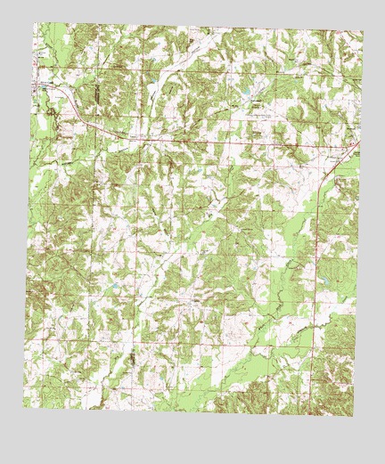
Prentiss West, MS USGS Topographic Map
Click on map above to begin viewing in our Map Viewer.

This topographic map contains these locations and features:
Feature Name Type Latitude Longitude GNIS ID View Map
Armstrong CemeteryCemeteryN31.5804°W89.9734°691264View Map
Bethany Baptist ChurchChurchN31.5827°W89.8831°666864View Map
Bethany CemeteryCemeteryN31.5832°W89.8826°691251View Map
Beulah Williams Elementary SchoolSchoolN31.6149°W89.9973°711682View Map
Brady CemeteryCemeteryN31.5807°W89.8981°667510View Map
Bullock CemeteryCemeteryN31.5788°W89.8812°691250View Map
Burkett CemeteryCemeteryN31.5149°W89.8995°691246View Map
Burkett CemeteryCemeteryN31.5391°W89.8937°691247View Map
Burkett CemeteryCemeteryN31.5438°W89.9145°691248View Map
Butler CemeteryCemeteryN31.5691°W89.9287°691257View Map
Cole CemeteryCemeteryN31.5835°W89.9292°691256View Map
Dry Creek School (historical)SchoolN31.5432°W89.9334°689728View Map
Green Grove CemeteryCemeteryN31.6179°W89.8762°691253View Map
Green Grove ChurchChurchN31.6179°W89.8770°670665View Map
Highway 84 West Fire Department Station 1 HeadquartersBuildingN31.5504°W89.9319°2668060View Map
Highway 84 West Fire Department Station 2BuildingN31.6239°W89.9331°2668061View Map
Hooker HollowValleyN31.5796°W89.9907°671389View Map
Hooker Hollow CreekStreamN31.5791°W89.9979°711128View Map
Jaybird CreekStreamN31.5199°W89.9140°671814View Map
Legions Lake DamDamN31.6052°W89.9201°680784View Map
LucasPopulated PlaceN31.5879°W89.9584°672939View Map
Lucas CemeteryCemeteryN31.6116°W89.9654°672940View Map
Lucas ChurchChurchN31.5877°W89.9601°672941View Map
Lucas School (historical)SchoolN31.5807°W89.9401°689751View Map
Mikell CemeteryCemeteryN31.6202°W89.9412°673561View Map
Mount Olive CemeteryCemeteryN31.6152°W89.8987°674105View Map
Nelda Rankin Lake DamDamN31.5452°W89.8867°680753View Map
Nichols CemeteryCemeteryN31.5029°W89.9101°691245View Map
Oak Grove CemeteryCemeteryN31.6238°W89.9329°691255View Map
Oak Grove ChurchChurchN31.6229°W89.9320°675027View Map
Oak Ridge School (historical)SchoolN31.5702°W89.8765°689755View Map
Oatis CemeteryCemeteryN31.5516°W89.9504°691259View Map
Patterson-Garner-Loftin CemeteryCemeteryN31.5991°W89.9181°691254View Map
Pleasant Hill ChurchChurchN31.5599°W89.9192°676059View Map
Polk CemeteryCemeteryN31.5863°W89.8887°691252View Map
Prentiss Christian SchoolSchoolN31.5982°W89.8784°689762View Map
Prentiss Lagoon DamDamN31.5718°W89.8867°680768View Map
Prentiss-Jefferson Davis County AirportAirportN31.5961°W89.9060°680319View Map
ProgressPopulated PlaceN31.5352°W89.9379°676345View Map
Progress CemeteryCemeteryN31.5327°W89.9345°691260View Map
Progress School (historical)SchoolN31.5346°W89.9373°689767View Map
Rose Hill ChurchChurchN31.5260°W89.9890°676853View Map
Shady Grove CemeteryCemeteryN31.5729°W89.9723°691265View Map
Shady Grove ChurchChurchN31.5732°W89.9723°677558View Map
Silver CreekPopulated PlaceN31.6052°W89.9984°677792View Map
Silver Creek Attendance Center (historical)SchoolN31.6027°W89.9987°709272View Map
Silver Creek Fire and RescueBuildingN31.6064°W89.9987°2668080View Map
Silver Creek Post OfficePost OfficeN31.6058°W89.9988°2768578View Map
South Pleasant Hill CemeteryCemeteryN31.5591°W89.9201°691258View Map
Speights CemeteryCemeteryN31.5049°W89.9237°691261View Map
Stamps CemeteryCemeteryN31.5602°W89.8917°691249View Map
Supervisor District 1CivilN31.5581°W89.8798°711914View Map
Taylor CemeteryCemeteryN31.5132°W89.9345°691262View Map
Taylor CemeteryCemeteryN31.5071°W89.9509°691263View Map
Tyrone CemeteryCemeteryN31.5838°W89.8834°679020View Map
Watts HollowValleyN31.5533°W89.9447°679388View Map
Weathersbys Box (historical)LocaleN31.5982°W89.9456°689778View Map
White Sand School (historical)SchoolN31.5202°W89.8856°689779View Map
WhitesandPopulated PlaceN31.6013°W89.9184°692319View Map

Note: Coordinates in the location and feature list above are referenced to NAD83 datum.


Copyright (C) 2008-2024 Ryan Niemi / Sunset Dynamics ... All Rights Reserved