TopoQuest Logo
Do you find TopoQuest useful?
Help keep TopoQuest running and adding new maps/features by donating!
Bitcoin:  19c7KJd3qBynnjoSw5npx9KScwjBe4ifkT
Litecoin:  LXs6TkuXGGXo1vDsWCkWVdjQX94eUKd6ui
Home View Maps Find Maps Find Places Resources & Links


Big Bay, Michigan Topographic Map

USGS Map Title: Big Bay, MI
USGS Map MRC: 46087G6
DRG (GeoTIFF) Download: o46087g6.tif


Neighboring USGS Topographic Map Quads:


  Huron Mountain, MI  
46087H7


  Ives Hill, MI  
46087G7
 

  Big Bay, MI  
46087G6
 

  Granite Point, MI  
46087G5
 

  Silver Lake Basin, MI  
46087F7
 

  Negaunee NW, MI  
46087F6
 

  Buckroe, MI  
46087F5


Map MRC Location:

N47°
W88°
N47°
W87°
H8 H7 H6 H5 H4 H3 H2 H1
G8 G7 G6 G5 G4 G3 G2 G1
F8 F7 F6 F5 F4 F3 F2 F1
E8 E7 E6 E5 E4 E3 E2 E1
D8 D7 D6 D5 D4 D3 D2 D1
C8 C7 C6 C5 C4 C3 C2 C1
B8 B7 B6 B5 B4 B3 B2 B1
A8 A7 A6 A5 A4 A3 A2 A1
N46°
W88°
N46°
W87°

Big Bay, MI USGS 1:24K Topographic Map Preview:
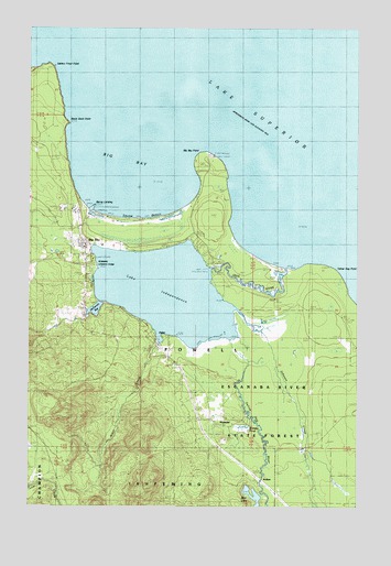
Big Bay, MI USGS Topographic Map
Click on map above to begin viewing in our Map Viewer.

This topographic map contains these locations and features:
Feature Name Type Latitude Longitude GNIS ID View Map
AlderPopulated PlaceN46.7894°W87.6974°619917View Map
Alder CreekStreamN46.7916°W87.7010°619922View Map
Alder FallsFallsN46.7794°W87.7106°2336607View Map
AntlersPopulated PlaceN46.7544°W87.6560°1617418View Map
Bay Cliff Health CampLocaleN46.8277°W87.7321°620779View Map
Bear LakeLakeN46.7526°W87.6650°620871View Map
Big BayPopulated PlaceN46.8158°W87.7285°621285View Map
Big BayBayN46.8391°W87.7096°621286View Map
Big Bay CemeteryCemeteryN46.8206°W87.7358°2336786View Map
Big Bay Census Designated PlaceCensusN46.8147°W87.6995°2393337View Map
Big Bay PointCapeN46.8402°W87.6832°621288View Map
Big Bay Post OfficePost OfficeN46.8191°W87.7313°2336751View Map
Big Bay Station (historical)LocaleN46.8172°W87.7269°2336752View Map
Black Rock CapeCapeN46.8499°W87.7351°1618257View Map
Brandts PondLakeN46.7708°W87.6679°1618253View Map
Burns LandingPopulated PlaceN46.8274°W87.7290°1617467View Map
HomeierPopulated PlaceN46.7724°W87.6799°1617625View Map
Iron RiverStreamN46.8124°W87.6529°1617989View Map
Johnson CreekStreamN46.7955°W87.6618°1618032View Map
Lake IndependenceReservoirN46.8059°W87.6979°628952View Map
McKenzie BayLakeN46.8014°W87.7250°631941View Map
Perkins County ParkParkN46.8110°W87.7268°1618254View Map
Powell Township Fire Department and Emergency Medical Services Station 1 Big BayBuildingN46.8147°W87.7278°2626792View Map
Powell Township SchoolSchoolN46.8178°W87.7289°2336755View Map
Presbyterian Church of Big BayChurchN46.8178°W87.7286°2336753View Map
Saint Mary's Catholic ChurchChurchN46.8175°W87.7281°2336754View Map
Salmon Trout PointCapeN46.8627°W87.7446°637128View Map
Squaw BeachBeachN46.8249°W87.7107°638663View Map
Yellow Dog PointCapeN46.8105°W87.6354°1616879View Map
Yellow Dog RiverStreamN46.7902°W87.6649°1616880View Map

Note: Coordinates in the location and feature list above are referenced to NAD83 datum.


Copyright (C) 2008-2024 Ryan Niemi / Sunset Dynamics ... All Rights Reserved