TopoQuest Logo
Do you find TopoQuest useful?
Help keep TopoQuest running and adding new maps/features by donating!
Bitcoin:  19c7KJd3qBynnjoSw5npx9KScwjBe4ifkT
Litecoin:  LXs6TkuXGGXo1vDsWCkWVdjQX94eUKd6ui
Home View Maps Find Maps Find Places Resources & Links


Poughkeepsie, Arkansas Topographic Map

USGS Map Title: Poughkeepsie, AR
USGS Map MRC: 36091A4
DRG (GeoTIFF) Download: o36091a4.tif


Neighboring USGS Topographic Map Quads:


  Ash Flat, AR  
36091B5
 

  Sitka, AR  
36091B4
 

  Ravenden, AR  
36091B3
 

  Evening Shade, AR  
36091A5
 

  Poughkeepsie, AR  
36091A4
 

  Smithville, AR  
36091A3
 

  Cave City, AR  
35091H5
 

  Grange, AR  
35091H4
 

  Strawberry, AR  
35091H3


Map MRC Location:

N37°
W92°
N37°
W91°
H8 H7 H6 H5 H4 H3 H2 H1
G8 G7 G6 G5 G4 G3 G2 G1
F8 F7 F6 F5 F4 F3 F2 F1
E8 E7 E6 E5 E4 E3 E2 E1
D8 D7 D6 D5 D4 D3 D2 D1
C8 C7 C6 C5 C4 C3 C2 C1
B8 B7 B6 B5 B4 B3 B2 B1
A8 A7 A6 A5 A4 A3 A2 A1
N36°
W92°
N36°
W91°

Poughkeepsie, AR USGS 1:24K Topographic Map Preview:
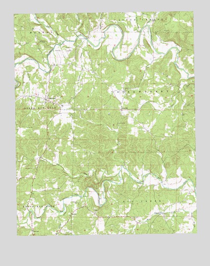
Poughkeepsie, AR USGS Topographic Map
Click on map above to begin viewing in our Map Viewer.

This topographic map contains these locations and features:
Feature Name Type Latitude Longitude GNIS ID View Map
Bandy BranchStreamN36.0120°W91.3790°46070View Map
Ben-GayLocaleN36.0120°W91.4624°76302View Map
Blakes BranchStreamN36.1151°W91.4121°45736View Map
Bridgeport (historical)Populated PlaceN36.1112°W91.4493°77331View Map
Brooks Hurricane HollowValleyN36.1140°W91.4582°46982View Map
CalaminePopulated PlaceN36.0115°W91.3990°47275View Map
Calamine Post Office (historical)Post OfficeN36.0115°W91.4001°84359View Map
Cedar CreekStreamN36.0367°W91.4237°47582View Map
Chandler CreekStreamN36.0970°W91.4987°47685View Map
Fool CreekStreamN36.0345°W91.4287°49149View Map
Freeman BranchStreamN36.1092°W91.4490°49236View Map
Grange - Calamine Volunteer Fire Department SubstationBuildingN36.0190°W91.3879°2116494View Map
Hurricane CreekStreamN36.1117°W91.4562°50450View Map
James Spring CemeteryCemeteryN36.0626°W91.4299°50583View Map
Jarrett CemeteryCemeteryN36.0612°W91.4924°50593View Map
Lebanon ChurchChurchN36.0815°W91.4237°51035View Map
Lick BranchStreamN36.1053°W91.4729°51134View Map
Marvin CemeteryCemeteryN36.0670°W91.3840°51718View Map
McAdams CemeteryCemeteryN36.0184°W91.4582°51772View Map
Meeks BranchStreamN36.1142°W91.4379°51896View Map
Mill CreekStreamN36.1178°W91.4076°52028View Map
Mount Pisgah CemeteryCemeteryN36.0381°W91.4882°52378View Map
NelsonvillePopulated PlaceN36.0701°W91.4265°52613View Map
North Big CreekStreamN36.1098°W91.4668°52806View Map
Parsley CemeteryCemeteryN36.0009°W91.4676°53203View Map
PoughkeepsiePopulated PlaceN36.0767°W91.4793°78088View Map
Poughkeepsie Elementary SchoolSchoolN36.0728°W91.4679°66168View Map
Poughkeepsie High SchoolSchoolN36.0728°W91.4674°66169View Map
Poughkeepsie Post OfficePost OfficeN36.0762°W91.4787°84686View Map
Poughkeepsie Volunteer Fire DepartmentBuildingN36.0778°W91.4785°2116999View Map
Reed (historical)Populated PlaceN36.0737°W91.4265°66170View Map
Rings ChapelChurchN36.0026°W91.4893°54045View Map
Runnels BranchStreamN36.0948°W91.4832°54266View Map
Spotts CemeteryCemeteryN36.1042°W91.4646°55072View Map
Spring CreekStreamN36.0184°W91.4676°55096View Map
Street LakeReservoirN36.0384°W91.4118°80996View Map
Street Lake DamDamN36.0384°W91.4118°80995View Map
Township of Big CreekCivilN36.0171°W91.4073°69134View Map
Township of Big Rock (historical)CivilN36.0501°W91.4876°70211View Map
Township of North Big RockCivilN36.0701°W91.4867°69146View Map
Township of South Big RockCivilN36.0107°W91.4893°69153View Map
Township of StrawberryCivilN36.0788°W91.4121°69156View Map

Note: Coordinates in the location and feature list above are referenced to NAD83 datum.


Copyright (C) 2008-2024 Ryan Niemi / Sunset Dynamics ... All Rights Reserved