TopoQuest Logo
Do you find TopoQuest useful?
Help keep TopoQuest running and adding new maps/features by donating!
Bitcoin:  19c7KJd3qBynnjoSw5npx9KScwjBe4ifkT
Litecoin:  LXs6TkuXGGXo1vDsWCkWVdjQX94eUKd6ui
Home View Maps Find Maps Find Places Resources & Links


Potters Hill, North Carolina Topographic Map

USGS Map Title: Potters Hill, NC
USGS Map MRC: 34077H6
DRG (GeoTIFF) Download: o34077h6.tif


Neighboring USGS Topographic Map Quads:


  Albertson, NC  
35077A7
 

  Pink Hill, NC  
35077A6
 

  Comfort, NC  
35077A5
 

  Beulaville, NC  
34077H7
 

  Potters Hill, NC  
34077H6
 

  Richlands, NC  
34077H5
 

  Chinquapin, NC  
34077G7
 

  Lyman, NC  
34077G6
 

  Catherine Lake, NC  
34077G5


Map MRC Location:

N35°
W78°
N35°
W77°
H8 H7 H6 H5 H4 H3 H2 H1
G8 G7 G6 G5 G4 G3 G2 G1
F8 F7 F6 F5 F4 F3 F2 F1
E8 E7 E6 E5 E4 E3 E2 E1
D8 D7 D6 D5 D4 D3 D2 D1
C8 C7 C6 C5 C4 C3 C2 C1
B8 B7 B6 B5 B4 B3 B2 B1
A8 A7 A6 A5 A4 A3 A2 A1
N34°
W78°
N34°
W77°

Potters Hill, NC USGS 1:24K Topographic Map Preview:
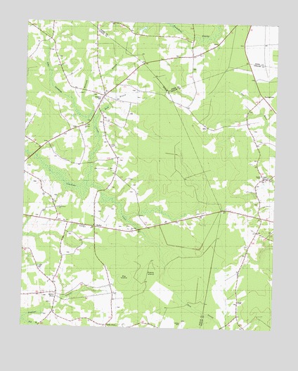
Potters Hill, NC USGS Topographic Map
Click on map above to begin viewing in our Map Viewer.

This topographic map contains these locations and features:
Feature Name Type Latitude Longitude GNIS ID View Map
Baysden ChapelChurchN34.9382°W77.6314°1003966View Map
Beaverdam CreekStreamN34.9985°W77.6772°1003797View Map
Bethany ChapelChurchN34.8891°W77.7414°981065View Map
Big BranchStreamN34.8777°W77.7491°1026311View Map
Big IslandFlatN34.8960°W77.6955°1026008View Map
Buck BranchStreamN34.9638°W77.7125°1003959View Map
Cedar ForkPopulated PlaceN34.8768°W77.7078°1025230View Map
Eagles Nest AirportAirportN34.9801°W77.6977°997869View Map
HadleyPopulated PlaceN34.9166°W77.7141°1003962View Map
Haw BranchPopulated PlaceN34.9366°W77.6316°1025376View Map
JarmantownPopulated PlaceN34.9702°W77.6322°1020934View Map
Little Limestone CreekStreamN34.9335°W77.7205°988699View Map
Maranatha ChurchChurchN34.9160°W77.7186°1003963View Map
Morgans ChapelChurchN34.8863°W77.6422°1003965View Map
New Hope ChurchChurchN34.9152°W77.6961°1003964View Map
Piney Grove ChurchChurchN34.9241°W77.7319°1003961View Map
Potters HillPopulated PlaceN34.9688°W77.7103°1025627View Map
Potters Hill Census Designated PlaceCensusN34.9645°W77.6983°2628649View Map
Potters Hill SchoolSchoolN34.9707°W77.7116°992753View Map
Potters Hill Volunteer Fire DepartmentBuildingN34.9703°W77.7107°2639428View Map
Quinns StorePopulated PlaceN34.8891°W77.7325°1003960View Map
Reedy IslandFlatN34.8988°W77.6830°1026007View Map
Sand Hill ChurchChurchN34.9557°W77.7194°994246View Map
Tharon (historical)LocaleN34.9746°W77.7030°1008039View Map
Tuckahoe Post Office (historical)Post OfficeN34.9879°W77.6675°1008017View Map
Whiteoak BranchStreamN34.9618°W77.7172°1004499View Map

Note: Coordinates in the location and feature list above are referenced to NAD83 datum.


Copyright (C) 2008-2024 Ryan Niemi / Sunset Dynamics ... All Rights Reserved