TopoQuest Logo
Do you find TopoQuest useful?
Help keep TopoQuest running and adding new maps/features by donating!
Bitcoin:  19c7KJd3qBynnjoSw5npx9KScwjBe4ifkT
Litecoin:  LXs6TkuXGGXo1vDsWCkWVdjQX94eUKd6ui
Home View Maps Find Maps Find Places Resources & Links


Poteet, Texas Topographic Map

USGS Map Title: Poteet, TX
USGS Map MRC: 29098A5
DRG (GeoTIFF) Download: o29098a5.tif


Neighboring USGS Topographic Map Quads:


  Somerset, TX  
29098B6
 

  Thelma, TX  
29098B5
 

  Losoya, TX  
29098B4
 

  Rossville, TX  
29098A6
 

  Poteet, TX  
29098A5
 

  Leming, TX  
29098A4
 

  Dobrowolski, TX  
28098H6
 

  Jourdanton, TX  
28098H5
 

  Pleasanton, TX  
28098H4


Map MRC Location:

N30°
W99°
N30°
W98°
H8 H7 H6 H5 H4 H3 H2 H1
G8 G7 G6 G5 G4 G3 G2 G1
F8 F7 F6 F5 F4 F3 F2 F1
E8 E7 E6 E5 E4 E3 E2 E1
D8 D7 D6 D5 D4 D3 D2 D1
C8 C7 C6 C5 C4 C3 C2 C1
B8 B7 B6 B5 B4 B3 B2 B1
A8 A7 A6 A5 A4 A3 A2 A1
N29°
W99°
N29°
W98°

Poteet, TX USGS 1:24K Topographic Map Preview:
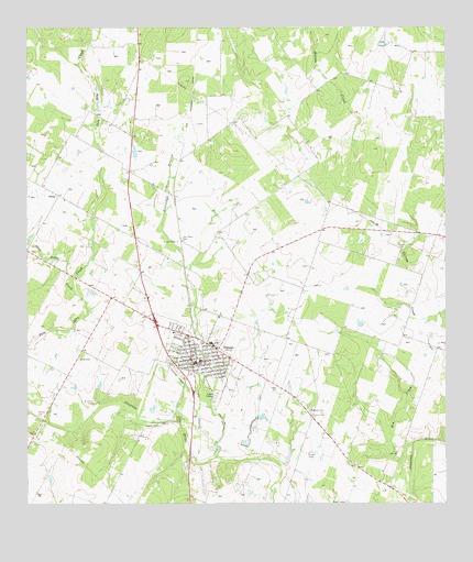
Poteet, TX USGS Topographic Map
Click on map above to begin viewing in our Map Viewer.

This topographic map contains these locations and features:
Feature Name Type Latitude Longitude GNIS ID View Map
Agua Negra CreekStreamN29.0566°W98.6109°1350907View Map
Alderman Farm AirportAirportN29.0028°W98.5707°1387358View Map
Atascosa County Emergency Medical ServicesBuildingN29.0370°W98.5726°2655931View Map
City of PoteetCivilN29.0373°W98.5728°2411477View Map
DittoLocaleN29.0814°W98.6161°1356049View Map
Elm CreekStreamN29.0161°W98.5103°1356943View Map
Estrada CemeteryCemeteryN29.0247°W98.5406°1357087View Map
Garcia CemeteryCemeteryN29.0236°W98.5400°1357859View Map
Herrera CemeteryCemeteryN29.0236°W98.6217°1359080View Map
KBOP-AM (Pleasanton)TowerN29.0002°W98.5309°1385664View Map
KBOP-FM (Pleasanton)TowerN29.0005°W98.5306°1385973View Map
Madre Dolorosa CemeteryCemeteryN29.0227°W98.5814°1362065View Map
PoteetPopulated PlaceN29.0405°W98.5681°1365680View Map
Poteet CemeteryCemeteryN29.0691°W98.5803°1365681View Map
Poteet City HallBuildingN29.0374°W98.5751°2753163View Map
Poteet Police DepartmentBuildingN29.0381°W98.5746°2750437View Map
Poteet Post OfficePost OfficeN29.0366°W98.5755°2731094View Map
Poteet Volunteer Fire DepartmentBuildingN29.0373°W98.5728°2552071View Map
Rutledge HollowValleyN29.0127°W98.5693°1367057View Map
San Pedro CemeteryCemeteryN29.0700°W98.5792°1367534View Map
Shiloh CemeteryCemeteryN29.0677°W98.5134°1368148View Map
Willborn CemeteryCemeteryN29.0272°W98.6053°1371555View Map
Zavala CemeteryCemeteryN29.0208°W98.5859°1372083View Map

Note: Coordinates in the location and feature list above are referenced to NAD83 datum.


Copyright (C) 2008-2024 Ryan Niemi / Sunset Dynamics ... All Rights Reserved