TopoQuest Logo
Do you find TopoQuest useful?
Help keep TopoQuest running and adding new maps/features by donating!
Bitcoin:  19c7KJd3qBynnjoSw5npx9KScwjBe4ifkT
Litecoin:  LXs6TkuXGGXo1vDsWCkWVdjQX94eUKd6ui
Home View Maps Find Maps Find Places Resources & Links


Porum, Oklahoma Topographic Map

USGS Map Title: Porum, OK
USGS Map MRC: 35095C3
DRG (GeoTIFF) Download: o35095c3.tif


Neighboring USGS Topographic Map Quads:


  Warner NW, OK  
35095D4
 

  Warner, OK  
35095D3
 

  Holt Mountain, OK  
35095D2
 

  Texanna, OK  
35095C4
 

  Porum, OK  
35095C3
 

  Stigler West, OK  
35095C2
 

  Enterprise, OK  
35095B4
 

  Quinton North, OK  
35095B3
 

  Sans Bois, OK  
35095B2


Map MRC Location:

N36°
W96°
N36°
W95°
H8 H7 H6 H5 H4 H3 H2 H1
G8 G7 G6 G5 G4 G3 G2 G1
F8 F7 F6 F5 F4 F3 F2 F1
E8 E7 E6 E5 E4 E3 E2 E1
D8 D7 D6 D5 D4 D3 D2 D1
C8 C7 C6 C5 C4 C3 C2 C1
B8 B7 B6 B5 B4 B3 B2 B1
A8 A7 A6 A5 A4 A3 A2 A1
N35°
W96°
N35°
W95°

Porum, OK USGS 1:24K Topographic Map Preview:
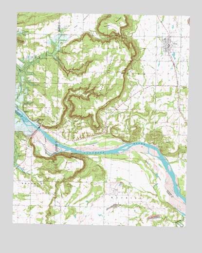
Porum, OK USGS Topographic Map
Click on map above to begin viewing in our Map Viewer.

This topographic map contains these locations and features:
Feature Name Type Latitude Longitude GNIS ID View Map
Asbury Cemetery (historical)CemeteryN35.3112°W95.3586°1802808View Map
Belle Starr CreekStreamN35.2932°W95.3233°1089987View Map
Black Haw MountainSummitN35.3582°W95.3750°1090206View Map
Brooken CreekStreamN35.3143°W95.3733°1090519View Map
Buckner Cemetery (historical)CemeteryN35.2959°W95.3489°1802809View Map
Coleman CemeteryCemeteryN35.3323°W95.2550°1091573View Map
Eufaula DamDamN35.3067°W95.3581°1092653View Map
Hensley MountainSummitN35.3695°W95.2964°1093678View Map
Hi Early CemeteryCemeteryN35.3134°W95.3533°1093690View Map
Hi Early MountainSummitN35.3537°W95.2905°1093691View Map
HoytPopulated PlaceN35.2718°W95.3022°1093989View Map
Hoyt CemeteryCemeteryN35.2746°W95.2967°2709102View Map
Hoyt Census Designated PlaceCensusN35.2680°W95.3050°2629922View Map
Hoyt Volunteer Fire DepartmentBuildingN35.2713°W95.3018°2657266View Map
Oknoname 101017 DamDamN35.3134°W95.3419°1755376View Map
Oknoname 101017 ReservoirReservoirN35.3134°W95.3419°1755377View Map
PorumPopulated PlaceN35.3562°W95.2655°1096845View Map
Porum Elementary SchoolSchoolN35.3613°W95.2684°1790781View Map
Porum GapGapN35.3623°W95.3050°1096846View Map
Porum High SchoolSchoolN35.3613°W95.2684°1790436View Map
Porum LakeReservoirN35.3514°W95.2613°1755329View Map
Porum Lake DamDamN35.3534°W95.2602°1755328View Map
Porum Landing Fire Protection AssociationBuildingN35.3618°W95.3628°2657018View Map
Porum Police DepartmentBuildingN35.3568°W95.2626°2757520View Map
Porum Post OfficePost OfficeN35.3589°W95.2656°1818327View Map
Porum Volunteer Fire DepartmentBuildingN35.3591°W95.2650°2657044View Map
Sandy RidgeRidgeN35.2879°W95.3377°1097827View Map
Sandy Ridge SchoolSchoolN35.2723°W95.3608°1097829View Map
Starr CemeteryCemeteryN35.2940°W95.2508°1098501View Map
Tater HillSummitN35.3612°W95.2994°1098762View Map
Taylor BluffCliffN35.2901°W95.3319°1098766View Map
Town of PorumCivilN35.3569°W95.2634°2412500View Map
Township of PorumCivilN35.3404°W95.2919°1824632View Map

Note: Coordinates in the location and feature list above are referenced to NAD83 datum.


Copyright (C) 2008-2024 Ryan Niemi / Sunset Dynamics ... All Rights Reserved