TopoQuest Logo
Do you find TopoQuest useful?
Help keep TopoQuest running and adding new maps/features by donating!
Bitcoin:  19c7KJd3qBynnjoSw5npx9KScwjBe4ifkT
Litecoin:  LXs6TkuXGGXo1vDsWCkWVdjQX94eUKd6ui
Home View Maps Find Maps Find Places Resources & Links


Port Sanilac, Michigan Topographic Map

USGS Map Title: Port Sanilac, MI
USGS Map MRC: 43082D5
DRG (GeoTIFF) Download: o43082d5.tif


Neighboring USGS Topographic Map Quads:


  Deckerville, MI  
43082E6
 

  Richmondville, MI  
43082E5


  Carsonville, MI  
43082D6
 

  Port Sanilac, MI  
43082D5


  Applegate, MI  
43082C6
 

  Croswell, MI  
43082C5


Map MRC Location:

N44°
W83°
N44°
W82°
H8 H7 H6 H5 H4 H3 H2 H1
G8 G7 G6 G5 G4 G3 G2 G1
F8 F7 F6 F5 F4 F3 F2 F1
E8 E7 E6 E5 E4 E3 E2 E1
D8 D7 D6 D5 D4 D3 D2 D1
C8 C7 C6 C5 C4 C3 C2 C1
B8 B7 B6 B5 B4 B3 B2 B1
A8 A7 A6 A5 A4 A3 A2 A1
N43°
W83°
N43°
W82°

Port Sanilac, MI USGS 1:24K Topographic Map Preview:
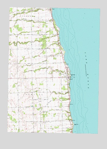
Port Sanilac, MI USGS Topographic Map
Click on map above to begin viewing in our Map Viewer.

This topographic map contains these locations and features:
Feature Name Type Latitude Longitude GNIS ID View Map
Camp OzanamLocaleN43.3878°W82.5374°622620View Map
Cottage SchoolSchoolN43.4592°W82.5691°623864View Map
Crawford CreekStreamN43.4525°W82.5474°624031View Map
ForesterPopulated PlaceN43.4992°W82.5694°626285View Map
Forester CreekStreamN43.4978°W82.5658°626286View Map
Forester Post Office (historical)Post OfficeN43.4992°W82.5694°2554233View Map
Great Storm of 1913 Historical MarkerParkN43.4033°W82.5400°2554497View Map
Herron CreekStreamN43.4147°W82.5385°628150View Map
Hubbell Cemetery (historical)CemeteryN43.4006°W82.6000°2554464View Map
Huron Shores Estates Mobile Home ParkPopulated PlaceN43.4592°W82.5514°2554412View Map
Huron Shores Golf ClubLocaleN43.4722°W82.5611°2554411View Map
Lake Huron CampgroundLocaleN43.4983°W82.5667°2554172View Map
Lakeshore Internal MedicineHospitalN43.4289°W82.5411°2554407View Map
Liens CreekStreamN43.4364°W82.5391°630373View Map
Loop-Harrison House Historical MarkerParkN43.4244°W82.5431°2554495View Map
Masonic and Town Hall Historical MarkerParkN43.4314°W82.5425°2554483View Map
McKenzie CreekStreamN43.3953°W82.5374°631943View Map
Miller CreekStreamN43.4728°W82.5558°632363View Map
New London PointCapeN43.3839°W82.5333°633330View Map
NWS Signal StationLocaleN43.4311°W82.5396°1618411View Map
Port SanilacPopulated PlaceN43.4309°W82.5424°635267View Map
Port Sanilac Baptist ChurchChurchN43.4300°W82.5772°2554409View Map
Port Sanilac CemeteryCemeteryN43.4347°W82.5528°2554461View Map
Port Sanilac Fire DepartmentBuildingN43.4323°W82.5421°2554406View Map
Port Sanilac Health CenterHospitalN43.4308°W82.5469°2554405View Map
Port Sanilac LightLocaleN43.4278°W82.5385°1618409View Map
Port Sanilac Police DepartmentBuildingN43.4323°W82.5421°2554403View Map
Port Sanilac Post OfficePost OfficeN43.4319°W82.5425°2554402View Map
Ridge CemeteryCemeteryN43.3750°W82.5877°635905View Map
Saint John CemeteryCemeteryN43.3772°W82.5491°636698View Map
Saint John Lutheran ChurchChurchN43.4378°W82.5436°2554410View Map
Saint Mary ChurchChurchN43.4300°W82.5497°2554408View Map
Saint Marys CemeteryCemeteryN43.4286°W82.6027°636891View Map
Sanilac District LibraryBuildingN43.4303°W82.5492°2554404View Map
Sanilac MarinaLocaleN43.4303°W82.5374°1618410View Map
Sanilac Township HallLocaleN43.4317°W82.5463°1618414View Map
Sherman CreekStreamN43.4878°W82.5624°637761View Map
Township of SanilacCivilN43.4065°W82.5852°1627043View Map
Twin Hill CreekStreamN43.4089°W82.5374°1615236View Map
Village of Port SanilacCivilN43.4286°W82.5448°2399005View Map

Note: Coordinates in the location and feature list above are referenced to NAD83 datum.


Copyright (C) 2008-2024 Ryan Niemi / Sunset Dynamics ... All Rights Reserved