TopoQuest Logo
Do you find TopoQuest useful?
Help keep TopoQuest running and adding new maps/features by donating!
Bitcoin:  19c7KJd3qBynnjoSw5npx9KScwjBe4ifkT
Litecoin:  LXs6TkuXGGXo1vDsWCkWVdjQX94eUKd6ui
Home View Maps Find Maps Find Places Resources & Links


Port Matilda, Pennsylvania Topographic Map

USGS Map Title: Port Matilda, PA
USGS Map MRC: 40078G1
DRG (GeoTIFF) Download: o40078g1.tif


Neighboring USGS Topographic Map Quads:


  Philipsburg, PA  
40078H2
 

  Black Moshannon, PA  
40078H1
 

  Bear Knob, PA  
40077H8
 

  Sandy Ridge, PA  
40078G2
 

  Port Matilda, PA  
40078G1
 

  Julian, PA  
40077G8
 

  Tyrone, PA  
40078F2
 

  Franklinville, PA  
40078F1
 

  Pine Grove Mills, PA  
40077F8


Map MRC Location:

N41°
W79°
N41°
W78°
H8 H7 H6 H5 H4 H3 H2 H1
G8 G7 G6 G5 G4 G3 G2 G1
F8 F7 F6 F5 F4 F3 F2 F1
E8 E7 E6 E5 E4 E3 E2 E1
D8 D7 D6 D5 D4 D3 D2 D1
C8 C7 C6 C5 C4 C3 C2 C1
B8 B7 B6 B5 B4 B3 B2 B1
A8 A7 A6 A5 A4 A3 A2 A1
N40°
W79°
N40°
W78°

Port Matilda, PA USGS 1:24K Topographic Map Preview:
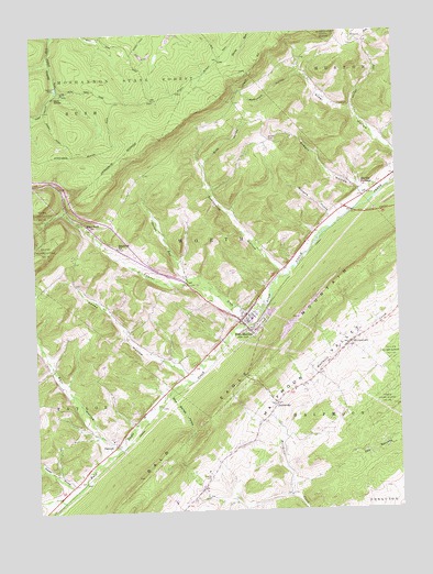
Port Matilda, PA USGS Topographic Map
Click on map above to begin viewing in our Map Viewer.

This topographic map contains these locations and features:
Feature Name Type Latitude Longitude GNIS ID View Map
Ardery HollowValleyN40.8339°W78.0111°1192081View Map
Bell HollowValleyN40.7668°W78.1002°1192116View Map
Big HollowValleyN40.7539°W78.1178°1192130View Map
Black Oak SchoolSchoolN40.8701°W78.0089°1201253View Map
Blackoak ChurchChurchN40.8192°W78.0961°1192157View Map
Blue Springs HollowValleyN40.7803°W78.0792°1192171View Map
Borough of Port MatildaCivilN40.8003°W78.0523°1215060View Map
Brown CemeteryCemeteryN40.8468°W78.0429°1192193View Map
Campfield TrailTrailN40.8678°W78.1033°1206391View Map
CentennialPopulated PlaceN40.7776°W78.0428°1192247View Map
Centennial School (historical)SchoolN40.7759°W78.0336°1201254View Map
Dayton DamDamN40.8617°W78.1167°1192333View Map
Flat RockPopulated PlaceN40.8251°W78.1064°1205045View Map
Fowler HollowValleyN40.7573°W78.1148°1192485View Map
Friends CemeteryCemeteryN40.7586°W78.0654°1192493View Map
Halfmoon ValleyValleyN40.7710°W78.0526°1176387View Map
HannahPopulated PlaceN40.7673°W78.0975°1205052View Map
Laurel RunStreamN40.8023°W78.0470°1192747View Map
Martha FurnacePopulated PlaceN40.8348°W78.0072°1205067View Map
McDonald HollowValleyN40.8643°W78.0331°1192909View Map
Oliver RunStreamN40.8062°W78.0600°1193065View Map
Port MatildaPopulated PlaceN40.7995°W78.0542°1193153View Map
Port Matilda Emergency Medical Services Company 27BuildingN40.7971°W78.0516°2719556View Map
Port Matilda Fire Company 15BuildingN40.8009°W78.0530°2644807View Map
Port Matilda Post OfficePost OfficeN40.8003°W78.0545°2779765View Map
Reese HollowValleyN40.7858°W78.0737°1193180View Map
Reese Hollow RunStreamN40.7842°W78.0720°1200592View Map
Sparrow RunStreamN40.7689°W78.0947°1212034View Map
StormstownPopulated PlaceN40.7934°W78.0167°1193484View Map
Stormstown Census Designated PlaceCensusN40.7890°W78.0191°2390361View Map
Sunnyside HollowValleyN40.8130°W78.0396°1193500View Map
Township of HalfmoonCivilN40.7730°W78.0241°1216126View Map
Township of WorthCivilN40.8215°W78.0647°1216142View Map
Turkey TrailTrailN40.8473°W78.1195°1206392View Map
Williams HollowValleyN40.8273°W78.0231°1193670View Map
Wills HollowValleyN40.8406°W78.0662°1193675View Map
Wolf RocksRangeN40.8578°W78.1167°1193686View Map
WTLR-FM (State College)TowerN40.8126°W78.0053°1200259View Map

Note: Coordinates in the location and feature list above are referenced to NAD83 datum.


Copyright (C) 2008-2024 Ryan Niemi / Sunset Dynamics ... All Rights Reserved