TopoQuest Logo
Do you find TopoQuest useful?
Help keep TopoQuest running and adding new maps/features by donating!
Bitcoin:  19c7KJd3qBynnjoSw5npx9KScwjBe4ifkT
Litecoin:  LXs6TkuXGGXo1vDsWCkWVdjQX94eUKd6ui
Home View Maps Find Maps Find Places Resources & Links


Ponsford, Minnesota Topographic Map

USGS Map Title: Ponsford, MN
USGS Map MRC: 46095H4
DRG (GeoTIFF) Download: o46095h4.tif


Neighboring USGS Topographic Map Quads:


  Many Point Lake, MN  
47095A5
 

  Big Rush Lake, MN  
47095A4
 

  Big Basswood Lake, MN  
47095A3
 

  Height of Land Lake, MN  
46095H5
 

  Ponsford, MN  
46095H4
 

  Osage, MN  
46095H3
 

  Toad Mountain, MN  
46095G5
 

  Evergreen, MN  
46095G4
 

  Wolf Lake, MN  
46095G3


Map MRC Location:

N47°
W96°
N47°
W95°
H8 H7 H6 H5 H4 H3 H2 H1
G8 G7 G6 G5 G4 G3 G2 G1
F8 F7 F6 F5 F4 F3 F2 F1
E8 E7 E6 E5 E4 E3 E2 E1
D8 D7 D6 D5 D4 D3 D2 D1
C8 C7 C6 C5 C4 C3 C2 C1
B8 B7 B6 B5 B4 B3 B2 B1
A8 A7 A6 A5 A4 A3 A2 A1
N46°
W96°
N46°
W95°

Ponsford, MN USGS 1:24K Topographic Map Preview:
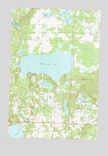
Ponsford, MN USGS Topographic Map
Click on map above to begin viewing in our Map Viewer.

This topographic map contains these locations and features:
Feature Name Type Latitude Longitude GNIS ID View Map
Aspinwall LakeLakeN46.9899°W95.4200°639484View Map
Bass LakeLakeN46.9048°W95.4196°639701View Map
Breck Memorial CemeteryCemeteryN46.9833°W95.3761°2108240View Map
Breck Memorial CemeteryCemeteryN46.9780°W95.3847°2108241View Map
Brenum LakeLakeN46.9567°W95.4855°640463View Map
Carsonville Volunteer Fire DepartmentBuildingN46.9696°W95.3813°2666489View Map
Chilton ParkParkN46.9077°W95.4184°641159View Map
Dumbbell LakeLakeN46.9275°W95.4478°642972View Map
Emmanuel ChurchChurchN46.9036°W95.4861°643363View Map
Emmanuel Lutheran CemeteryCemeteryN46.9039°W95.4867°2108238View Map
Fish CreekStreamN46.9583°W95.4253°643667View Map
Grand Medicine CemeteryCemeteryN46.9922°W95.4128°644328View Map
Green Water LakeLakeN46.9838°W95.4943°644430View Map
Jones LakeLakeN46.9454°W95.4900°645731View Map
Linbom LakeLakeN46.9138°W95.3977°646668View Map
Linbom Lake State Wildlife Management AreaParkN46.9113°W95.3909°646669View Map
Mission LakeLakeN46.9840°W95.3849°647990View Map
Mud LakeLakeN46.9950°W95.4480°648326View Map
Pine PointPopulated PlaceN46.9777°W95.3836°649489View Map
Pine Point Census Designated PlaceCensusN46.9889°W95.3883°2393185View Map
Pine Point ClinicHospitalN46.9778°W95.3833°2108629View Map
Pine Point SchoolSchoolN46.9789°W95.3803°2108630View Map
Plumb Post Office (historical)Post OfficeN46.9125°W95.4458°2108397View Map
PonsfordPopulated PlaceN46.9700°W95.3839°649629View Map
Ponsford Post Office (historical)Post OfficeN46.9700°W95.3836°2108628View Map
Saint Theodores CemeteryCemeteryN46.9886°W95.4122°651062View Map
Shell LakeLakeN46.9460°W95.4470°651943View Map
Shell Lake Resort and CampgroundLocaleN46.9389°W95.4844°2108299View Map
Smoky Hills State ForestForestN46.9405°W95.3939°652192View Map
SnellmanPopulated PlaceN46.8894°W95.4131°652203View Map
Snellman CemeteryCemeteryN46.8866°W95.4147°652204View Map
Snellman Post Office (historical)Post OfficeN46.8894°W95.4128°2108384View Map
Township of Shell LakeCivilN46.9336°W95.4775°665588View Map

Note: Coordinates in the location and feature list above are referenced to NAD83 datum.


Copyright (C) 2008-2024 Ryan Niemi / Sunset Dynamics ... All Rights Reserved